
DOWNLOAD MY NEW FREE JOESTRADAMUS WEATHER APP FOR ALL DEVICES
THE APP IS ABSOLUTELY FREE TO ALL BUT CONSIDERING SUBSCRIBING TO PATREON FOR A WEATHER EXPERIENCE FREE OF ADS, EXCLUSIVE VIDEOS FOR MEMBERS ONLY AND MUCH MORE…STARTS AT $2 A MONTH..MESSAGE ME AT ANY TIME
Sunshine Wednesday Northeast Storm About To Move Across The South
We had our little upper air disturbance move through last night with a little bit of rain in some places and not much if any in others and now we are sitting in sunshine from NYC Northern New Jersey, Long Island and Southern New England. The cloud line is sinking slowly southward and will probably wind up somewhere across Central and Southern New Jersey and Southeastern Pennsylvania. Keep a close eye on those clouds because they will be coming back northward tonight and Thursday as a warm front starts to move north. But we do have today with highs temperatures reaching the upper 50s to lower 60s where we have sunshine. We will be closer to the lower end of the numbers in areas that sit in cloud cover. For many this will be a very nice day indeed.
SATELLITE

REGIONAL RADAR

Not much is happening on the radar this morning. The overnight rain has disintegrated into a few showers scattered across Pennsylvania and that is just about it. Tonight the clouds come back northward and there could be a few passing showers after midnight with this warm front setting up to the south of NYC for Thursday.

Thursday the cloud issue will be in reverse with areas from Northeastern Pennsylvania, Northern New Jersey to the Hudson Valley Long Island & Connecticut sitting in clouds with the occasional passing spot shower and highs in the upper 50s to near 60. From Route 195 southward in New Jersey the sun breaks out and temperatures will reach into the 70s!
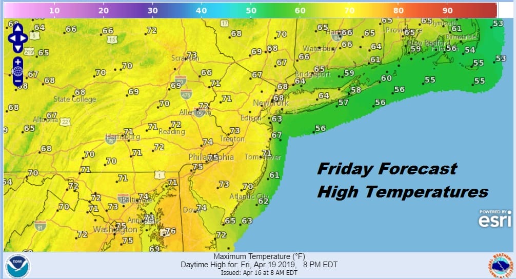
Friday we set up in the “warm” sector with an increasing south wind, lots of clouds, and the chance for showers by late afternoon and evening. Most highs will be in the 60s to near 70. Friday night into early Saturday afternoon we are going to see some downpours and perhaps a few thunderstorms. The heaviest rain will be well inland and west across Eastern Pennsylvania where rain amounts could reach several inches in some places. Further east rainfall amounts will be lower but it could still be on the order of an inch to an inch and a half. Not much has changed on overnight weather models regarding this idea.
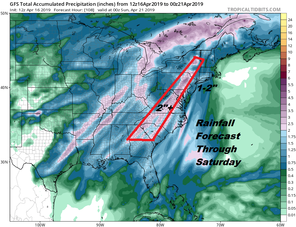
As far as severe weather potential is concerned it would seem that this time around unlike back on Sunday night Monday morning, severe weather will be further south and the emphasis here will be more on rain. It could turn rather windy along the coast of New Jersey and Long Island Friday night into Saturday morning with gusts over 40 mph possible.
Much of the rain will be over with by early afternoon Saturday as a cold front sweeps through. Highs will be in the 60s Saturday. Easter Sunday we are looking at clouds with some breaks of sunshine and the chance for some lingering showers. Much of the shower activity will be scattered in nature so not everyone sees rain. Highs will be in the 60s. Next week looks better with a slightly less active pattern so perhaps we could string together a couple of nice days back to back. We shall see.
MANY THANKS TO TROPICAL TIDBITS FOR THE USE OF MAPS
Please note that with regards to any tropical storms or hurricanes, should a storm be threatening, please consult your local National Weather Service office or your local government officials about what action you should be taking to protect life and property.


