DOWNLOAD MY NEW FREE JOESTRADAMUS WEATHER APP FOR ALL DEVICES
THE APP IS ABSOLUTELY FREE TO ALL BUT CONSIDERING SUBSCRIBING TO PATREON FOR A WEATHER EXPERIENCE FREE OF ADS, EXCLUSIVE VIDEOS FOR MEMBERS ONLY AND MUCH MORE…STARTS AT $2 A MONTH..MESSAGE ME AT ANY TIME
Sunshine Nice Wednesday Showers Arrive Friday Rain Friday Night Split Weekend
Last night’s cold front moved through without much fanfare other than a few showers and a little lightning & thunder. Dry is back and we are in for another nice day of sunshine. It will be a bit breezy today with a gusty northwest wind but entirely manageable. Highs will be in the upper 60s to lower 70s. The satellite loop shows low pressure spinning away in Southeastern Canada. To the southwest we have thunderstorms developing across the Western Gulf States where low pressure will be moving east. In the northern part of the jet stream we have energy and a cold front dropping into the Northern Plains. Both weather systems will take part in our weather at the end of the week.
SATELLITE

REGIONAL RADAR

Radars are quiet today with no issues. We will the sunshine today take temperatures in the upper 60s and lower 70s and tonight will be nice and clear with most lows in the 40s. Thursday some moisture from the Gulf States weather system will break away and move by to our south which could put us in some clouds. We will call it a mix of sun and clouds for Thursday with highs in the 60s to near 70.

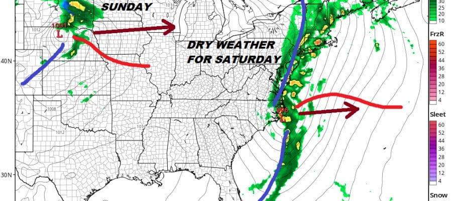
Two jets & two weather systems for Friday & Friday night. Things are slowing down in the atmosphere plus a warm front sets up to our south on Friday. Look for cloudy skies with some passing showers until the trough swings eastward and get into more numerous showers and the potential for some heavier downpours later Friday and Friday night.

As long as everything moves along weather conditions should improve on Saturday with sunshine returning and highs in the 60s to near 70. The pattern remains fast and another system follows out of the Plains and that one heads for the Great Lakes & New England on Sunday. This is another cold front for us. I’m thinking that Sunday will see clouds with some sun and the risk for late day showers and highs in the 70s. Early next week starts with a shot of cooler air. Sunshine returns with highs Monday in the low to mid 60s. The longer range shows a ridge building in the Eastern US which would lead to warmer than normal conditions however what we can’t see is whether this will come with surface set ups that favor cooler air and being dominated by an onshore flow (wind off the ocean) It is all fine and dandy to have a warm pattern aloft but we don’t live aloft. Often times in the spring what is going on upstairs and what is going on downstairs are two different things. We will examine this in the long range later today.
MANY THANKS TO TROPICAL TIDBITS FOR THE USE OF MAPS
Please note that with regards to any tropical storms or hurricanes, should a storm be threatening, please consult your local National Weather Service office or your local government officials about what action you should be taking to protect life and property.


