Sunshine Nice Thursday Next Front Friday Storm Develops Saturday

Weather in 5/Joe & Joe Weather Show Latest Podcast
Sunshine Nice Thursday Next Front Friday Storm Develops Saturday
The large upper air storm covering the Northeast has finally pulled away to the east and we are set for genuine improvement today. We should see mostly sunny skies with less wind and temperatures will bounce a little higher to the mid to upper 40s. Some warm spots could approach 50. Enjoy the day because the next round of changes begin on Friday which will lead to another storm headed our way for Saturday. There are no issues on the regional and local radars today or tonight. Temperatures tonight will bottom in the 30s with dry conditions.
SATELLITE

REGIONAL RADAR

Friday a weak front approaches with clouds increasing. The front passes and stalls offshore and then we being to see some rain develop along the frontal boundary during the afternoon. All of this is ahead of a developing storm headed out of the Southern Plains and the turning northeast up the East Coast for Saturday.

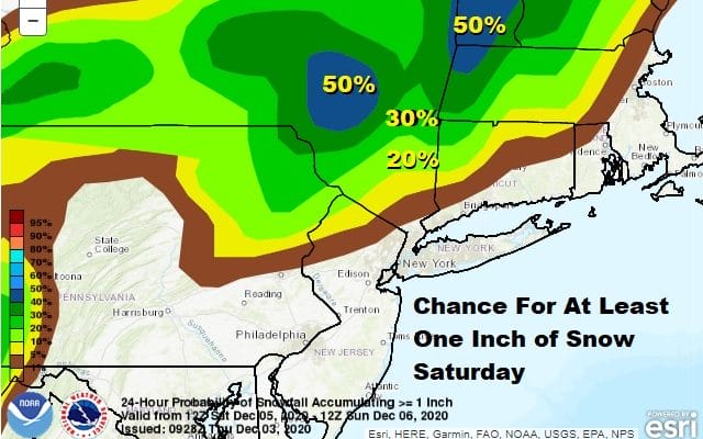
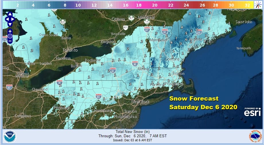
Rain will increase in coverage and intensity Friday night into Saturday as the low strengthens. The tough part of the forecast is whether the southern system phases efficiently to bring some cold air into the mix, changing the rain over to snow across the Catkskills, Poconos, the Hudson Valley and Southern New England, perhaps even down to Long Island and NYC during Saturday.

Rainfall amounts will be on the order of 1 to 2 inches in most places from Delmarva to Southeastern New England. Snow forecasts bring the chance for an inch of snow down to about Route 84. Saturday will see temperatures settle in the 30s in most places before the day is done.
The storm moves away Saturday night and weather conditions improve Sunday with some sunshine and a gusty wind with highs just in the 40s. Next week appears to be dry and uneventful with some sunshine each day. Wednesday sees a weak cold front move through with a rain or snow shower otherwise there are no storm systems on tap for the week ahead.
BE SURE TO DOWNLOAD THE FREE METEOROLOGIST JOE CIOFFI WEATHER APP &
ANGRY BEN’S FREE WEATHER APP “THE ANGRY WEATHERMAN!
MANY THANKS TO TROPICAL TIDBITS FOR THE USE OF MAPS
Please note that with regards to any severe weather, tropical storms, or hurricanes, should a storm be threatening, please consult your local National Weather Service office or your local government officials about what action you should be taking to protect life and property.


