Sunny Chilly Saturday Cold Front Arrives Sunday Night
Thanksgiving Week Breezy Chilly

Weather in 5/Joe & Joe Weather Show Latest Podcast
Sunny Chilly Saturday Cold Front Arrives Sunday Night
Thanksgiving Week Breezy Chilly

Our weekend begins and we have sunshine for our Saturday pretty much from start to finish. High pressure is right along the coast and is only very slowly moving east. Winds will be less of an issue today but temperatures won’t be fast to rise. Highs will reach the mid to upper 40s. The satellite view is clear in Eastern US today and the radar shows no precipitation echoes anywhere close by so enjoy your Saturday. Temperatures tonight won’t be as cold as this morning with most lows in the mid 30s to around 40 or so. Skies tonight will start off clear but look for clouds to roll in toward Sunday morning.
SATELLITE

WEATHER RADAR

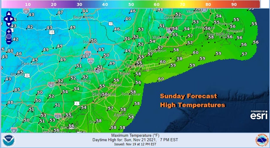
Sunday we will see warmer temperatures and clouds slowly increase and a cold front draws closer. I still believe we should not see any showers during the dayside Sunday. Highs will be mostly in the 50s.
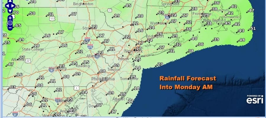
The cold front will move through Sunday night but as we have gotten closer and closer to this frontal passage the weaker and weaker it looks. We will see some rain overnight into early Monday morning but rainfall amounts will be generally under a quarter of an inch.

The blocking pattern in the Atlantic continues to develop but it seems everything will be a little further to the east. We though that the one issue this week would be wind along the coast giving us breezy to windy weather conditions through Thursday. Even here we have seen models dial the wind issues down. So once the rain ends Monday morning we will see leftover clouds giving way to some clearing later in the day. We will have some gusty northwest winds but nothing extraordinary. Temperatures will top in the 50s before easing later in the day.

Tuesday morning will be a cold one with most lows in the mid 20s to lower 30s. Tuesday dayside will be no worse than partly sunny but it will be breezy and cold with highs just back into the lower 40s in most places.

Wednesday will be a sunny day with not issues for travelers getting away early. Highs will be in the middle to upper 40s. Thursday Thanksgiving Day will be a nice day of sunshine with temperatures back into the low and middle 50s. Friday brings another cold front with the chance for a couple of showers and then it turns colder and dry over the weekend. We seem to be moving away from any storminess and to more of a dry uneventful weather pattern to finish off the month of November.
BE SURE TO DOWNLOAD THE FREE METEOROLOGIST JOE CIOFFI WEATHER APP &
ANGRY BEN’S FREE WEATHER APP “THE ANGRY WEATHERMAN!

MANY THANKS TO TROPICAL TIDBITS & F5 WEATHER FOR THE USE OF MAPS
Please note that with regards to any severe weather, tropical storms, or hurricanes, should a storm be threatening, please consult your local National Weather Service office or your local government officials about what action you should be taking to protect life and property.


