Sunday Weather Improves Before Rains Move In
Sunday Weather Improves Before Rains Move In
The stalled front to our south is getting a little push from dry air to the north tonight. You can see on the satellite loop the fight going on between the dry air trying to push south and the moisture just stubbornly sitting across the Middle Atlantic States. Ultimately the dry air will win out on Sunday and force the frontal boundary further south. That should allow sunshine to develop for areas from Central New Jersey northward. The cloud line will remain close enough that if you are anywhere near it, you might be fighting it all day.
SATELLITE LOOP

REGIONAL RADAR

LOCAL RADAR NEW YORK CITY

LOCAL RADAR PHILADELPHIA


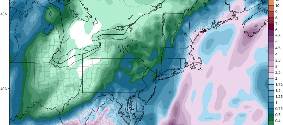
The moisture to the south will eventually start moving slowly northward on Monday as low pressure develops off the Southeast coast and starts to move up the Eastern seaboard. Skies will become overcast Monday with rain spreading northward across Southern Pennsylvania and New Jersey Monday and reaching New York City late in the day or Monday evening. Then Monday night into Tuesday night it will be rain with a northeast wind and raw conditions. Monday and Tuesday highs will probably be just in the 50s.
GFS FORECAST RAINFALL THROUGH WEDNESDAY NIGHT
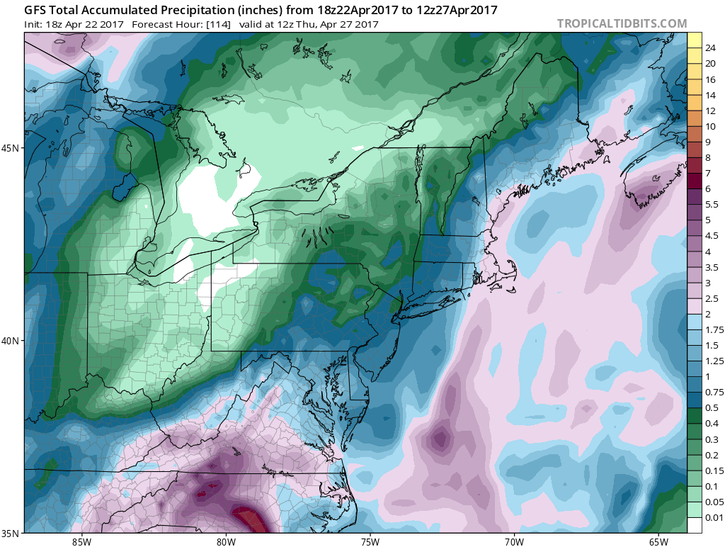
The system will spend most of it’s strength south from Virginia south into North Carolina where 4 inch plus rains are likely. We will see a long duration soaking rain that will produce anywhere from a 1/2 inch to an inch and a quarter. Weather conditions will start to improve on Wednesday though there may still be clouds and a few lingering showers in the mix. Warmer weather returns Thursday and Friday as warm high pressure aloft begins to build along the East coast.
 GET JOE A CIGAR IF YOU LIKE

LANDSCAPE COMPANIES FOR YOUR NEEDS
LONG ISLAND ROCKLAND COUNTY Connecticut

![]()

ROCKLAND COUNTY TRI STATE SNOW REMOVAL JOHNSTOWN PA


FiOS1 News Weather Forecast For Long Island
FiOS1 News Weather Forecast For New Jersey
FiOS1 News Weather Forecast For Hudson Valley
NATIONAL WEATHER SERVICE SNOW FORECASTS
LATEST JOESTRADAMUS ON THE LONG RANGE
Weather App

Don’t be without Meteorologist Joe Cioffi’s weather app. It is really a meteorologist app because you get my forecasts and my analysis and not some automated computer generated forecast based on the GFS model. This is why your app forecast changes every 6 hours. It is model driven with no human input at all. It gives you an icon, a temperature and no insight whatsoever.
It is a complete weather app to suit your forecast needs. All the weather information you need is right on your phone. Android or I-phone, use it to keep track of all the latest weather information and forecasts. This weather app is also free of advertising so you don’t have to worry about security issues with your device. An accurate forecast and no worries that your device is being compromised.
Use it in conjunction with my website and my facebook and twitter and you have complete weather coverage of all the latest weather and the long range outlook. The website has been redone and upgraded. Its easy to use and everything is archived so you can see how well Joe does or doesn’t do when it comes to forecasts and outlooks.
Just click on the google play button or the apple store button on the sidebar for my app which is on My Weather Concierge. Download the app for free. Subscribe to my forecasts on an ad free environment for just 99 cents a month.
Get my forecasts in the palm of your hand for less than the cost of a cup of Joe!


