Showers Moving Through On Radar
Showers Moving Through On Radar
This stubborn stalled front continues to cause problems and little ripples of low pressure are moving along it. Showers are on the radar this morning and it looks now that there will be some on and off showers into this afternoon at least before everything starts sinking southward. It is another rather ugly day from the standpoint of cloud cover as regardless of showers it will remain overcast pretty much all day long into this evening.
SATELLITE LOOP

REGIONAL RADAR

LOCAL RADAR NEW YORK CITY

LOCAL RADAR PHILADELPHIA


Once we get through this evening we should start to see some slow clearing from north to south as dry air moves down from the north. Temperatures today will be in the 50s to near 60 and lows tonight will be in the 40s. Sunday looks a little better with clouds and some sun with more sun as you go north and west of the coast into the Hudson Valley and Southern New England…clouds will probably be stubborn across Central and South Jersey and Southeastern Pennsylvania. Highs should reach the upper 50s to lower 60s.
Monday we will be watching low pressure developing off the southeast coast that will try and lift northward. It will only get so far north before it begins to weaken. However there should be a decent surge of rain with this beginning later Monday and lasting into Tuesday night.
GFS RAINFALL THROUGH WEDNESDAY MORNING
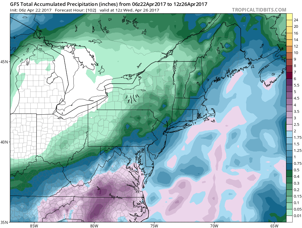
Rainfall amounts will be on the order of a 1/2 inch to 1.25 inches with more along the coast and less as you head north and west to inland areas. Once this event is done we will be setting up for warmer temperatures late this week.
 GET JOE A CIGAR IF YOU LIKE

LANDSCAPE COMPANIES FOR YOUR NEEDS
LONG ISLAND ROCKLAND COUNTY Connecticut

![]()

ROCKLAND COUNTY TRI STATE SNOW REMOVAL JOHNSTOWN PA


FiOS1 News Weather Forecast For Long Island
FiOS1 News Weather Forecast For New Jersey
FiOS1 News Weather Forecast For Hudson Valley
NATIONAL WEATHER SERVICE SNOW FORECASTS
LATEST JOESTRADAMUS ON THE LONG RANGE
Weather App

Don’t be without Meteorologist Joe Cioffi’s weather app. It is really a meteorologist app because you get my forecasts and my analysis and not some automated computer generated forecast based on the GFS model. This is why your app forecast changes every 6 hours. It is model driven with no human input at all. It gives you an icon, a temperature and no insight whatsoever.
It is a complete weather app to suit your forecast needs. All the weather information you need is right on your phone. Android or I-phone, use it to keep track of all the latest weather information and forecasts. This weather app is also free of advertising so you don’t have to worry about security issues with your device. An accurate forecast and no worries that your device is being compromised.
Use it in conjunction with my website and my facebook and twitter and you have complete weather coverage of all the latest weather and the long range outlook. The website has been redone and upgraded. Its easy to use and everything is archived so you can see how well Joe does or doesn’t do when it comes to forecasts and outlooks.
Just click on the google play button or the apple store button on the sidebar for my app which is on My Weather Concierge. Download the app for free. Subscribe to my forecasts on an ad free environment for just 99 cents a month.
Get my forecasts in the palm of your hand for less than the cost of a cup of Joe!


