Sunday Starts With Sunshine Clouds To The South Creep Northward

The second day of the weekend certainly starts off nice enough with sunshine just about everywhere. The nice strong high continues to slowly slide to the southeast and off the coat of Southern New England in a northwest/southeast fashion. This basically creates a wall of clouds across the Delmarva Peninsula that extends westward and then northwestward into Western Pennsylvania. We are stuck in between for much of today. The question of how far north do the clouds get is on the table and the creep northward should be a slow one. The cloud line should reach into Southern New Jersey and Southeastern Pennsylvania later today but -probably won’t get to Northern New Jersey to Southern New England until tonight. Temperatures today will be impacted by the wind from the east and cloud cover or lack there of so highs will be in the 70s for most places and 60s along the coast.
SATELLITE

REGIONAL RADAR

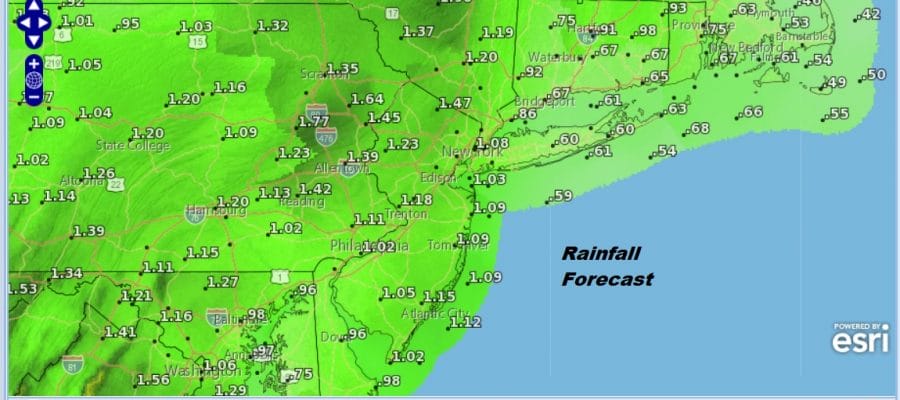
We really have nothing to worry about on the radar. Activity this morning is rather lacking through expect downpours to build up in Virginia today. Those downpours move northward overnight reaching Southern New Jersey and Southeastern Pennsylvania by midnight. Overnight and into Monday we will see bands of downpours moving northward. Some folks will get these while others may get less or miss out on one band only to be hit by the next. Watch the radars overnight and Monday. It will be all about timing. Temperatures overnight will be in the 60s. Highs Monday will be in the 70s with high humidity.
There will be breaks in between downpours with another round coming Monday night. This is a cold front that will be passing through. Watch for some thunderstorms in the mix as well. Rainfall amounts will exceed an inch in some places. It should be all done by daybreak Tuesday with improving weather conditions and sunshine developing. Highs Tuesday will be in the 70s.
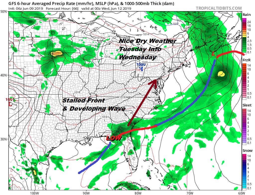
Monday’s weather system stalls out and another way develops and moves northward so look for sunshine to give way to arriving clouds on Wednesday with highs in the 70s. Then rain will move in sometime late Wednesday night or during the day Thursday with highs in the 60s to lower 70s. Once this system goes by it will set us up for a nice and warm Friday and Saturday. Next Sunday is Fathers’s Day. i have been leaning to the idea that it would be a nice three day stretch of weather that starts Friday and carries us through Sunday. However we could have another cold front bursting on the scene for Sunday to complicate matters. Nothing is written in stone in terms of specifics at this point.
MANY THANKS TO TROPICAL TIDBITS FOR THE USE OF MAPS
Please note that with regards to any tropical storms or hurricanes, should a storm be threatening, please consult your local National Weather Service office or your local government officials about what action you should be taking to protect life and property.


