Summer Winding Down
Summer Winding Down
No Important Pattern Changes
I look at Sunday being the first day of the week and I also look at the fact that the summer months are June July and August. Summer in my view ends on August 31 and meteorological fall begins on September 1st. Seasons do not switch on magical moments when the sun crosses the equator or reach their highest or lowest points in the sky.
With that said we are seeing a great second half to the weekend with lots of sunshine today.Temperatures will be in the 80s. Winds will be a little onshore-ish which probably keeps inland spots from reaching 90. The comfort level in my view is okay. The humidity is reasonable. Enjoy your Sunday. The satellite loop shows clear skies for the most part and no serious issues ahead for today or Monday.


Radar loops are quiet today. There are no serious issues regarding rain. We do have a weak cold front approaching on Monday. Ahead of it it will be like yesterday with sunshine, humidity a bit higher but not unreasonable. Temperatures Monday will be in the upper 80s to near 90.
Once that front goes by we have a shot of dry air for Tuesday with sunshine and highs in the low to mid 80s with low humidity. Then back up again Wednesday before a stronger shot of cooler air comes in for Thursday and Friday. We are also getting to the time of year where normals are dropping so it is going to get harder and harder for temperatures to get to 90 degrees. Warm ups between air masses will be lesser and lesser in magnitude. With regards to rain there is nothing in the cards through next weekend at least the way it looks at the moment. Models continue to be indecisive regarding low pressure in the Bahamas and low pressure off the Carolinas. It appears to me at the moment that neither even in the most aggressive model solution would bring rain here of significance anytime soon.
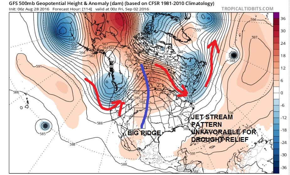
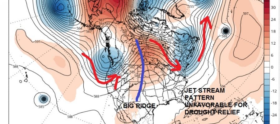
The long term jet stream pattern shows there is no real break in the dry pattern or hope for true drought relief. The flow is primarily from Canada and moisture sources are all cut off. Also if the tropics were to provide relief the jet stream pattern is all wrong for bringing tropical storms up the east coast.
FiOS1 News Weather Forecast For Long Island
FiOS1 News Weather Forecast For New Jersey
FiOS1 News Weather Forecast For Hudson Valley
NATIONAL WEATHER SERVICE SNOW FORECASTS
LATEST JOESTRADAMUS ON THE LONG RANGE
Weather App

Don’t be without Meteorologist Joe Cioffi’s weather app. It is really a meteorologist app because you get my forecasts and my analysis and not some automated computer generated forecast based on the GFS model. This is why your app forecast changes every 6 hours. It is model driven with no human input at all. It gives you an icon, a temperature and no insight whatsoever.
It is a complete weather app to suit your forecast needs. All the weather information you need is right on your phone. Android or I-phone, use it to keep track of all the latest weather information and forecasts. This weather app is also free of advertising so you don’t have to worry about security issues with your device. An accurate forecast and no worries that your device is being compromised.
Use it in conjunction with my website and my facebook and twitter and you have complete weather coverage of all the latest weather and the long range outlook. The website has been redone and upgraded. Its easy to use and everything is archived so you can see how well Joe does or doesn’t do when it comes to forecasts and outlooks.
Just click on the google play button or the apple store button on the sidebar for my app which is on My Weather Concierge. Download the app for free. Subscribe to my forecasts on an ad free environment for just 99 cents a month.
Get my forecasts in the palm of your hand for less than the cost of a cup of Joe!

MENTION JOE CIOFFI AND GET A 5% DISCOUNT


