
Summer Weekend Ahead Very Warm More Humid No Rain Until Monday

Summer Weekend Ahead Very Warm More Humid No Rain Until Monday
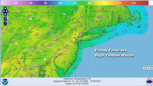
We have arrived to the end of the week and it was a bit of a strange weather week. Weather systems were moving in odd directions, north to south verses east to west. As always these unusual but not unheard of weather patterns don’t last long and the atmosphere stabilizes back to something more normal and that is exactly what is happening now. Weather systems are moving again. The satellite loop shows a storm well offshore movig northward toward Nova Scotia and drier air has returned. We are going to see sunshine today with reasonable temperatures and humidity. Highs will reach 80 to 85 and it is a solid way to finish off the week.
SATELLITE

WEATHER RADAR

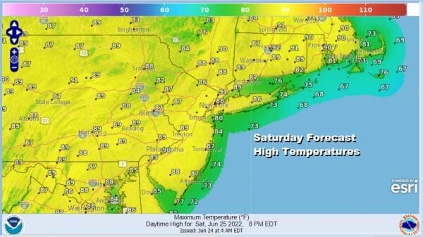
At least initially we have a low humidity scheme here and that should hold for tonight and probably most of Saturday. For Eastern Pennsylvania to Southern New England tonight will be mostly clear with lows in the upper 50s to mid 60s. Saturday will be a sunny day with warmer temperatures and while the humidity turns a little higher it still should be reasonable. Highs will reach the mid to upper 80s with one or two odd spots inland getting to 90. Sea breezes will develop locally at shore locations making it a little cooler.
Sunday we begin to see the turn to high humidity, higher temperatures and generally uncomfortable conditions. However in spite of the increase in moisture we have a very stable atmosphere so we will not see any showers or thunderstorms through the weekend. As for highs Sunday look for temperatures to reach 85 to 90 degrees in most places.
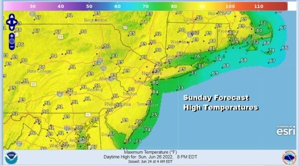
One or two hot spiots Sunday could reach 91 or 92. However these 90 degree days in this pattern are 1 or at most 2 day affairs and this is going to be no different. Monday brings the next round of changes. Our pattern is being controlled by a very vigorous upper air pattern across Canada that looks more like it does in May than the end of June.

This brings cold fronts through every 3 days or so meaning the atmosphere has no time to get hot in the Northeast. Just as it tries to do that, a cold front comes to cut it off and that happens Monday. A cold front will trigger showers and thunderstorms later in the day. More clouds will probably hold highs to low and middle 80s.

There is the possibility that one or two of those thunderstorms could be strong as the front passes. After that goes by we have a couple of dry days that follow and then another cold front late in the week. We do not see any type of blocking scenario where weather systems get stuck. As long as systems keep moving, it means most of the time it will be rain free except for the days when these weather fronts go by.
BE SURE TO DOWNLOAD THE FREE METEOROLOGIST JOE CIOFFI WEATHER APP &
ANGRY BEN’S FREE WEATHER APP “THE ANGRY WEATHERMAN!
MANY THANKS TO TROPICAL TIDBITS & F5 WEATHER FOR THE USE OF MAPS
Please note that with regards to any severe weather, tropical storms, or hurricanes, should a storm be threatening, please consult your local National Weather Service office or your local government officials about what action you should be taking to protect life and property.


