
Summer 2017 Missing In Action So Far

Summer 2017 Missing In Action So Far
If your definition of summer is endless days of 90 plus temperatures and obnoxious humidity then so far this summer you have been quite disappointed. Other than the two mini heatwaves we saw (Mid May, Mid June) the vast majority of days have actually been quite reasonable from the standpoint of temperature and humidity. What is going on during summer 2017? Well summer 2017 isn’t missing in action so much. It just decided to park itself in a different location.

The upper air jet stream forecast illustrates the pattern we have been in since late May. Summer 2017 has parked itself in the Western US where a strong ridge has settled there and shows little signs of moving. Occasionally it noses eastward and then goes right back to the west. This is because we continue to see the jet stream trough in the east. This brings the flow out of Canada. Every time the trough lifts out, another one follows. The result is cold fronts coming through every 3 or 4 day. It gets very warm to hot for a day or so and then the dry cooler air from the north takes over. This has been the signature of the weather pattern in the East for the last 6 or 7 weeks and it shows no signs of changing anytime in the short range.
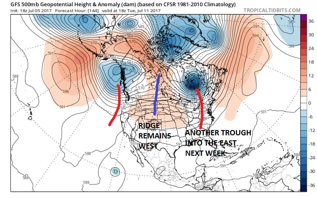
Even when the weekend trough lifts out another one replaces it for the middle of next week. The ridge in the west flattens a little but it still remains essentially in the west. For it to get hot here for a long period of time, that ridge needs to develop in the east with a trough in the west. For now that pattern remains elusive. How does this measure up in terms of temperatures?

You can see the consequences of this pattern with the map above showing temperature departures from average. This map is for next Sunday evening. Notice that temperatures throughout the Eastern half of the US are below average while the western part of North America shows temperatures well above average. Up until now the ridge in the east seems to appear for a few days every 4 weeks or so. Each time that ridge shows up it hangs for shorter and shorter time frames. I suspect we may say another ridge pop up in the east at some point this month though the signs now are few and far between.
One of the other things to consider is if the trough in the East continues to be persistent, that could become important as we get deeper into Hurricane Season. The trough in the East could open the door for something to come up the east coast but if the trough is too far east, it can also act as the broom to sweep storms out to sea. I’ve always thought it best to deal with patterns in terms of the trend being your friend until the trend changes. So until we see the ridge in the Western US break down, heatwaves and days of intolerable humidity won’t last very long.
This video explains the short and long range further along with the latest on the Tropics.
MANY THANKS TO TROPICAL TIDBITS FOR THE WONDERFUL USE OF THE MAPS

GET JOE A CIGAR IF YOU LIKE!
LANDSCAPE COMPANIES FOR YOUR SPRING SUMMER FALL NEEDS
LONG ISLAND ROCKLAND COUNTY Connecticut

![]()

ROCKLAND COUNTY TRI STATE SNOW REMOVAL JOHNSTOWN PA


FiOS1 News Weather Forecast For Long Island
FiOS1 News Weather Forecast For New Jersey
FiOS1 News Weather Forecast For Hudson Valley
NATIONAL WEATHER SERVICE SNOW FORECASTS
LATEST JOESTRADAMUS ON THE LONG RANGE
Weather App

Don’t be without Meteorologist Joe Cioffi’s weather app. It is really a meteorologist app because you get my forecasts and my analysis and not some automated computer generated forecast based on the GFS model. This is why your app forecast changes every 6 hours. It is model driven with no human input at all. It gives you an icon, a temperature and no insight whatsoever.
It is a complete weather app to suit your forecast needs. All the weather information you need is right on your phone. Android or I-phone, use it to keep track of all the latest weather information and forecasts. This weather app is also free of advertising so you don’t have to worry about security issues with your device. An accurate forecast and no worries that your device is being compromised.
Use it in conjunction with my website and my facebook and twitter and you have complete weather coverage of all the latest weather and the long range outlook. The website has been redone and upgraded. Its easy to use and everything is archived so you can see how well Joe does or doesn’t do when it comes to forecasts and outlooks.
Just click on the google play button or the apple store button on the sidebar for my app which is on My Weather Concierge. Download the app for free. Subscribe to my forecasts on an ad free environment for just 99 cents a month.
Get my forecasts in the palm of your hand for less than the cost of a cup of Joe!
![]()
