Subtropical Depression One Forms In Central Atlantic
Subtropical Depression One Forms In Central Atlantic
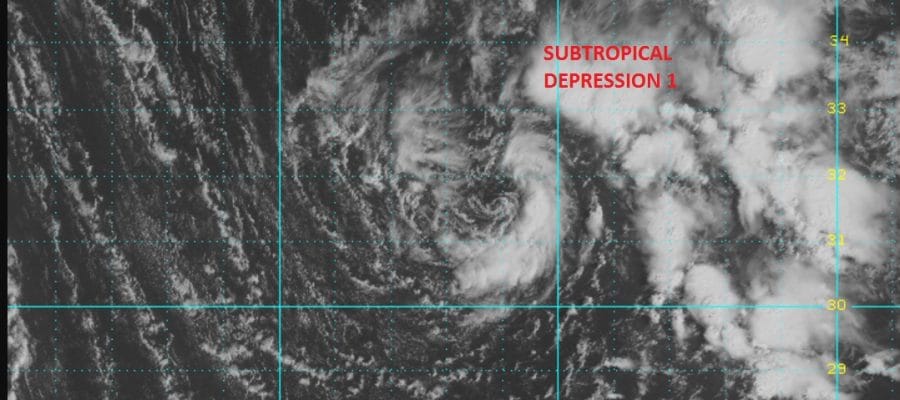
We have a subtropical depression that has formed well out in the Central Atlantic this morning. This has formed from a non tropical low that has been out in the Atlantic for the last few days. A core of convection has formed near the circulation center and it was enough for the National Hurricane Center to upgrade this to a subtropical depression. No strengthening is forecast due to cold waters and a strong shearing environment. The system is forecast to be absorbed by a non tropical low over the next 2 days or so. It is very unusual to see something like this in mid April though not unheard of. Tropical Storm Ana in 2003 formed in April and affected Florida with wind and rain. Here is a link to a list of off season tropical systems

ULLETIN
Subtropical Depression One Advisory Number   1
NWS National Hurricane Center Miami FL       AL012017
1100 AM AST Wed Apr 19 2017

...SUBTROPICAL DEPRESSION FORMS IN THE CENTRAL ATLANTIC...
...EXPECTED TO BE SHORT LIVED...


SUMMARY OF 1100 AM AST...1500 UTC...INFORMATION
-----------------------------------------------
LOCATION...31.9N 40.9W
ABOUT 890 MI...1435 KM WSW OF THE AZORES
MAXIMUM SUSTAINED WINDS...35 MPH...55 KM/H
PRESENT MOVEMENT...NNE OR 30 DEGREES AT 8 MPH...13 KM/H
MINIMUM CENTRAL PRESSURE...995 MB...29.39 INCHES


WATCHES AND WARNINGS
--------------------
There are no coastal watches or warnings in effect.


DISCUSSION AND 48-HOUR OUTLOOK
------------------------------
At 1100 AM AST (1500 UTC), the center of Subtropical Depression One
was located near latitude 31.9 North, longitude 40.9 West. The
subtropical depression is moving toward the north-northeast near 8
mph (13 km/h). A gradual turn to the north is expected tonight.

Maximum sustained winds are near 35 mph (55 km/h) with higher gusts.
Little change in strength is forecast today, and the subtropical
depression is forecast to become absorbed by a large extratropical
low on Thursday.

The estimated minimum central pressure is 995 mb (29.39 inches).

MANY THANKS TO TROPICAL TIDBITS FOR THE WONDERFUL USE OF THE MAPS
WINTER 2016-2017 PART 1 OCEAN WATER TEMPERATURES
WINTER 2016-2017 PART 2 ARCTIC SEA ICE AND SIBERIAN SNOW COVER
WINTER 2016-2017 PART 3 NEW JERSEY PREVIEW
WINTER 2016-2017 PART 4 EASTERN PENNSYLVANIA PREVIEW
FiOS1 News Weather Forecast For Long Island
FiOS1 News Weather Forecast For New Jersey
FiOS1 News Weather Forecast For Hudson Valley
NATIONAL WEATHER SERVICE SNOW FORECASTS
LATEST JOESTRADAMUS ON THE LONG RANGE
Weather App

Don’t be without Meteorologist Joe Cioffi’s weather app. It is really a meteorologist app because you get my forecasts and my analysis and not some automated computer generated forecast based on the GFS model. This is why your app forecast changes every 6 hours. It is model driven with no human input at all. It gives you an icon, a temperature and no insight whatsoever.
It is a complete weather app to suit your forecast needs. All the weather information you need is right on your phone. Android or I-phone, use it to keep track of all the latest weather information and forecasts. This weather app is also free of advertising so you don’t have to worry about security issues with your device. An accurate forecast and no worries that your device is being compromised.
Use it in conjunction with my website and my facebook and twitter and you have complete weather coverage of all the latest weather and the long range outlook. The website has been redone and upgraded. Its easy to use and everything is archived so you can see how well Joe does or doesn’t do when it comes to forecasts and outlooks.
Just click on the google play button or the apple store button on the sidebar for my app which is on My Weather Concierge. Download the app for free. Subscribe to my forecasts on an ad free environment for just 99 cents a month.
Get my forecasts in the palm of your hand for less than the cost of a cup of Joe!
![]()
![]()