Strong Thunderstorms Moving East
Strong Thunderstorms Moving East
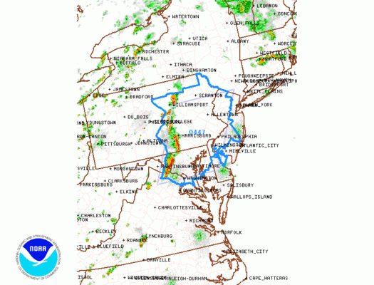
Severe Thunderstorm Watch Northwest and
Western New Jersey Eastern Pennsylvania
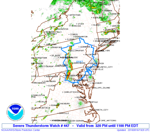
SEVERE THUNDERSTORM WATCH OUTLINE UPDATE FOR WS 447
NWS STORM PREDICTION CENTER NORMAN OK
320 PM EDT TUE AUG 16 2016

SEVERE THUNDERSTORM WATCH 447 IS IN EFFECT UNTIL 1100 PM EDT
FOR THE FOLLOWING LOCATIONS

PAC001-011-017-025-029-037-041-043-045-067-069-071-075-077-079-
081-089-091-093-095-097-099-101-103-107-109-113-119-131-133-
170300-
/O.NEW.KWNS.SV.A.0447.160816T1920Z-160817T0300Z/

PA
.    PENNSYLVANIA COUNTIES INCLUDED ARE

ADAMS                BERKS               BUCKS
CARBON               CHESTER             COLUMBIA
CUMBERLAND           DAUPHIN             DELAWARE
JUNIATA              LACKAWANNA          LANCASTER
LEBANON              LEHIGH              LUZERNE
LYCOMING             MONROE              MONTGOMERY
MONTOUR              NORTHAMPTON         NORTHUMBERLAND
PERRY                PHILADELPHIA        PIKE
SCHUYLKILL           SNYDER              SULLIVAN
UNION                WYOMING             YORK
$$
SEVERE THUNDERSTORM WATCH OUTLINE UPDATE FOR WS 447
NWS STORM PREDICTION CENTER NORMAN OK
320 PM EDT TUE AUG 16 2016

SEVERE THUNDERSTORM WATCH 447 IS IN EFFECT UNTIL 1100 PM EDT
FOR THE FOLLOWING LOCATIONS

NJC005-007-015-019-021-027-033-035-037-041-170300-
/O.NEW.KWNS.SV.A.0447.160816T1920Z-160817T0300Z/

NJ
.    NEW JERSEY COUNTIES INCLUDED ARE

BURLINGTON           CAMDEN              GLOUCESTER
HUNTERDON            MERCER              MORRIS
SALEM                SOMERSET            SUSSEX
WARREN
$$
We have a line of strong thunderstorms moving across East Central Pennsylvania and heading fairly quickly to the east. The line seems to be holding together. We remain at a slight risk for severe. A second line is developing in Western Pennsylvania and if that lines hold together it won’t get here until after 9 or 10pm. The big question is whether these thunderstorms hold up as they move east.


The narrow line shows up well on the regional radar and it was not showing to any great degree by any of the short term models which have been handling thunderstorm situations badly over the last week or so. We will continue to follow these along as they move east. If that first line holds together, it would probably reach Western New Jersey between 5 and 6pm.
Strong Thunderstorms Moving East Regional Radar

Strong Thunderstorms Moving East Local Radars


FiOS1 News Weather Forecast For Long Island
FiOS1 News Weather Forecast For New Jersey
FiOS1 News Weather Forecast For Hudson Valley
NATIONAL WEATHER SERVICE SNOW FORECASTS
LATEST JOESTRADAMUS ON THE LONG RANGE
Weather App

Don’t be without Meteorologist Joe Cioffi’s weather app. It is really a meteorologist app because you get my forecasts and my analysis and not some automated computer generated forecast based on the GFS model. This is why your app forecast changes every 6 hours. It is model driven with no human input at all. It gives you an icon, a temperature and no insight whatsoever.
It is a complete weather app to suit your forecast needs. All the weather information you need is right on your phone. Android or I-phone, use it to keep track of all the latest weather information and forecasts. This weather app is also free of advertising so you don’t have to worry about security issues with your device. An accurate forecast and no worries that your device is being compromised.
Use it in conjunction with my website and my facebook and twitter and you have complete weather coverage of all the latest weather and the long range outlook. The website has been redone and upgraded. Its easy to use and everything is archived so you can see how well Joe does or doesn’t do when it comes to forecasts and outlooks.
Just click on the google play button or the apple store button on the sidebar for my app which is on My Weather Concierge. Download the app for free. Subscribe to my forecasts on an ad free environment for just 99 cents a month.
Get my forecasts in the palm of your hand for less than the cost of a cup of Joe!

MENTION JOE CIOFFI AND GET A 5% DISCOUNT