
Storm Warning Coastal Flood High Wind Watch
WEATHER VIDEO…WHAT YOU CAN EXPECT OVER THE NEXT FEW DAYS
HOW WILL THE NOREASTER PLAY OUT
Storm Warning Coastal Flood High Wind Watch
STORM WARNINGS ARE IN EFFECT FOR THE COASTAL WATERS
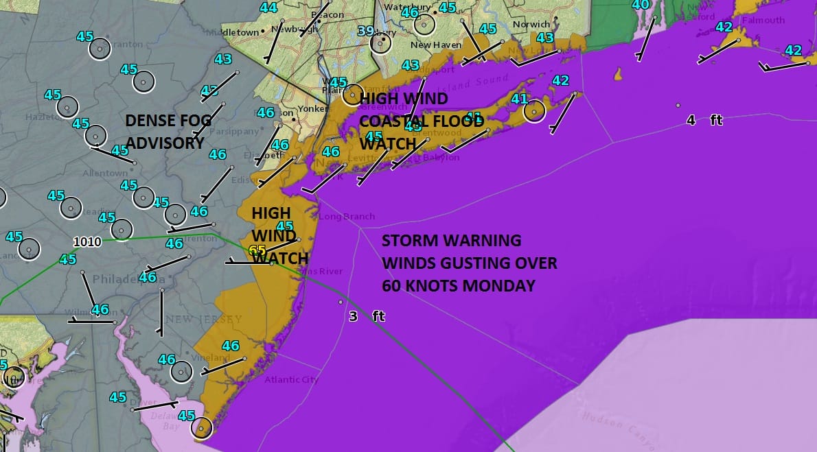
* WINDS AND SEAS...EAST WINDS 35 TO 45 KT WITH GUSTS 50 TO 60 KT.
  SEAS 17 TO 22 FEET.

* VISIBILITY...1 NM OR LESS THROUGH EARLY SUNDAY MORNING.

PRECAUTIONARY/PREPAREDNESS ACTIONS...

A STORM WARNING MEANS SUSTAINED WINDS OR FREQUENT GUSTS OF 48 TO
63 KT ARE EXPECTED OR OCCURRING. RECREATIONAL BOATERS SHOULD
REMAIN IN PORT...OR TAKE SHELTER UNTIL WINDS AND WAVES SUBSIDE.
COMMERCIAL VESSELS SHOULD PREPARE FOR VERY STRONG WINDS AND
DANGEROUS SEA CONDITIONS...AND CONSIDER REMAINING IN PORT OR
TAKING SHELTER IN PORT UNTIL WINDS AND WAVES SUBSIDE.

A DENSE FOG ADVISORY MEANS VISIBILITIES WILL FREQUENTLY BE
REDUCED TO LESS THAN ONE MILE. INEXPERIENCED MARINERS...
ESPECIALLY THOSE OPERATING SMALLER VESSELS SHOULD AVOID
NAVIGATING IN THESE CONDITIONS.
COASTAL FLOOD WATCH FOR LONG ISLAND
..MODERATE COASTAL FLOODING POSSIBLE MONDAY EVENING...
...WIDESPREAD DUNE EROSION AND LOCALIZED WASHOVERS FOR ATLANTIC
OCEAN BEACHFRONT MONDAY INTO TUESDAY...

NYZ079>081-179-221030-
/O.COR.KOKX.CF.A.0001.170123T2000Z-170124T0300Z/
NORTHEASTERN SUFFOLK-SOUTHWESTERN SUFFOLK-SOUTHEASTERN SUFFOLK-
SOUTHERN NASSAU-
527 PM EST SAT JAN 21 2017

...COASTAL FLOOD WATCH IN EFFECT FROM MONDAY AFTERNOON THROUGH
MONDAY EVENING...

THE NATIONAL WEATHER SERVICE IN UPTON HAS ISSUED A COASTAL FLOOD
WATCH...WHICH IS IN EFFECT FROM MONDAY AFTERNOON THROUGH MONDAY
EVENING.

* LOCATIONS...ALONG SOUTHERN AND EASTERN BAYS OF LONG
  ISLAND...AND ALONG THE ATLANTIC OCEAN BEACHES.

* TIDAL DEPARTURES...3 1/2 TO 4 1/2 FT ABOVE ASTRONOMICAL TIDES.

* TIMING...MODERATE COASTAL FLOODING AROUND THE TIMES OF
  ASTRONOMICAL HIGH TIDE...BETWEEN 4 PM AND 9 PM. THERE IS A LOW
  PROBABILITY FOR MAJOR FLOOD THRESHOLDS TO BE REACHED IN ISOLATED
  SPOTS.

* BEACH EROSION IMPACTS...ELEVATED WATER LEVELS IN COMBINATION
  WITH 8 TO 12 FT SURF ARE EXPECTED TO CAUSE WIDESPREAD DUNE
  EROSION AND LOCALIZED OVERWASHES ALONG THE ATLANTIC OCEAN
  BEACHFRONT LATE SUNDAY NIGHT INTO TUESDAY.

* TIDAL IMPACTS...POTENTIAL FOR WIDESPREAD FLOODING OF VULNERABLE
  SHORE ROADS AND/OR ADJACENT PROPERTIES DUE TO HEIGHT OF STORM
  TIDE AND/OR WAVE ACTION. NUMEROUS ROAD CLOSURES MAY BE NEEDED.
  ISOLATED STRUCTURAL DAMAGE MAY BE OBSERVED ALONG THE IMMEDIATE
  SHORELINE.

PRECAUTIONARY/PREPAREDNESS ACTIONS...

A COASTAL FLOOD WATCH MEANS THAT CONDITIONS FAVORABLE FOR
FLOODING ARE EXPECTED TO DEVELOP. COASTAL RESIDENTS SHOULD BE
ALERT FOR LATER STATEMENTS OR WARNINGS...AND TAKE ACTION TO
PROTECT PROPERTY.

&&

...NASSAU COUNTY SOUTH SHORE BAY WATER LEVELS FOR MONDAY EVENING...

COASTAL............TIME OF......FORECAST TOTAL.......FLOOD.....
LOCATION...........HIGH TIDE.....WATER LEVEL.........CATEGORY..
...................................(MLLW/NGVD).................

FREEPORT GAUGE NY....514 PM.....6.1-6.6/5.3-5.8......MOD-MAJ...
POINT LOOKOUT NY.....417 PM.....6.5-7.0/5.4-5.9......MODERATE..
E ROCKAWAY NY........430 PM.....6.8-7.3/5.3-5.8......MODERATE..

...SUFFOLK COUNTY SOUTH SHORE BAY WATER LEVELS FOR MONDAY EVENING...

COASTAL............TIME OF......FORECAST TOTAL.......FLOOD.....
LOCATION...........HIGH TIDE.....WATER LEVEL.........CATEGORY..
...................................(MLLW/MHHW).................

LINDENHURST NY.......657 PM.....4.0-4.5/2.5-3.0......MOD-MAJ...

...EASTERN WATER LEVELS FOR MONDAY EVENING...

COASTAL............TIME OF......FORECAST TOTAL.......FLOOD.....
LOCATION...........HIGH TIDE.....WATER LEVEL.........CATEGORY..
...................................(MLLW/MHHW).................

MONTAUK NY..........558 PM......4.3-4.8/1.8-2.3......MINOR.....
ORIENT POINT NY.....709 PM......5.0-5.5/2.1-2.6......MINOR.....
RIVERHEAD NY........906 PM......6.1-6.6/2.8-3.3......MODERATE..
There have been no important changes in the outlook for Sunday night into Tuesday morning as a noreaster heads our way. Weather models this afternoon are pretty much on course. Low pressure will be coming across the Northern Gulf States on Sunday and then off the VIrginia/ North Carolina Coast later Monday. The strongest winds area forecast to begin late Sunday night and last into Monday evening. Areas to the south will start to see the winds diminsh later Monday afternoon while on Long Island and Southern New England it will be later Monday evening.
SATELLITE LOOP

Regional radar is showing the lead area of low pressure moving northeastward. Much of that rain should pass to the south. Rain will probably move into parts of Central and Southern New Jersey overnight into Sunday morning. However the main storm comes Sunday night into Monday night.
REGIONAL RADAR

LOCAL RADAR NEW YORK CITY

LOCAL RADAR PHILADELPHIA


As far as the rest of tonight and the daytime Sunday are concerned we have a Dense Fog Advisory up for the overnight into Sunday morning. No storm issues will occur through the daytime Sunday. Winds will increase and rain will arrive during Sunday night. From Late Sunday night through Monday evening we will see the worst of this with winds gusting to 50-60 mph along the coast and moderate to heavy rain.
SNOW REMOVAL COMPANIES FOR YOUR WINTER NEEDS
LONG ISLAND ROCKLAND COUNTY Connecticut

![]()

ROCKLAND COUNTY TRI STATE SNOW REMOVAL JOHNSTOWN PA


FiOS1 News Weather Forecast For Long Island
FiOS1 News Weather Forecast For New Jersey
FiOS1 News Weather Forecast For Hudson Valley
NATIONAL WEATHER SERVICE SNOW FORECASTS
LATEST JOESTRADAMUS ON THE LONG RANGE
Weather App

Don’t be without Meteorologist Joe Cioffi’s weather app. It is really a meteorologist app because you get my forecasts and my analysis and not some automated computer generated forecast based on the GFS model. This is why your app forecast changes every 6 hours. It is model driven with no human input at all. It gives you an icon, a temperature and no insight whatsoever.
It is a complete weather app to suit your forecast needs. All the weather information you need is right on your phone. Android or I-phone, use it to keep track of all the latest weather information and forecasts. This weather app is also free of advertising so you don’t have to worry about security issues with your device. An accurate forecast and no worries that your device is being compromised.
Use it in conjunction with my website and my facebook and twitter and you have complete weather coverage of all the latest weather and the long range outlook. The website has been redone and upgraded. Its easy to use and everything is archived so you can see how well Joe does or doesn’t do when it comes to forecasts and outlooks.
Just click on the google play button or the apple store button on the sidebar for my app which is on My Weather Concierge. Download the app for free. Subscribe to my forecasts on an ad free environment for just 99 cents a month.
Get my forecasts in the palm of your hand for less than the cost of a cup of Joe!


