Storm Threat Looms Sunday-Tuesday
NOREASTER STORM THREAT EARLY NEXT WEEK VIDEO ANALYSIS

Storm Threat Looms Sunday-Tuesday
Noreaster Threat Heavy Rain & Wind…Snow Well North
Models have been trending toward the idea of a noreaster effect the Middle Atlantic and Northeast for late Sunday and lasting into Tuesday. This is probably going to be the strongest storm we have seen here since the Blizzard from almost a year ago to the day. The difference this time is that there is no real cold air except in areas to the north. Models attempt to bleed some cold air southward at low levels but at the moment it is not enough to make a real difference unless you are well north of Route 84 in New York State and in New England.
STORM THREAT EUROPEAN MODEL UPPER AIR FORECAST CLICK TO ANIMATE
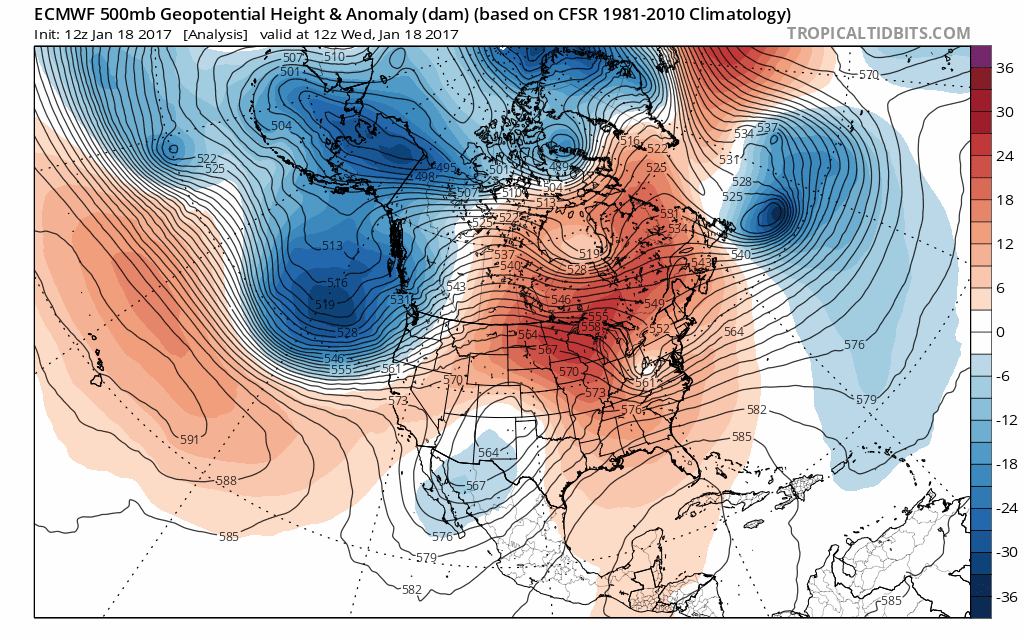
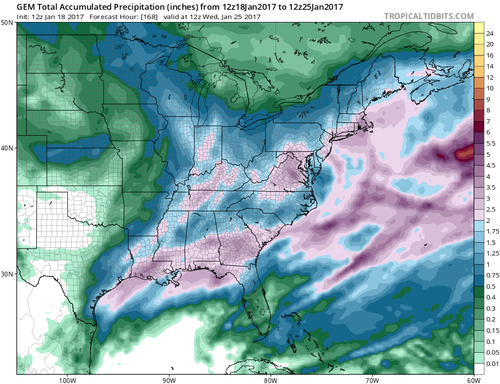
This is an impressive set up for the East Coast. A large blocking high is sitting to the north in Eastern Canada which forces the jet stream to lie south of its average position. This creates low pressure in the Southern states that moves east and then east northeast. The energy aloft with the southern system is substantial and will generate some very heavy rains up and down the East Coast that will make a serious dent in the drought.
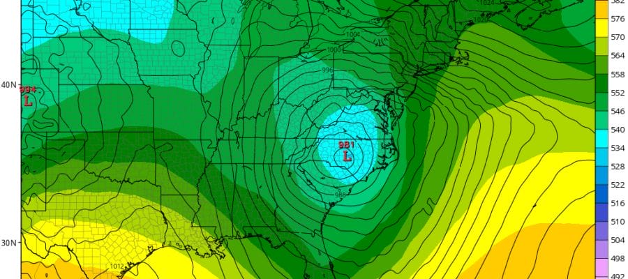
STORM THREAT EUROPEAN MONDAY MORNING
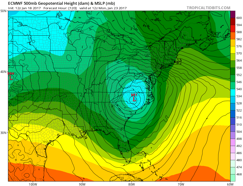
Strong high pressure lies to the north northeast of the storm which will lift northeastard from here. The pressure gradient is extremely tight which means strong winds are likely from the East or East southeast initially and then going around to the northeast over time. Winds will be gale force beginning Sunday night and lasting through Monday. Rains could be at least on the order of several inches or more.
Now the big question. There is cold air to the north. All the models show some of that cold air attempting to bleed southward with the Canadian model the furthest south bringing sleet and wet snow as far south as Northern New Jersey, Southern Westchester, and Southern Connecticut and Northeast Pennsylvania.
STORM THREAT WILL COLD AIR BLEED SOUTH CANADIAN VIEW
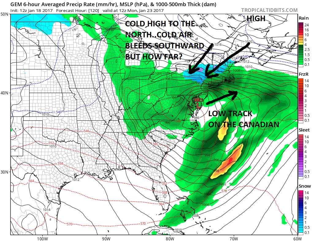
The Canadian model has the most aggressive view of this. Right now we area in watching mode with this. The other models have the same idea to different degrees. The GFS model has snow at the start in about the same areas as the Canadian produces accumulation snow/sleet. For now this is going to be treated as a rain event and we will watch to see what subsequent model runs do with all this.
MANY THANKS TO TROPICAL TIDBITS FOR THE WONDERFUL USE OF THE MAPS
SNOW REMOVAL COMPANIES FOR YOUR WINTER NEEDS
LONG ISLAND ROCKLAND COUNTY Connecticut

![]()

ROCKLAND COUNTY TRI STATE SNOW REMOVAL JOHNSTOWN PA


FiOS1 News Weather Forecast For Long Island
FiOS1 News Weather Forecast For New Jersey
FiOS1 News Weather Forecast For Hudson Valley
NATIONAL WEATHER SERVICE SNOW FORECASTS
LATEST JOESTRADAMUS ON THE LONG RANGE
Weather App

Don’t be without Meteorologist Joe Cioffi’s weather app. It is really a meteorologist app because you get my forecasts and my analysis and not some automated computer generated forecast based on the GFS model. This is why your app forecast changes every 6 hours. It is model driven with no human input at all. It gives you an icon, a temperature and no insight whatsoever.
It is a complete weather app to suit your forecast needs. All the weather information you need is right on your phone. Android or I-phone, use it to keep track of all the latest weather information and forecasts. This weather app is also free of advertising so you don’t have to worry about security issues with your device. An accurate forecast and no worries that your device is being compromised.
Use it in conjunction with my website and my facebook and twitter and you have complete weather coverage of all the latest weather and the long range outlook. The website has been redone and upgraded. Its easy to use and everything is archived so you can see how well Joe does or doesn’t do when it comes to forecasts and outlooks.
Just click on the google play button or the apple store button on the sidebar for my app which is on My Weather Concierge. Download the app for free. Subscribe to my forecasts on an ad free environment for just 99 cents a month.
Get my forecasts in the palm of your hand for less than the cost of a cup of Joe!
![]()
