Stalled Front Splits Area Cool Northeast Warm Southwest Thunderstorms

Weather in 5/Joe & Joe Weather Show Latest Podcast
Stalled Front Splits Area Cool Northeast Warm Southwest Thunderstorms
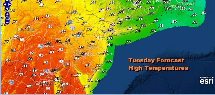
Overnight showers and downpours have now moved away to the east but it has left us in a bit of a dilemma behind the front today. The surface map this morning shows a stalled front cutting Eastern Pennsylvania to Southern New England in half. To the north we have lots of clouds with a northeast wind still hanging on. To the south of the front we have west or northwest winds which will allow skies to go partly sunny as the day wears on. This will mean a wide range in temperatures for highs today.
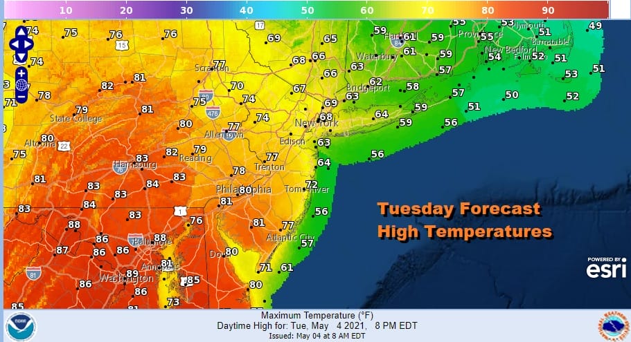
From Northeast Pennsylvania and Central New Jersey southward we will have highs reaching 80 or better. In fact further south into Maryland and Northern Virginia we could see highs reach the mid to upper 80s. However From Northern New Jersey to the Hudson Valley to Southwest Connecticut and Long Island highs will be struggling through the 60s and further east into Southeastern New England it will be a raw day with highs in the 50s. It is all about location today.
SATELLITE

There will be some scattered showers around today in the mix and late today and tonight look for some scattered showers and even a couple of thunderstorms as temperatures hold in the 50s to around 60. The threat for showers or a thunderstorm will last into Wednesday morning until a cold front passes around midday. There is a marginal risk of severe weather Wednesday from Southern New Jersey southward but by afternoon the northwest wind should freshen up with leftover clouds. Highs Wednesday will be in the upper 60s to mid 70s. Breezy conditions will continue Wednesday night with most lows in the 40s. Thursday shapes up to be the best day of the week with partly to mostly sunny skies but it will be on the cool side with highs just in the 60s.
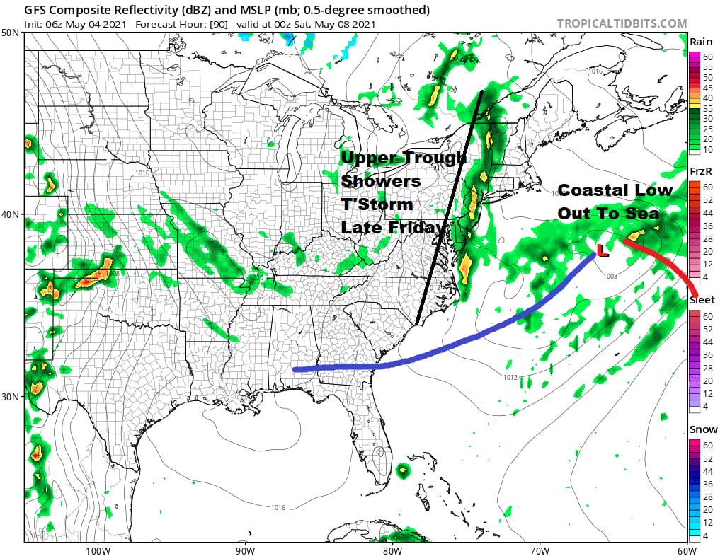
Friday we have a low that forms off the North Carolina coast and moves quickly to the northeast. It completely misses getting energized by an upper trough approach the coast late Friday but that trough could set off some showers and perhaps a thunderstorm late in the day. Highs will be just into the 60s. Then we head into the weekend.
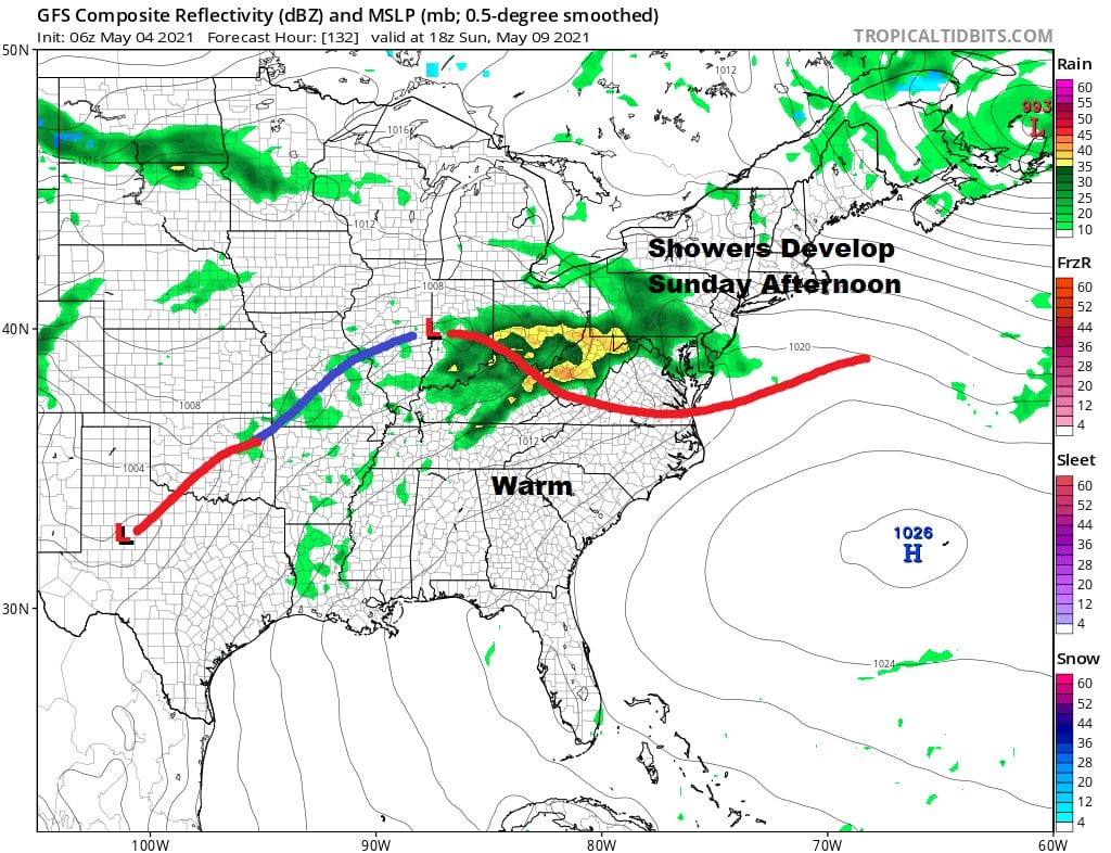
Saturday is now looking better than Sunday. It will be dry with some sunshine as we will have a low to the northeast and one to the west and we will be between the two. It will be cool though with highs just into the low and mid 60s. Sunday is Mother’s Day and while the morning will be dry, low pressure to the west and a stalled frontal boundary to our south will bring increasing clouds and then the chance for showers developing Sunday afternoon from west to east. Highs will just be in the 60s. Below average temperartures continue next week as another wave arrives later Monday with more rain into Monday night. Tuesday and Wednesday look to be dry and cool.

BE SURE TO DOWNLOAD THE FREE METEOROLOGIST JOE CIOFFI WEATHER APP &
ANGRY BEN’S FREE WEATHER APP “THE ANGRY WEATHERMAN!
MANY THANKS TO TROPICAL TIDBITS FOR THE USE OF MAPS
Please note that with regards to any severe weather, tropical storms, or hurricanes, should a storm be threatening, please consult your local National Weather Service office or your local government officials about what action you should be taking to protect life and property.


