Springlike Weekend Ahead
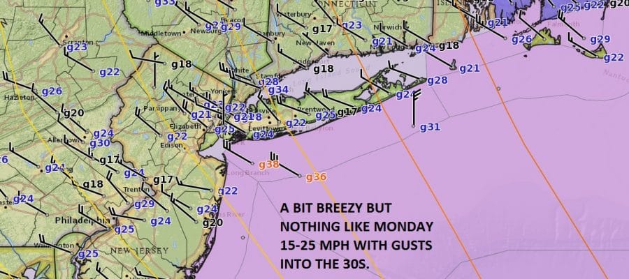
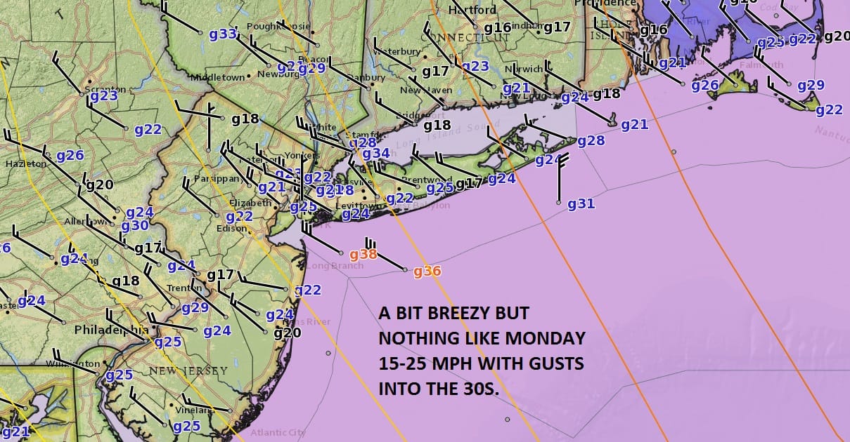
One of the signs of approaching spring is the increasing number of days with wind as the temperature contrast in the atmosphere gets sharper. We have another major storm moving away from Northern New England and high pressure to the west with cold air coming down out of Canada. The air behind this storm is not exceptionally cold and the winds while gusting into the 30s are nothing like what they were on Monday.
The satellite loop is showing that storm to the east as well as some clouds around the Great Lakes. We will see clouds mixing in today with temperatures reaching the upper 30s and lower 40s. Radars are quiet here though some snow continues in lake effect areas to the north and to the west.
SATELLITE LOOP

REGIONAL RADAR

Tonight looks clear and cold with lows in the 20s and Friday we will see sunshine with less wind and highs again in the upper 30s to some lower 40s.
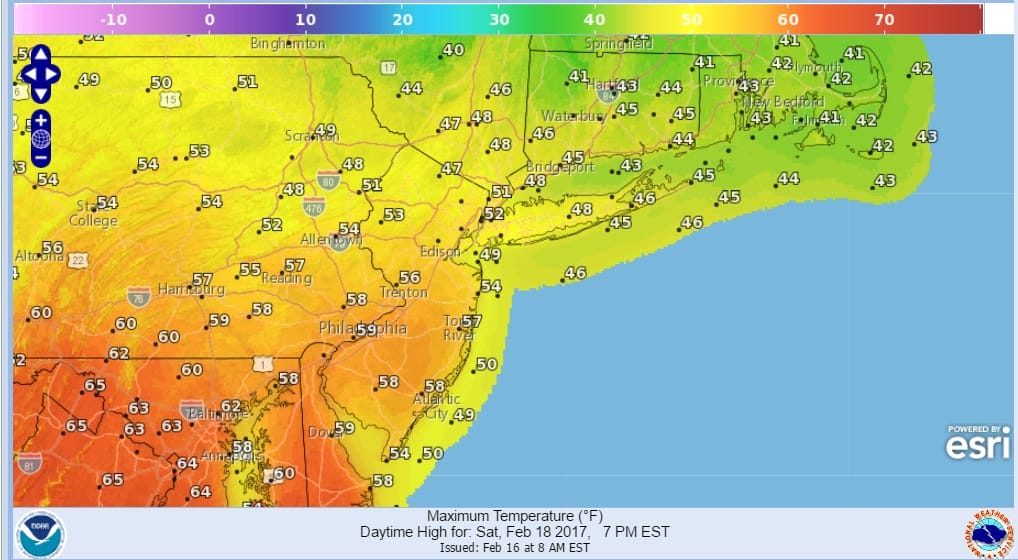
SPRINGLIKE FORECAST HIGHS SATURDAY
SPRINGLIKE FORECAST H
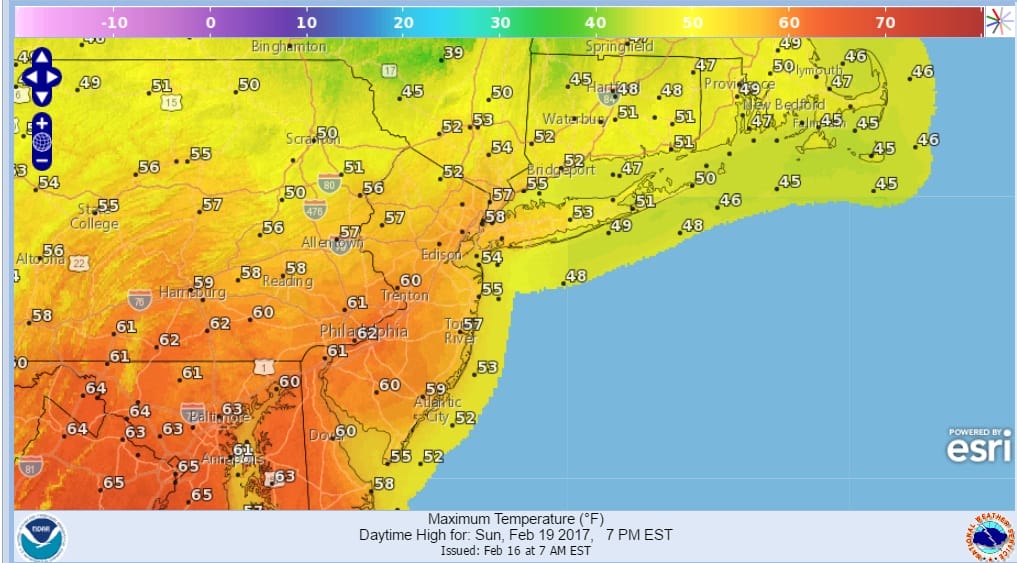
The warm up and the warmer pattern begin on Saturday and there could be some clouds coming in as temperatures start their rise. Some sun will break through the clouds as highs reach into the 50s in some areas away from the ocean and deep snow cover. Sunday looks very good with sunshine and highs reaching into the 60s in locations just inland of the coast. The nice weather continues for Monday which is the third day of the holiday weekend though temperatures won’t be as warm thanks to a northeast wind.
 GET JOE A CIGAR IF YOU LIKE

SNOW REMOVAL COMPANIES FOR YOUR WINTER NEEDS
LONG ISLAND ROCKLAND COUNTY Connecticut

![]()

ROCKLAND COUNTY TRI STATE SNOW REMOVAL JOHNSTOWN PA


FiOS1 News Weather Forecast For Long Island
FiOS1 News Weather Forecast For New Jersey
FiOS1 News Weather Forecast For Hudson Valley
NATIONAL WEATHER SERVICE SNOW FORECASTS
LATEST JOESTRADAMUS ON THE LONG RANGE
Weather App

Don’t be without Meteorologist Joe Cioffi’s weather app. It is really a meteorologist app because you get my forecasts and my analysis and not some automated computer generated forecast based on the GFS model. This is why your app forecast changes every 6 hours. It is model driven with no human input at all. It gives you an icon, a temperature and no insight whatsoever.
It is a complete weather app to suit your forecast needs. All the weather information you need is right on your phone. Android or I-phone, use it to keep track of all the latest weather information and forecasts. This weather app is also free of advertising so you don’t have to worry about security issues with your device. An accurate forecast and no worries that your device is being compromised.
Use it in conjunction with my website and my facebook and twitter and you have complete weather coverage of all the latest weather and the long range outlook. The website has been redone and upgraded. Its easy to use and everything is archived so you can see how well Joe does or doesn’t do when it comes to forecasts and outlooks.
Just click on the google play button or the apple store button on the sidebar for my app which is on My Weather Concierge. Download the app for free. Subscribe to my forecasts on an ad free environment for just 99 cents a month.
Get my forecasts in the palm of your hand for less than the cost of a cup of Joe!


