
Presidents Day Weekend Perfect
Presidents Day Weekend Perfect
The holiday weekend is upon is and there are no important changes in the outlook for Presidents Day Weekend. Some subtle changes in the temperatures are the only changes we are making. It now appears Saturday will be the milder of the two days as a weak weather front and wind shift to the north look to occur early on Sunday instead of late in the day. Otherwise temperatures will be above normal through Thursday of next week.
FORECAST LOW TEMPERATURES FRIDAY MORNING
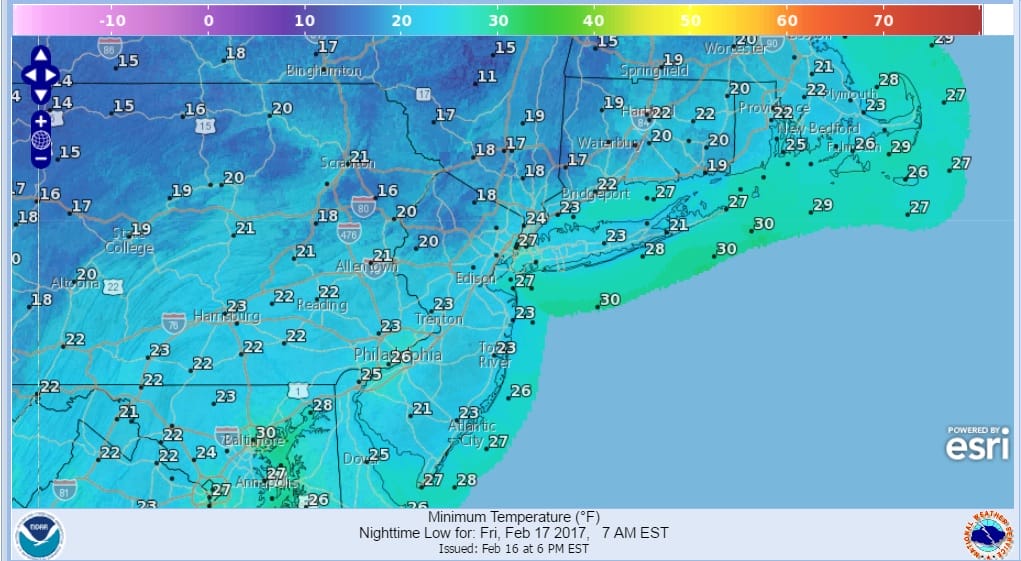
The satellite loop shows a strong storm churning through New Foundland tonight and dry cold air is coming down on gusty northwest winds this evening. Those winds will decrease later tonight as temperatures head down into the upper teens to mid 20s.
SATELLITE LOOP

REGIONAL RADAR

Friday we will see lots of sunshine with highs in the low to mid 40s in most places. Friday night temperatures wont fall too far except where there is a snow cover and clear skies. Saturday look for sunshine with some passing clouds and highs reaching the 50s everywhere. The only exception may be along the immediate coast where a sea breeze will probably develop and hold temperatures down. Sunday looks nice and sunny with highs in the low to mid 50s though it might be in the upper 50s to near 60 in Southern New Jersey and Southeastern Pennsylvania. Monday looks good too with sunshine and highs in the upper 40s to lower 50s.
Longer range it looks to stay warm through Thursday of next week but after that some weather models are trending colder. I still believe (even more strongly today) that there will be a couple of chances for snow late month and into March. We will discuss this in detail over the next few days.
 GET JOE A CIGAR IF YOU LIKE

SNOW REMOVAL COMPANIES FOR YOUR WINTER NEEDS
LONG ISLAND ROCKLAND COUNTY Connecticut

![]()

ROCKLAND COUNTY TRI STATE SNOW REMOVAL JOHNSTOWN PA


FiOS1 News Weather Forecast For Long Island
FiOS1 News Weather Forecast For New Jersey
FiOS1 News Weather Forecast For Hudson Valley
NATIONAL WEATHER SERVICE SNOW FORECASTS
LATEST JOESTRADAMUS ON THE LONG RANGE
Weather App

Don’t be without Meteorologist Joe Cioffi’s weather app. It is really a meteorologist app because you get my forecasts and my analysis and not some automated computer generated forecast based on the GFS model. This is why your app forecast changes every 6 hours. It is model driven with no human input at all. It gives you an icon, a temperature and no insight whatsoever.
It is a complete weather app to suit your forecast needs. All the weather information you need is right on your phone. Android or I-phone, use it to keep track of all the latest weather information and forecasts. This weather app is also free of advertising so you don’t have to worry about security issues with your device. An accurate forecast and no worries that your device is being compromised.
Use it in conjunction with my website and my facebook and twitter and you have complete weather coverage of all the latest weather and the long range outlook. The website has been redone and upgraded. Its easy to use and everything is archived so you can see how well Joe does or doesn’t do when it comes to forecasts and outlooks.
Just click on the google play button or the apple store button on the sidebar for my app which is on My Weather Concierge. Download the app for free. Subscribe to my forecasts on an ad free environment for just 99 cents a month.
Get my forecasts in the palm of your hand for less than the cost of a cup of Joe!


