Spring Weather Weekend

We have a warm front moving through tonight across the area and this marks the leading edge of milder air that will be with us for the weekend. The satellite loop shows low pressure moving across the Great Lakes and heading into Northern New England. Other than a shower or snow shower tonight we should be dry with temperatures holding steady or even rising through the 30s to near 40 by morning.
Spring Weather Weekend Satellite Loop

Spring Weather Weekend Radar Loop

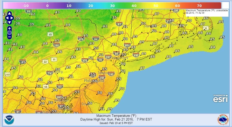
For Saturday it will be an early preview of spring with any early clouds giving way quickly to sunshine with highs in the 50s and some areas from Central New Jersey to Southeastern Pennsylvania approaching 60! Sunday looks dry during the day with some early sunshine giving way to arriving clouds with highs in the upper 40s to mid 50s.
Spring Weather Weekend Saturday High Temperatures

Spring Weather Weekend Sunday High Temperatures
A cold front moves through. Sunday night into Monday we could see some precipitation, either rain or a light mix. The NAM model has been more aggressive with this but it seems to stand alone on the idea of .50 to .75 inches of precip. It also shows a colder atmosphere. All the other weather models seem subdued with this system and we will cautiously lean in the subdued direction unless proven otherwise.
Longer range we have a complex storm system for late Tuesday and lasting into Thursday morning as indicated by the European model. There are still a lot of specific forecast issues to work through with this system.
EUROPEAN MODEL ANALSYIS FROM 02/19/2016 3PM
NATIONAL WEATHER SERVICE SNOW FORECASTS
LATEST JOESTRADAMUS ON THE LONG RANGE
Weather App

Winter is INSANE! With yet another threat for a coastal storm don’t be without Meteorologist Joe Cioffi’s weather app. It is really a meteorologist app because you get my forecasts and my analysis and not some automated computer generated forecast based on the GFS model. This is why your app forecast changes every 6 hours. It is model driven with no human input at all. It gives you an icon, a temperature and no insight whatsoever.
It is a complete weather app to suit your forecast needs. All the weather information you need is right on your phone. Android or I-phone, use it to keep track of all the latest weather information and forecasts. This weather app is also free of advertising so you don’t have to worry about security issues with your device. An accurate forecast and no worries that your device is being compromised.
Use it in conjunction with my website and my facebook and twitter and you have complete weather coverage of all the latest weather and the long range outlook. The website has been redone and upgraded. Its easy to use and everything is archived so you can see how well Joe does or doesn’t do when it comes to forecasts and outlooks.
Just click on the google play button or the apple store button on the sidebar for my app which is on My Weather Concierge. Download the app for free. Subscribe to my forecasts on an ad free environment for just 99 cents a month.
Get my forecasts in the palm of your hand for less than the cost of a cup of Joe!
![]()