Euro Models Midweek Storm Update

Euro Models Midweek Storm Update for today brings today’s version of forecast events. The sequence of how this plays out is similar on the GFS model with timing differences. Euro models the last few days showed volatility from run to run but off all the weather models it was at least more consistent. Two lows appear to be at play with oddly was something models showed days ago and we seem to be coming back to this idea. The problem in the evolution of this entire event has been the fact that there have been numerous waves of energy in the northern and southern jet stream keep changing in magnitude and speed. This has caused each run to react differently and even change the look entirely. Now we seem to be heading back to something that makes some sense. However don’t be surprised if this changes yet again.
EURO MODELS FRIDAY AFTERNOON FORECAST FOR WEDNESDAY MORNING

This look on the Euro models would not favor snow for the coastal areas mainly because the cold high to the north will be moving out to the east. There is no blocking to hold the high back. A lead low runs out ahead with an area of precipitation. Euro models temperature profiles arguing for some icing Tuesday night in areas like Northwest New Jersey and Northeastern Pennsylvania northeastward across the Hudson Valley of New York and interior Connecticut. This would then go to rain by Wednesday morning.
EURO MODELS FORECAST THURSDAY MORNING
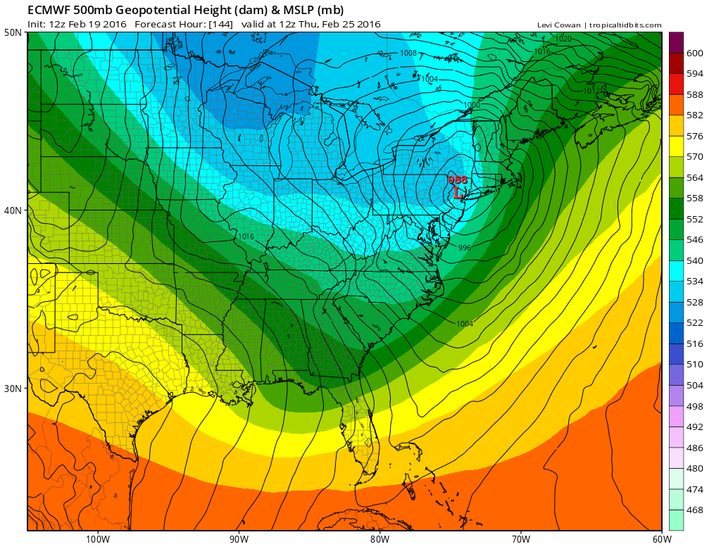
Notice that there is a second low present on the Euro models which becomes the main storm Wednesday and Wednesday night. It takes a deepening low right up the coast with the low center right over New York City by Thursday morning. This would mean a windswept soaking rain here for Wednesday and Wednesday night. Snow would be well inland from Interstate 81 westward according to this model run.

It is like watching a series of gears in action. The first lead system just lifts up on its own while the second one in the north gets ready to line up and phase with the system in the south. The result is the deep low you see on the surface maps above. Trying to keep up with these model adjustments has been almost nightmarish from a forecast standpoint. This is why I’m been hesitant in making any sort of commitment in terms of the actual forecast. It seems clear that cold air will be lacking at the coast no matter what happens. What remains a question is whether this phased look is going to be the final model adjustment. Or are we going to see other adjustments overnight and Saturday depending on the actual speed and strength of all the energy? As logical as this model run seems, something tells me that more adjustments may be coming.
One thing that should be noted. Given that the set up of an ocean flow beginning late Monday and lasting into Wednesday, and given that Monday night is a full moon, coastal flooding along the New Jersey and Long Island shorelines will be a big risk. Given that moderate coastal flooding has been occuring in cases where it normally would be minor, it seems to me that this could at the very least evolve into a moderate coastal flooding episode at the very least.
LATEST OVERNIGHT GFS/CANADIAN/NAM MODEL ANALYSIS
NATIONAL WEATHER SERVICE SNOW FORECASTS
LATEST JOESTRADAMUS ON THE LONG RANGE
Weather App

Winter is INSANE! With yet another threat for a coastal storm don’t be without Meteorologist Joe Cioffi’s weather app. It is really a meteorologist app because you get my forecasts and my analysis and not some automated computer generated forecast based on the GFS model. This is why your app forecast changes every 6 hours. It is model driven with no human input at all. It gives you an icon, a temperature and no insight whatsoever.
It is a complete weather app to suit your forecast needs. All the weather information you need is right on your phone. Android or I-phone, use it to keep track of all the latest weather information and forecasts. This weather app is also free of advertising so you don’t have to worry about security issues with your device. An accurate forecast and no worries that your device is being compromised.
Use it in conjunction with my website and my facebook and twitter and you have complete weather coverage of all the latest weather and the long range outlook. The website has been redone and upgraded. Its easy to use and everything is archived so you can see how well Joe does or doesn’t do when it comes to forecasts and outlooks.
Just click on the google play button or the apple store button on the sidebar for my app which is on My Weather Concierge. Download the app for free. Subscribe to my forecasts on an ad free environment for just 99 cents a month.
Get my forecasts in the palm of your hand for less than the cost of a cup of Joe!
![]()