
Spring Moving To NYC
![]()
Spring Moving To NYC is the theme for the next several days. The last of the colder air will move out tonight under mainly clear skies. Temperatures inland should drop into the 20s while warmer urban locations will bottom in the lower 30s with not much wind. Satellite loops show clouds to the west that might move through at some point tonight but other than that there isn’t much to worry about.
Spring Moving To NYC Satellite Loops


Radars are absolutely quite this evening both regionally and locally. I don’t expect to see much if any action radar wise for our area for the next several days.
Spring Moving To NYC Local Radar Loops


The temperature forecasts are pretty straight forward for the next several days. It should be no worse than partly sunny each day. Temperatures will reach the 50s Monday, 60s Tuesday, and 70s Wednesday.
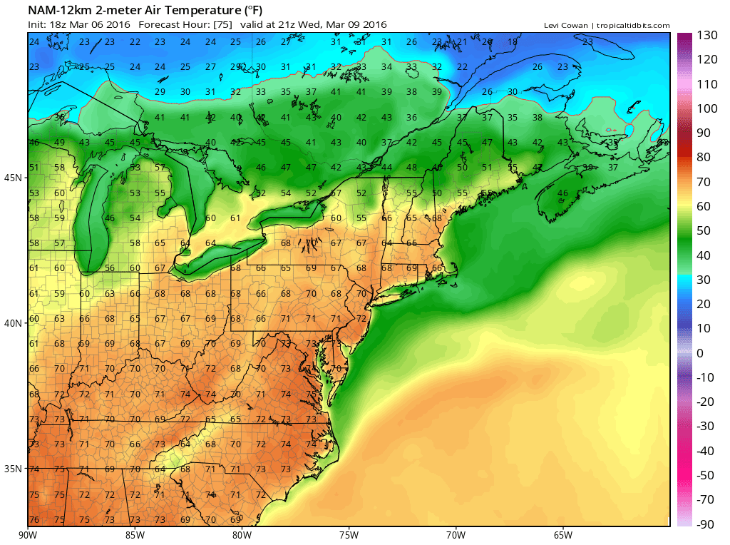
Coastal areas will have afternoon sea breezes developing which is typical of the spring. Ocean water temperatures are at their seasonal lows in the upper 30s and lower 40s which always sets up for a sea breeze as the land warms up faster. The upper air pattern sets up perfectly for a warm first half of this coming week with a strong ridge in the east and troughing mostly in the west.
Spring Moving To NYC Upper Air Flow Midweek

The big question mark is for Thursday and the timing of a back door cold front. The GFS model wants to rush it through here early Thursday which would mean for clouds, some rain or drizzle and temperatures in the 40s. The European doesn’t bring the back door through here until late in the day Thursday. This would mean a second day of 70 degree readings before we go to clouds, rain and drizzle late Thursday or Thursday night with northern areas like the Hudson Valley and Long Island going first and Southern New Jersey and Southern Pennsylvania going after the day is done. We will lean toward the European idea and squeeze in one more 70 degree plus day before it turns raw and chilly. No big storms are on the horizon for this week.
FiOS1 News Weather Forecast For Long Island
FiOS1 News Weather Forecast For New Jersey
FiOS1 News Weather Forecast For Hudson Valley
NATIONAL WEATHER SERVICE SNOW FORECASTS
LATEST JOESTRADAMUS ON THE LONG RANGE
Weather App

Don’t be without Meteorologist Joe Cioffi’s weather app. It is really a meteorologist app because you get my forecasts and my analysis and not some automated computer generated forecast based on the GFS model. This is why your app forecast changes every 6 hours. It is model driven with no human input at all. It gives you an icon, a temperature and no insight whatsoever.
It is a complete weather app to suit your forecast needs. All the weather information you need is right on your phone. Android or I-phone, use it to keep track of all the latest weather information and forecasts. This weather app is also free of advertising so you don’t have to worry about security issues with your device. An accurate forecast and no worries that your device is being compromised.
Use it in conjunction with my website and my facebook and twitter and you have complete weather coverage of all the latest weather and the long range outlook. The website has been redone and upgraded. Its easy to use and everything is archived so you can see how well Joe does or doesn’t do when it comes to forecasts and outlooks.
Just click on the google play button or the apple store button on the sidebar for my app which is on My Weather Concierge. Download the app for free. Subscribe to my forecasts on an ad free environment for just 99 cents a month.
Get my forecasts in the palm of your hand for less than the cost of a cup of Joe!
![]()
![]()
<


