Spring Day Clouds Sun Thunderstorms Tonight Severe Weather Risk
A warm front has passed through this morning with few issues other than clouds. We are seeing some sunshine and a slightly more humid air mass building in. A storm has come out of the Plains and is now in the Western Great Lakes and well to our west. We see on the satellite picture this morning there isn’t much in the way of cloud cover to the south of us. To the west clouds are still not that close but an unstable air mass will allow for some showers and thunderstorms to develop in Eastern Pennsylvania this afternoon. For most we will be no worse than a mix of sun and clouds with a southwest breeze and temperatures reaching the mid 70s to lower 80s.
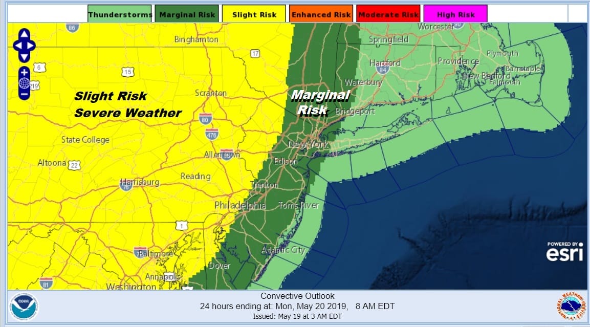
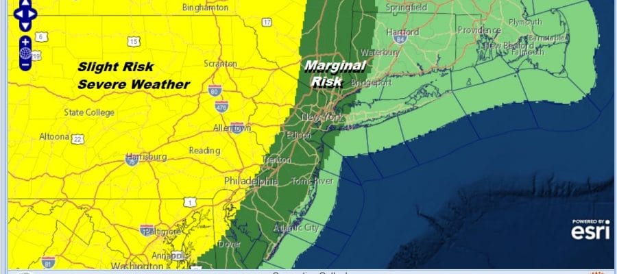
The Storm Prediction Center has been busy with severe weather in the Plains for days but some attention shifts to the Eastern US today with a slight risk of severe weather being indicated for Pennsylvania in Northwest New Jersey. The slight risk also extends northward into the Catskills. Marginal Risk for the Hudson Valley Western Connecticut to NYC south to along the New Jersey shore & Western Long Island.
SATELLITE

REGIONAL RADAR

Some thunderstorms are on the radar this morning across Upstate NY north and west of I-90 moving east southeast into Central New England. For now areas to the west remain quiet and should be until this afternoon when some thunderstorms will start to develop.
LOCAL RADAR NEW YORK CITY

LOCAL RADAR PHILADELPHIA


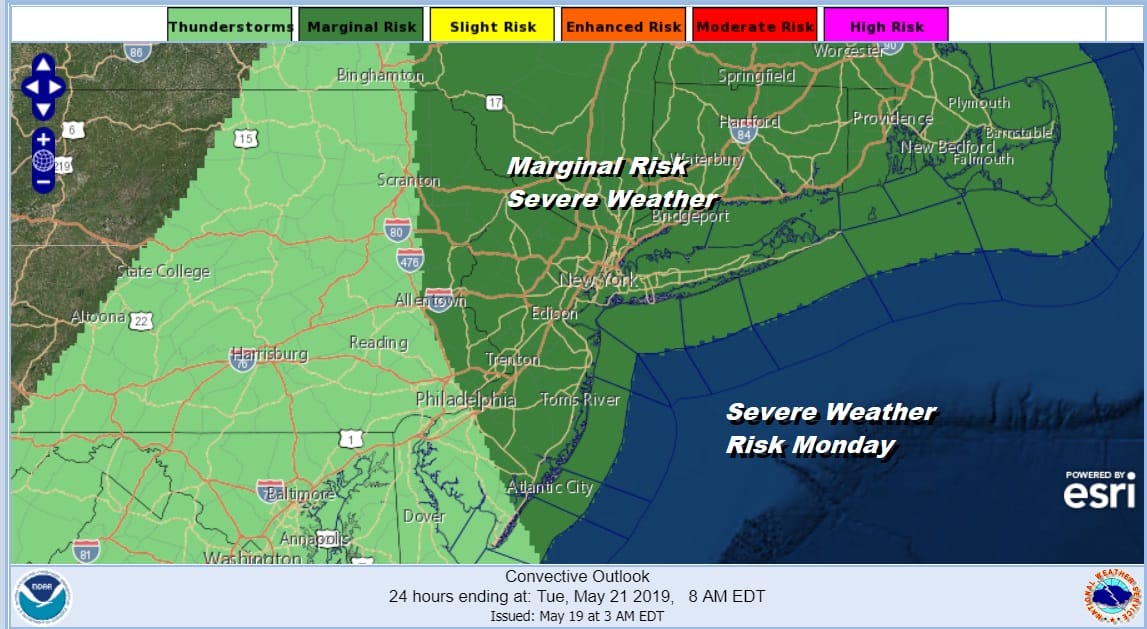
Today is the final round of the PGA Golf Championship at Bethpage NY on Long Island. There will be no rain issues into this evening with the shower and thunderstorm risk greater for the overnight into Monday morning. Tonight we will see some scattered showers and thunderstorms. A cold front will be approaching leading us into what should be a warm Monday. A cold front doesn’t move through until late in the day when there could be some developing late day thunderstorms. The Storm Prediction Center has the entire area at a marginal risk for severe weather on Monday.
What is interesting about Monday is that the front doesn’t show much strength until it starts to cross the area. This would put thunderstorms in the development phase which is when they can be there most potent and their most expressive (lots of lightning and thunder). The Nam model shows the beginnings of this for later Monday afternoon but until then we will see sunshine and temperatures reaching the 80s in many locations including near the coast. This will be the warmest day of the spring season so far.

While this front passes through the east, another major storm will be running northward through the Western Plains with a perhaps explosive round of severe weather on Monday in the Southern Plains. The storm track to the west again means we get two nice days of weather with sunshine Tuesday and Wednesday along with cooler temperatures. Highs will be reaching into the 70s both days with no real weather issues until Thursday as the next warm front cold front combination moves through. Next weekend is the Memorial Day holiday weekend. Right now it looks like we might get 2 out of 3 days with some sunshine with one day of shower risk and that would be Saturday. What is important to focus on is that the pattern DOES NOT favor a long duration stretch of onshore winds and low pressure to the south. If we do get showers Saturday they will be frontal in nature and short lived. We will address the Memorial Day holiday weekend in a separate post later today.
MANY THANKS TO TROPICAL TIDBITS FOR THE USE OF MAPS
Please note that with regards to any tropical storms or hurricanes, should a storm be threatening, please consult your local National Weather Service office or your local government officials about what action you should be taking to protect life and property.


