
Soupy Weather Continues For A While Longer Some Improvement Monday
Much of the area did not get out of the soup today. The last of the showers have shifted up into New England where some areas are getting a few thunderstorms. We are just waiting for a front to move through tonight and shift the winds to the west. That will at least get rid of the low clouds drizzle and fog that we are still dealing with and we will be left with leftover clouds. Temperatures went nowhere today as temperatures held mostly in the 40s to mid 50s. We will likely settle in the 40s all night.
SATELLITE

REGIONAL RADAR

Radars are still picking up a few showers and a thunderstorm or two but these should disappear before to long. We will probably see some scattered showers around on Monday. In Maine and Northeastern New Hampshire colder air will come into the mix on Monday and those areas could see some accumulating snow especially in Maine where half a foot or more could fall in the northern parts of that state.
LOCAL RADAR NEW YORK CITY

LOCAL RADAR PHILADELPHIA


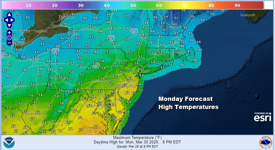
Back home we will see variable clouds with the sun trying to poke through from time to time. However an upper trough will likely keep clouds around and there could be a few scattered showers in the mix, mostly inland. Highs Monday will have a wide range. Areas in Southern New Jersey and points south and west should reach the 60s while areas north of NYC will likely remain in the 50s.
Early to mid spring is known for the rather blocky pattern that sets up across the North Atlantic and this spring is no different. This pattern a month ago would have spelled trouble with cold and snow but as we know this pattern was completely absent during the winter months. Seeing it now means chilly conditions with cloud issues much of the time. This will be the story for the week ahead. Temperatures Tuesday will be in the upper 40s to lower 50s for highs.
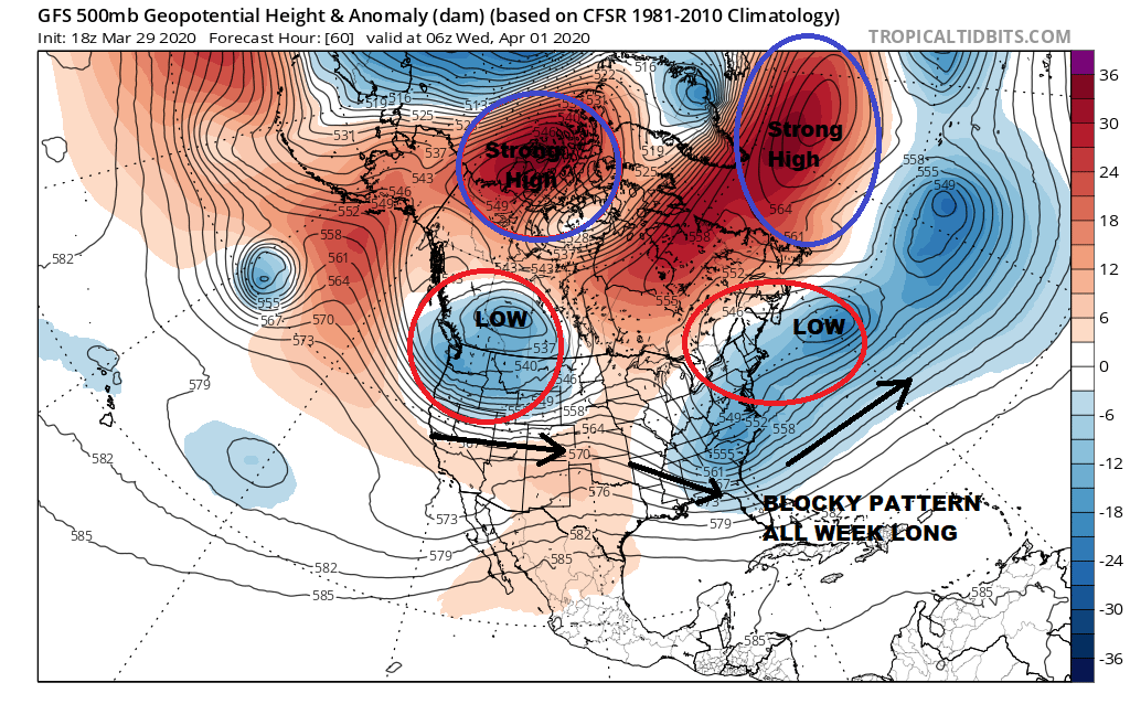
The next low coming out of the Southern Plains will pass well to the south on Wednesday but an onshore flow will likely keep us in some cloud cover along with chilly temperatures again in the upper 40s and lower 50s. We might catch a break at the end of the week as the blocking signature weakens somewhat and perhaps we can finish the week with some sunshine for Thursday and Friday along with slightly warmer temperatures though they will be hovering close to or a little below average for this time of year.
BE SURE TO DOWNLOAD THE FREE METEOROLOGIST JOE CIOFFI WEATHER APP &
ANGRY BEN’S FREE WEATHER APP “THE ANGRY WEATHERMAN!
MANY THANKS TO TROPICAL TIDBITS FOR THE USE OF MAPS
Please note that with regards to any severe weather, tropical storms, or hurricanes, should a storm be threatening, please consult your local National Weather Service office or your local government officials about what action you should be taking to protect life and property.


