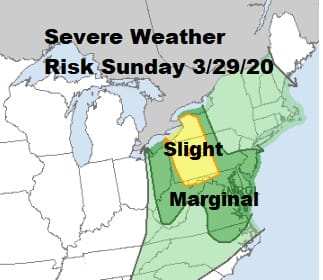
Severe Weather Risk New Jersey Pennsylvania Soupy Sunday Ahead

Some of you messaged me this morning after hearing thunder. Yes the first thunderstorms of the spring season are here and as we know spring is one of the more turbulent times of the year since we are fighting battles between the remnants of winter with cold air to the north and the warming that is occurring with the lengthening daylight. It is all part of the process folks and today the process will involve a warm front to our south this morning that will make only limited progress northward. This sets us up for severe weather risk today as the map from the Storm Prediction Center above indicates.

This is a typical spring time battle in the northeast with a low in the Great Lakes and a pinched off warm front that meanders around the mountains to the coast pinning cool marine air from New England south into Virginia. Eventually the warmer air wins out and pushes northward but how far north it gets today remains to be seen.
SATELLITE

REGIONAL RADAR

In the meantime we remain socked in with clouds as the satellite picture shows us. The regional and local radars are still picking up on showers and even a thunderstorm or two is in the mix though any severe weather issues will come later today.
LOCAL RADAR NEW YORK CITY

LOCAL RADAR PHILADELPHIA


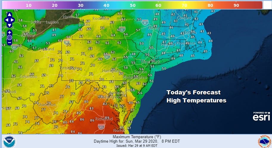
The severe weather risk zone sets up for Central and Southern New Jersey west into Pennsylvania and south into Northeast North Carolina. This is where we will see warmer air take hold this afternoon shooting temperatures higher. Note the wide range from 80s in Virginia to 40s in Southern New England. Clearly we have quite a contrast here and that sets up for scattered thunderstorms later today.
Weather conditions will slowly improve tonight as these fronts pass through but the low in the Great Lakes will be slowing down thanks to blocking in the North Atlantic. This means that weather conditions will only marginally improve for the first half of this week.

The low itself will still be spinning around offshore with an upper trough moving by on Monday. Look for variable clouds with some breaks of sun and the risk for a passing shower. Highs will have a wide range depending on cloud cover so inland areas and areas north of NYC will be in the cooler 50s while areas to the south say from Philadelphia and Route 195 in NJ south will be in the 60s. Tuesday and Wednesday will be much cooler everywhere with most highs in the upper 40s and lower 50s thanks to clouds and an onshore flow. Weather models continue to show the strong blocking forcing low pressure from the Southern Plains to pass off the Carolinas keeping rain well to our south. Better weather comes Thursday and Friday before we see another chance for showers at some point next weekend.
BE SURE TO DOWNLOAD THE FREE METEOROLOGIST JOE CIOFFI WEATHER APP &
ANGRY BEN’S FREE WEATHER APP “THE ANGRY WEATHERMAN!
MANY THANKS TO TROPICAL TIDBITS FOR THE USE OF MAPS
Please note that with regards to any severe weather, tropical storms, or hurricanes, should a storm be threatening, please consult your local National Weather Service office or your local government officials about what action you should be taking to protect life and property.


