Some Showers Thunderstorm Warm Front Approaches Warm Humid Sunday
Much of today was delightful with sunshine and some patch clouds. A weak warm front is coming through tonight and that will bring in clouds this evening. We are seeing some showers & thunderstorms developing in Southwestern Pennsylvania at the moment moving to the east northeast. We will see the chance for showers or a thunderstorm rolling through parts of the area probably between 8pm and 11pm tonight. They shouldn’t amount to too much as they roll on through but there could be a few heavier downpours in the mix.
SATELLITE

REGIONAL RADAR

The passage of the warm front will bring in a warmer more humid air mass that will be with us for Sunday. Local radar views below will start to pick up on these showers and downpours soon. Some rain is showing up already in parts of NW New Jersey but it is mostly aloft.
LOCAL RADAR NEW YORK CITY

LOCAL RADAR PHILADELPHIA


There are no changes for Sunday which will be a warm humid day with sunshine & clouds with highs in the 80s though it will be cooler along the immediate shore. A cold front will approach Sunday evening and there could be scattered showers & thunderstorms with its passage. However much of the time Sunday it will be rain free.
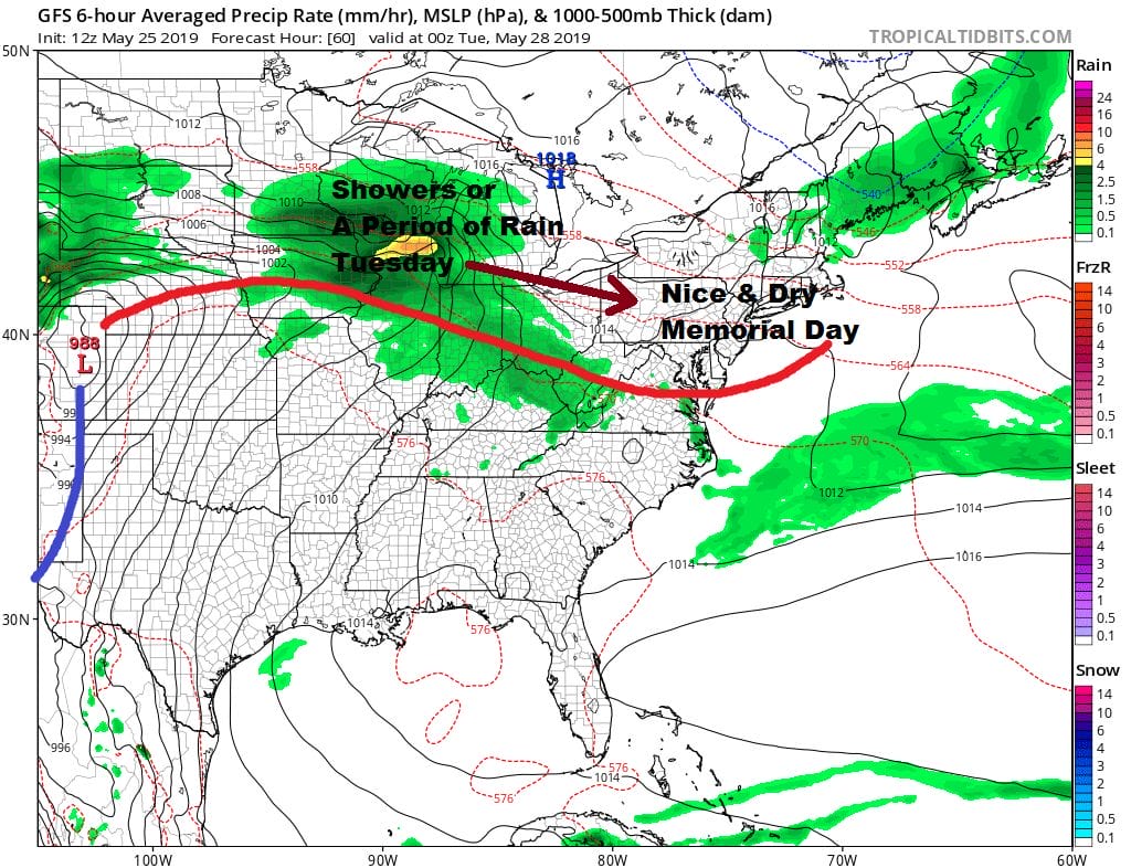
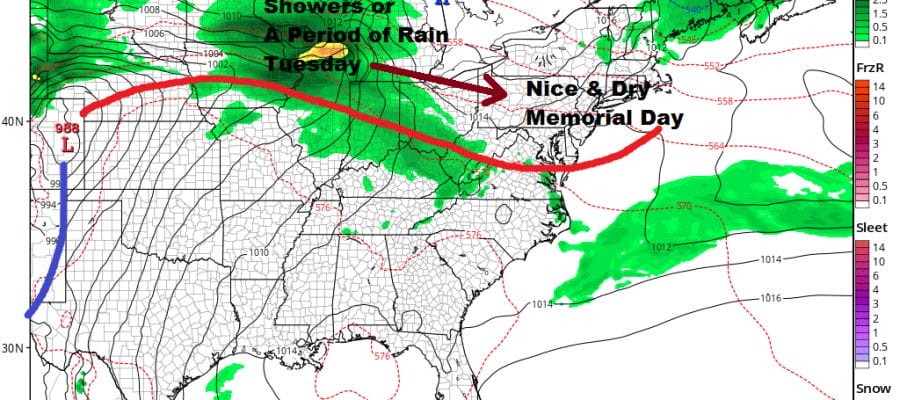
There are also no changes to Monday Memorial Day which will be nice day. We are expecting plenty of sunshine and nothing more than a few passing clouds. Highs will be in the mid 70s to lower 80s. No rain is forecast for Monday or Monday night. Sunday’s cold front stalls to the south and another major storm develops in the Plains on Monday. This will bring the warm front slowly northward Tuesday with clouds and showers with highs just into the 70s well inland and mostly 60s elsewhere.

Wednesday and Thursday we transition to a very warm and humid air mass with a southwest flow. Highs Wednesday should reach the 80s and Thursday we could see readings approaching 90 or even higher in some places. There will be thunderstorm risks both Wednesday and Thursday in this air mass. Another cold front passes Thursday night followed by a dry cooler air mass for next Friday and Saturday.
MANY THANKS TO TROPICAL TIDBITS FOR THE USE OF MAPS
Please note that with regards to any tropical storms or hurricanes, should a storm be threatening, please consult your local National Weather Service office or your local government officials about what action you should be taking to protect life and property.


