
Solar Eclipse Cloud Chances Based On Climate
Solar Eclipse Cloud Chances Based On Climate
The saying on financial product commercials is that past performance can not guarantee future results. But it is the only thing we have to look at and since history does tend to rhyme, lets look at where the best chances for cloud free skies for Monday August 21st which is the day of the solar eclipse.
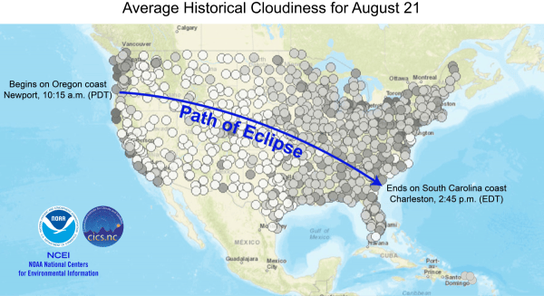
What the map above shows is that the best places are in the west and just inland of the west coast to the Plains. In the East it isn’t so good because clouds like to develop even on the driest of days and a cloud free day this time of year from start to finish is a rare event indeed. Considering the narrow path of totality, if you are heading anywhere along that path be sure to pick well.
SOLAR ECLIPSE GFS MODEL FORECAST FOR MONDAY AUGUST 21, 2017 2PM

Judging from the overnight runs of the GFS & other models the solar eclipse cloud history match may play out rather well. The GFS would suggest the best chances for cloud free conditions would be west of the Mississippi River to the West Coast except for the Northwest US. East of the Mississippi since it looks like we would be in a warm and humid air mass there will be clouds and the chance for thunderstorms. We will of course discuss this further in the coming days.
SATELLITE LOOP

This morning on the satellite loop we do seem to have some patchy clouds but this is not preventing the sun from coming through. It should be a nice day with temperatures in the low to mid 80s and humidity levels will be reasonable. Radars are nice and quiet and will remains so. The clouds east of the Bahamas is Tropical Depression 8 which is forecast to become Tropical Storm Gert later today. However it is no threat to the United States as it will move northward and then turn northeastward in the coming days.
REGIONAL RADAR

LOCAL RADAR NEW YORK CITY

LOCAL RADAR PHILADELPHIA


Tonight looks nice and clear with lows in the 60s. Look for nice weather through Wednesday this week with nothing more than some occasional clouds from day to day, no showers, and temperatures generally between 80 and 85 degrees. It might be a shade higher than that on Wednesday. Then the next warm from cold front approaches on Thursday with the chance for showers and thunderstorms later Thursday and Friday.
 GET JOE A CIGAR IF YOU LIKE

FiOS1 News Weather Forecast For Long Island
FiOS1 News Weather Forecast For New Jersey
FiOS1 News Weather Forecast For Hudson Valley


