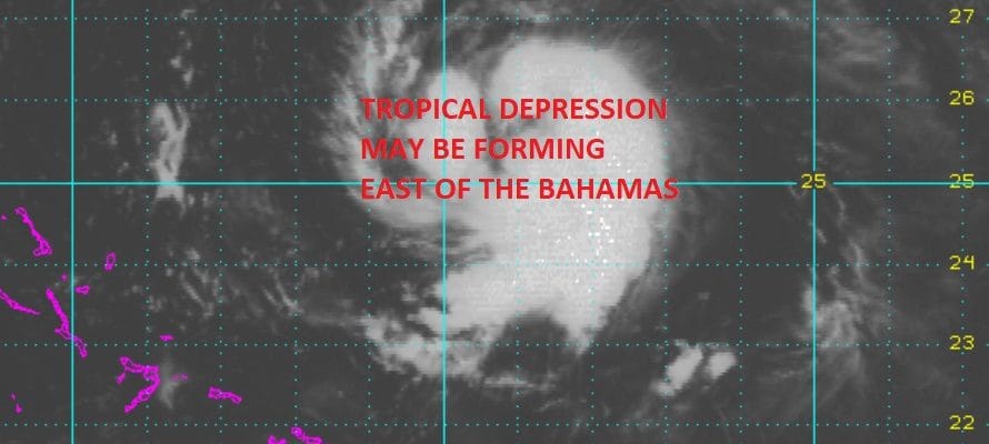
TROPICAL DEPRESSION MAY BE FORMING EAST OF THE BAHAMAS
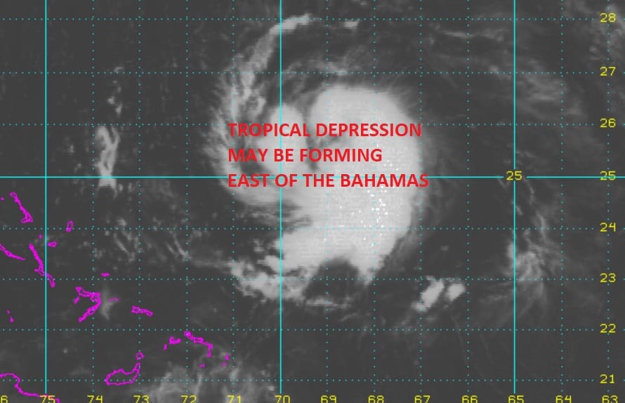
TROPICAL DEPRESSION MAY BE FORMING EAST OF BAHAMAS
Latest satellite pictures show that disturbed weather east of the Bahamas continues to become better organized and there is evidence now of a low level circulation developing which means that a tropical depression may form here overnight or on Sunday. You can see on the loop clouds definitely circulating around on the north side as convection continues to increase. The area is moving norrthwestward and will pass east of the Bahamas with no threat there even if it does develop.

This tropical wave has been with us for well over a week now and this is the same system that some global models developed into a hurricane 10 days ago. You can clearly see that the outcome was much different than modeled. This is why we can’t put too much emphasis on what the models do with tropical storms in the long range.

On the wider satellite views a strong tropical wave has emerged off the African coast and is now southwest of the Cabo Verde Islands and moving westward. Issues with dry air remain as shown on the water vapor loop below. There is also an upper air storm in the Central Atlantic but it appears that least the winds aloft may be favorable. This storm may be too far north to produce hostile wind conditions aloft to the south where the tropical wave lies.

This may be another test of the GFS in how it handles tropical systems as it develops this into a tropical storm by late Wednesday. We shall see.
If the system off the East Coast does develop it will turn northward and then northeastward. It is no threat to land.
MANY THANKS TO TROPICAL TIDBITS FOR THE WONDERFUL USE OF THE MAPS
NEW LIVESTREAM APP FOR IPHONES
Weather App

Don’t be without Meteorologist Joe Cioffi’s weather app. It is really a meteorologist app because you get my forecasts and my analysis and not some automated computer generated forecast based on the GFS model. This is why your app forecast changes every 6 hours. It is model driven with no human input at all. It gives you an icon, a temperature and no insight whatsoever.
It is a complete weather app to suit your forecast needs. All the weather information you need is right on your phone. Android or I-phone, use it to keep track of all the latest weather information and forecasts. This weather app is also free of advertising so you don’t have to worry about security issues with your device. An accurate forecast and no worries that your device is being compromised.
Use it in conjunction with my website and my facebook and twitter and you have complete weather coverage of all the latest weather and the long range outlook. The website has been redone and upgraded. Its easy to use and everything is archived so you can see how well Joe does or doesn’t do when it comes to forecasts and outlooks.
Just click on the google play button or the apple store button on the sidebar for my app which is on My Weather Concierge. Download the app for free. Subscribe to my forecasts on an ad free environment for just 99 cents a month.
Get my forecasts in the palm of your hand for less than the cost of a cup of Joe!