
DRY START GIVES WAY TO RAIN TONIGHT TUESDAY
COLD FRONT WEDNESDAY WARM HUMID SEVERE WEATHER THREAT
LOW OFF SOUTHEAST COAST CONTINUES MOVING WEST
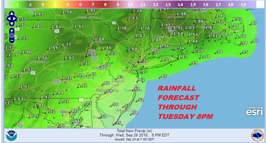
Dry air from upstate New York continues to drip southward this morning but it is having limited success. We still have a lot of clouds around this morning and as the day wears on those clouds will start moving northward and increasing. Temperatures today will be in the 60s. Last Friday’s cold front that moved through will become Tuesday’s warm front. It is going to interact with a very strong high over the Canadian Maritime Provinces to produce an increasing ocean wind and a soaking rain tonight into Tuesday.
EASTERN SATELLITE

REGIONAL RADAR

The rain that was over South Jersey and extreme Southeastern Pennsylvania for much of yesterday and last night has diminished somewhat this morning however look for radars to start revving up as the day wears on across these areas and then gradually the rain will start moving northward this evening and tonight.
LOCAL RADAR NEW YORK CITY

LOCAL RADAR PHILADELPHIA


Rain tonight should last into Tuesday morning and then become more showery in nature for the rest of Tuesday until a warm front passes through. Temperatures will be in the 60s and then hold in the 60s to near 70 Tuesday night. Tropical air sets the table for the potential for severe weather on Wednesday.
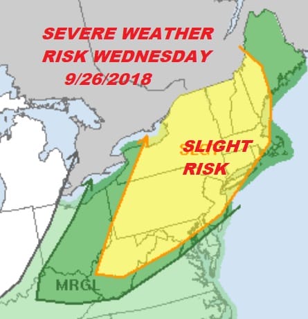
It isn’t often when you see the Storm Prediction Center put up a risk 4 days in advance but we saw this yesterday. This means pay attention on Wednesday. We are going to have lots of tropical air around, dew points into the 70s and a strong front with strengthening winds aloft. This makes things ripe for thunderstorms later Wednesday into Wednesday evening. Wednesday’s temperatures will be into the 80s in many areas. It will be the one steamy day this week. We should dry out Thursday with clouds and some sunshine. Highs will be just into the 70s. A weak wave on the front will go by Thursday night into Friday morning with not much with it. Other than a passing shower Thursday night into Friday we should be dry into the weekend.

Low pressure continues to edge closer to the Southeast Coast. We have noticed an increase int shower and thunderstorm activity this morning closer to the circulation center. The thundertorm activity is still somewhat limited but we do see a more favorable upper air wind scenario today into Tuesday. Eventually this system gets absorbed by the frontal system that is approaching but we will keep an eye on this today as it continues to move to the west. Weather models do not show this system developing much as the circulation remains broad as it heads closer to the coast.
PATREON MEMBERS LOOK FOR A LIVE STREAM THIS MORNING AT 9AM EASTERN TIME
SUBSCRIBE TO PATREON FOR A WEATHER EXPERIENCE FREE OF ADS, EXCLUSIVE VIDEOS FOR MEMBERS ONLY AND MUCH MORE…STARTS AT $2 A MONTH..MESSAGE ME AT ANY TIME

MANY THANKS TO TROPICAL TIDBITS FOR THE USE OF MAPS
Please note that with regards to any tropical storms or hurricanes, should a storm be threatening, please consult your local National Weather Service office or your local government officials about what action you should be taking to protect life and property.
LATEST JOESTRADAMUS ON THE LONG RANGE

