A CLOUDY DREARY SUNDAY RAIN LINGERS SOUTH
ANOTHER CLOUDY DAY MONDAY
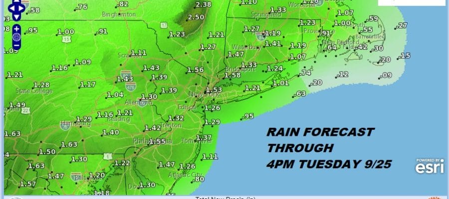
MORE RAIN MONDAY NIGHT TUESDAY

It turned out to be a rainy dreary day across much of the region. Where it rained in Central and South Jersey there was a small pocket of 1 inch plus rainfall while most of the area south of 195 got a half inch to an inch of water. Radar shows there is still some rain to work through this evening. Everyone else sat in gloomy cloudy skies as dry air from New England never quite made it far enough south to at least create some bright spots. Overnight the rain and the cloud line should shift southward somewhat and where it at least partially clears to the north in the Hudson Valley and interior Connecticut for example some lows will be in the 40s. 50s should do it everywhere else.
EASTERN SATELLITE

REGIONAL RADAR

The radars have thinned out a bit this evening and we should see the rain diminish and end during this evening where it is still hanging stubborn to the south. Clouds however will probably remain all night.
LOCAL RADAR NEW YORK CITY

LOCAL RADAR PHILADELPHIA


Monday clouds will start increasing from south to north and rain will come back into South Jersey and Southeastern Pennsylvania Monday morning and then reach NYC and points north Monday evening. Then you can expect a soaking rain Monday night into Tuesday morning before the rains become more showery in nature Tuesday afternoon. The warm front should pass Tuesday evening. Highs will be in the 60s and then temperatures hold there Tuesday night. Rainfalls of 1 to 2 inches will be quite common.

There is no important change to the outlook for Wednesday and beyond. Wednesday will be the one warm steamy day with the chance for showers and thunderstorms later in the day. Highs will be in the 70s to near 80. The front passes and while Thursday looks dry, once again the stalling front nearby could bring a round of showers again Thursday night into Friday.
We have Tropical Storm Kirk in the Eastern Atlantic, Sub Tropical Storm Leslie in the Central Atlantic, and low pressure off the Southeast US coast. Here is the latest on those systems.
LIVE STREAM TONIGHT ON YOUTUBE AT 8PM EASTERN TIME
![]()
SUBSCRIBE TO PATREON FOR A WEATHER EXPERIENCE FREE OF ADS, EXCLUSIVE VIDEOS FOR MEMBERS ONLY AND MUCH MORE…STARTS AT $2 A MONTH..MESSAGE ME AT ANY TIME

MANY THANKS TO TROPICAL TIDBITS FOR THE USE OF MAPS
Please note that with regards to any tropical storms or hurricanes, should a storm be threatening, please consult your local National Weather Service office or your local government officials about what action you should be taking to protect life and property.
LATEST JOESTRADAMUS ON THE LONG RANGE

