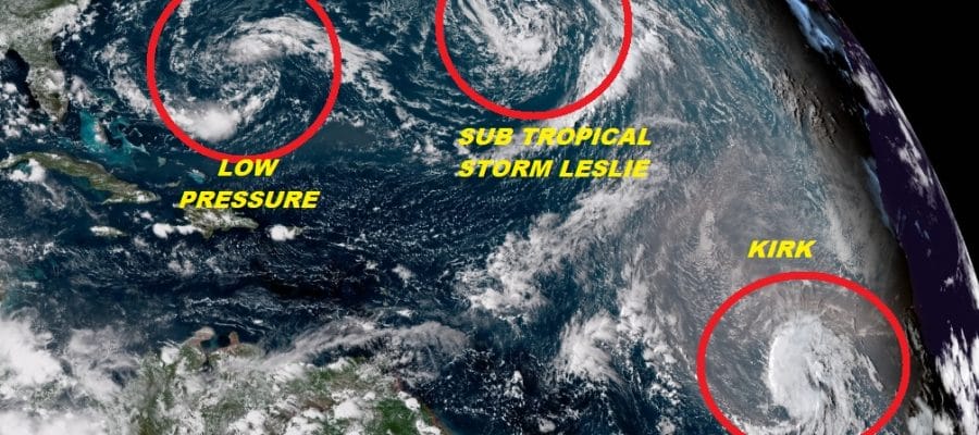
SUBTROPICAL STORM LESLIE FORMS IN THE CENTRAL ATLANTIC
TROPICAL STORM KIRK MARCHING WESTWARD
LOW PRESSURE HANGS OFF SOUTHEAST US COAST
…SUBTROPICAL STORM LESLIE FORMS IN THE NORTH ATLANTIC…
…FORECAST TO BE A SHORT-LIVED CYCLONE…
SUMMARY OF 1100 AM AST…1500 UTC…INFORMATION
———————————————–
LOCATION…33.0N 46.5W
ABOUT 1145 MI…1845 KM WSW OF THE AZORES
MAXIMUM SUSTAINED WINDS…40 MPH…65 KM/H
PRESENT MOVEMENT…W OR 270 DEGREES AT 3 MPH…6 KM/H
MINIMUM CENTRAL PRESSURE…1002 MB…29.59 INCHES
Subtropical Storm Leslie has formed today in the Central Atlantic from low pressure that has been sitting out there for the last several days. The system is clearly subtropical as it is under a strong upper air low. Once the two systems separate we could see Leslie become purely a tropical storm. This is the 6th system this year that has been subtropical at some point of its lifespan which beats the record of 5 back in 1969. The satellite shows that Leslie is not moving very much at all and it is likely to meander around in the Central Atlantic all week long. It is no threat to land. However it is extending fairly far to the south. This is the reason that Tropical Depression 11 got sheared apart and it is likely to create hostile wind conditions in a few days for Tropical Storm Kirk which is on the lower right of the satellite loop.
WIDE ATLANTIC TROPICAL SATELLITE

…KIRK MOVING RAPIDLY WESTWARD OVER THE EASTERN TROPICAL
ATLANTIC…
SUMMARY OF 1100 AM AST…1500 UTC…INFORMATION
———————————————–
LOCATION…9.3N 30.2W
ABOUT 545 MI…880 KM SW OF THE SOUTHERNMOST CABO VERDE ISLANDS
MAXIMUM SUSTAINED WINDS…40 MPH…65 KM/H
PRESENT MOVEMENT…W OR 280 DEGREES AT 21 MPH…33 KM/H
MINIMUM CENTRAL PRESSURE…1006 MB…29.71 INCHES
Kirk remains far to the south as it is about to crack the plane of 10 degrees north latitude. The westward motion should continue until further notice and while it is likely to strengthen some over the next few days, eventually it will hit the wind shear zone around 50 degrees west and we shall see whether it survives this in the longer term. For now it is no threat to any land areas.
The third system being watched is a broad low pressure area well to the east of the Carolinas. While there has been an increase in convection around the low today it still lacks a core of thunderstorms near the broad circulation center. Upper level winds still remain a bit hostile but conditions could become more favorable in the next 2 days as it heads westward. Eventually it looks like it will be absorbed by the frontal activity along the East Coast though some models do keep it alive and just offshore. The National Hurricane Center still only rates this a 30 percent chance of developing. We will discuss this further tonight on our youtube livestream show at 8pm Eastern time.
SUBSCRIBE TO PATREON FOR A WEATHER EXPERIENCE FREE OF ADS, EXCLUSIVE VIDEOS FOR MEMBERS ONLY AND MUCH MORE…STARTS AT $2 A MONTH..MESSAGE ME AT ANY TIME

THANKS TO TROPICAL TIDBITS FOR THE USE OF MAPS
Please consult your local National Weather Service office at weather.gov for the latest information on any tropical or storms or hurricanes that could be a threat to your area. Consult your local government officials regarding action you may need to take to secure life and property
FiOS1 News Weather Forecast For Long Island
FiOS1 News Weather Forecast For New Jersey
FiOS1 News Weather Forecast For Hudson Valley