
Snowstorm Upper Midwest
Snowstorm Upper Midwest & Storm Offshore
Stuck In The Sweet Spot
This morning’s satellite loop shows two storms on either side of us and that has put our area in the sweet spot for both today and a good chunk of Saturday. Dry air from a well developed storm to the east is sinking along the coast which means we get blue skies and sunshine all day long. To the west the season’s first Snowstorm is impacting the upper Midwest with blizzard conditions in some areas.
SNOWSTORM UPPER MIDWEST
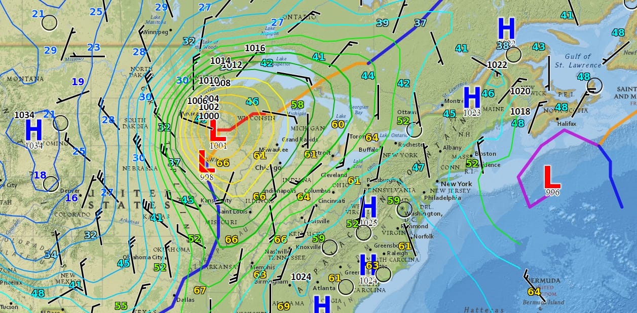
The Atlantic ocean storm which really looks impressive this morning, continues to block the Midwest system from moving eastward to quickly but that block will break down shortly and the cold front with that storm will arrive here Saturday night.


In the meantime radars here remain nice and quiet. Sunshine today will boost temperatures into the 60s except right along the immediate coast where it will be a bit cooler with a northerly flow. Tonight will be another nice clear night and most of Saturday will be sunny with highs in the 60s until the front arrives with clouds and showers Saturday night into Sunday morning.
Colder air on gusty northwest winds will dominate Sunday into Tuesday morning with temperatures settling into the 40s Sunday and the upper 30s and lower 40s Monday and Tuesday. There could be some rain or snow showers around Sunday in some areas and again on Monday. It is possible that some areas could get the ground whitened up a little depending on how squally in nature these snow showers get.
SNOW REMOVAL COMPANIES FOR YOUR WINTER NEEDS
LONG ISLAND ROCKLAND COUNTY Connecticut

![]()

FiOS1 News Weather Forecast For Long Island
FiOS1 News Weather Forecast For New Jersey
FiOS1 News Weather Forecast For Hudson Valley
NATIONAL WEATHER SERVICE SNOW FORECASTS
LATEST JOESTRADAMUS ON THE LONG RANGE
Weather App

Don’t be without Meteorologist Joe Cioffi’s weather app. It is really a meteorologist app because you get my forecasts and my analysis and not some automated computer generated forecast based on the GFS model. This is why your app forecast changes every 6 hours. It is model driven with no human input at all. It gives you an icon, a temperature and no insight whatsoever.
It is a complete weather app to suit your forecast needs. All the weather information you need is right on your phone. Android or I-phone, use it to keep track of all the latest weather information and forecasts. This weather app is also free of advertising so you don’t have to worry about security issues with your device. An accurate forecast and no worries that your device is being compromised.
Use it in conjunction with my website and my facebook and twitter and you have complete weather coverage of all the latest weather and the long range outlook. The website has been redone and upgraded. Its easy to use and everything is archived so you can see how well Joe does or doesn’t do when it comes to forecasts and outlooks.
Just click on the google play button or the apple store button on the sidebar for my app which is on My Weather Concierge. Download the app for free. Subscribe to my forecasts on an ad free environment for just 99 cents a month.
Get my forecasts in the palm of your hand for less than the cost of a cup of Joe!


