
Snow This Weekend Still No Weather Model Clarity

Snow This Weekend Still No Weather Model Clarity
As we said in an earlier post today, don’t expect any clarity from me regarding this system for late this week. While some may have it all figured out already, that’s great. I don’t. First off let me just say that what we are seeing is really not model “flip flopping” but rather, each model run is creating a slightly different scenario regarding how the upper air aligns itself in the east and the strength of the northern part of the jet stream verses the south. Here is what we have seen in the last 4 model runs.
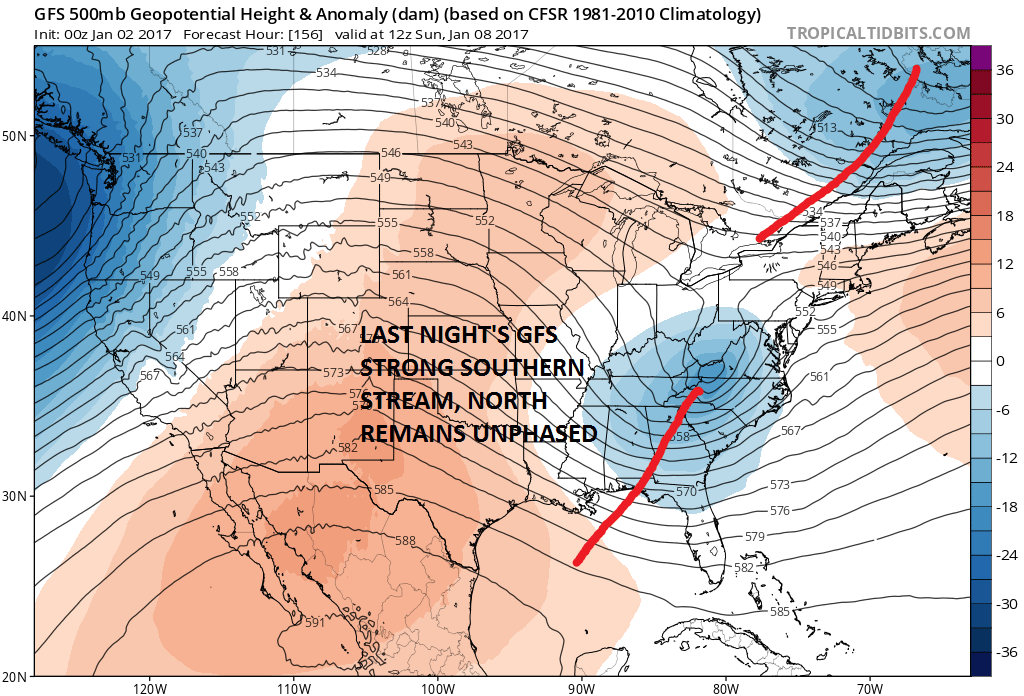
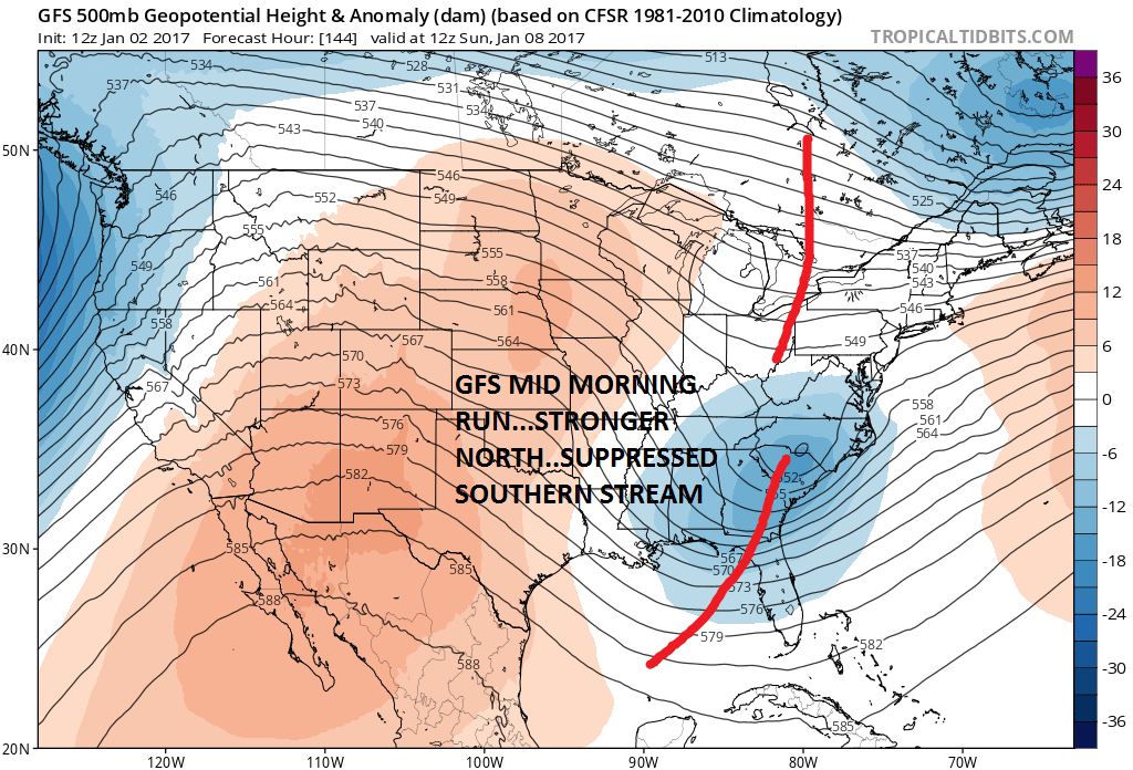
The two main cycle runs from 0z & 12z today show 2 looks with the dynamic overnight run (0z) giving way to the further south and suppressed southern stream 12z run. Now the two mid cycle runs have their own views on this as well.
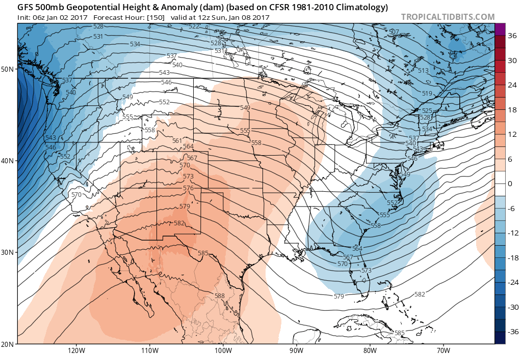
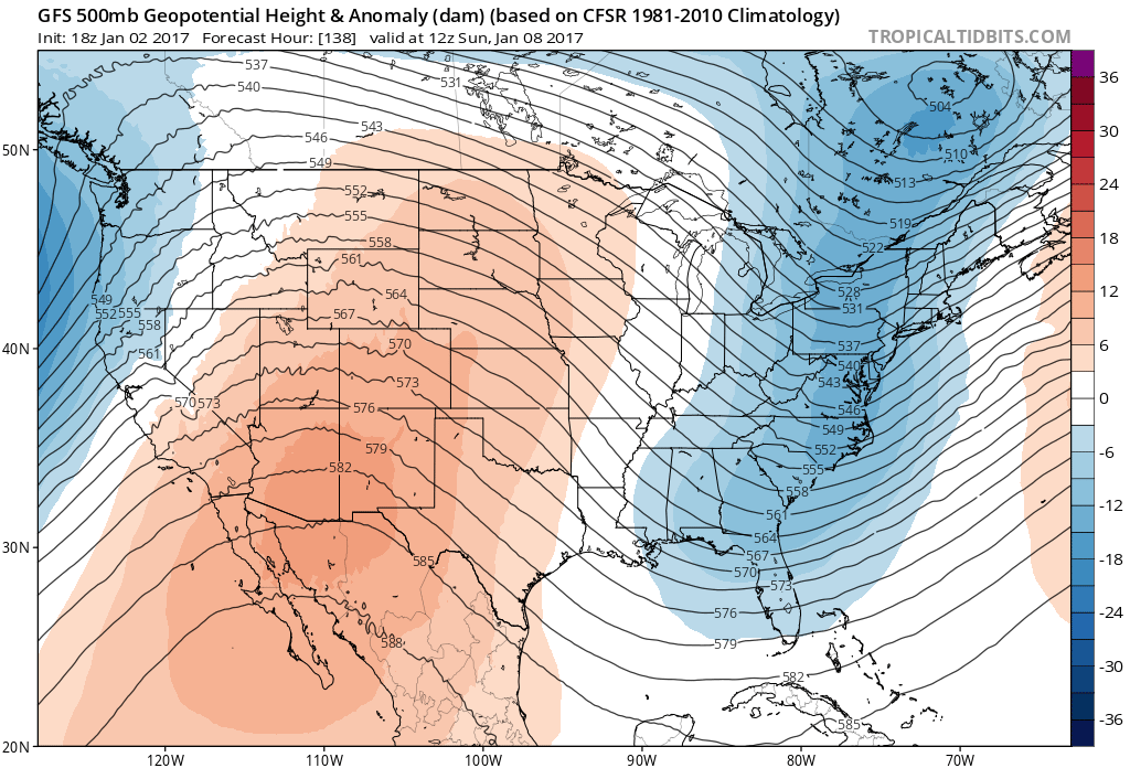
Now comes the mid cycle runs which attempt to phase north and south. The 6z model run would be a complete miss for the Northeast and would bring snow to southern areas of the Middle Atlantic States. The deeper 18z run today is phased and left which actually brings some snow back as far north as Southern New England.

So at this point we continue to state that until models figure out what is really happening here, we take an agnostic view of this for at least another day or so. There is has been too much model volatility in this forecast range. I’m still waiting for the Wisconsin Blizzard from last month that never happend among others. I think the threat is there but the forecast outcome is way to early in the game to determine. I would remind everyone that we were at this very point last year before the blizzard along with countless other storms over the years. Many model runs to go!
MANY THANKS TO TROPICAL TIDBITS FOR THE USE OF THE WONDERFUL MAPS
SNOW REMOVAL COMPANIES FOR YOUR WINTER NEEDS
LONG ISLAND ROCKLAND COUNTY Connecticut

![]()

ROCKLAND COUNTY TRI STATE SNOW REMOVAL JOHNSTOWN PA


FiOS1 News Weather Forecast For Long Island
FiOS1 News Weather Forecast For New Jersey
FiOS1 News Weather Forecast For Hudson Valley
NATIONAL WEATHER SERVICE SNOW FORECASTS
LATEST JOESTRADAMUS ON THE LONG RANGE
Weather App

Don’t be without Meteorologist Joe Cioffi’s weather app. It is really a meteorologist app because you get my forecasts and my analysis and not some automated computer generated forecast based on the GFS model. This is why your app forecast changes every 6 hours. It is model driven with no human input at all. It gives you an icon, a temperature and no insight whatsoever.
It is a complete weather app to suit your forecast needs. All the weather information you need is right on your phone. Android or I-phone, use it to keep track of all the latest weather information and forecasts. This weather app is also free of advertising so you don’t have to worry about security issues with your device. An accurate forecast and no worries that your device is being compromised.
Use it in conjunction with my website and my facebook and twitter and you have complete weather coverage of all the latest weather and the long range outlook. The website has been redone and upgraded. Its easy to use and everything is archived so you can see how well Joe does or doesn’t do when it comes to forecasts and outlooks.
Just click on the google play button or the apple store button on the sidebar for my app which is on My Weather Concierge. Download the app for free. Subscribe to my forecasts on an ad free environment for just 99 cents a month.
Get my forecasts in the palm of your hand for less than the cost of a cup of Joe!
![]()
