Soaking Rain Tuesday Colder Late Week
Soaking Rain Tuesday Colder Late Week
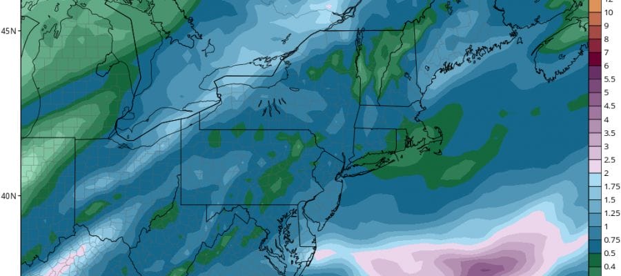
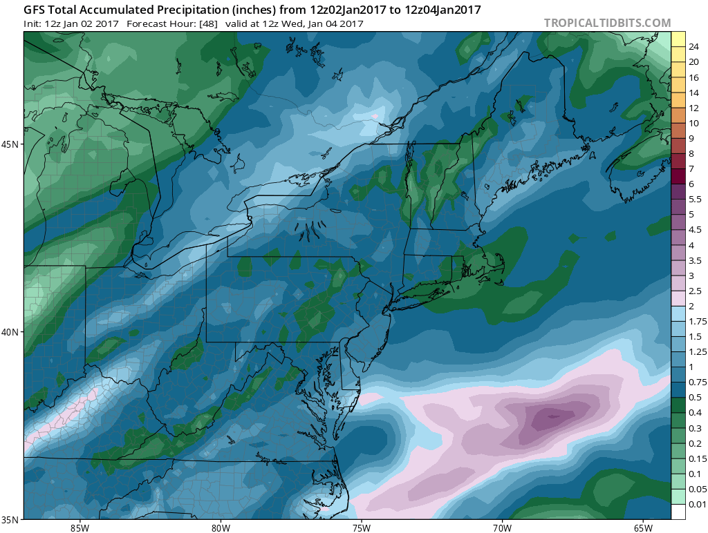
The first round of rain is beginning to slide out to the east. Much of the rain is light. The freezing precipitation is over with now that temperatures have risen above 32 everywhere. With a northeast wind from a high to the northeast, it will keep things raw and damp overnight with temperatures holding in the upper 30s to lower 40s along with some light rain and drizzle.


Tuesday we will see a second round of rain moving in from mid to late morning and continuing into Tuesday evening before moving away to the northeast. Temperatures will be in the 40s to some lower 50s southern areas as low pressure develops just offshore and moves away to the northeast. Rainfall amounts will be in the 1/2 inch to 1 inch range.
Wednesday will still be mild at the start but colder air arrives later in the day and we will be down in the 20s by Thursday morning and not much above the low to mid 30s for highs Thursday. Friday through Sunday will be cold regardless of whether we see snow or not with highs just into the 30s and lows in the teens to lower 20s.
Now with regards to the weather systems for late this week, there has been no material change in the model runs which have been showing a storm to the south moving offshore. I didn’t expect a change based on my earlier post regarding model behavior. I don’t think we will know anything for sure for another day or two. We will update this later today.
SNOW REMOVAL COMPANIES FOR YOUR WINTER NEEDS
LONG ISLAND ROCKLAND COUNTY Connecticut

![]()

ROCKLAND COUNTY TRI STATE SNOW REMOVAL JOHNSTOWN PA


FiOS1 News Weather Forecast For Long Island
FiOS1 News Weather Forecast For New Jersey
FiOS1 News Weather Forecast For Hudson Valley
NATIONAL WEATHER SERVICE SNOW FORECASTS
LATEST JOESTRADAMUS ON THE LONG RANGE
Weather App

Don’t be without Meteorologist Joe Cioffi’s weather app. It is really a meteorologist app because you get my forecasts and my analysis and not some automated computer generated forecast based on the GFS model. This is why your app forecast changes every 6 hours. It is model driven with no human input at all. It gives you an icon, a temperature and no insight whatsoever.
It is a complete weather app to suit your forecast needs. All the weather information you need is right on your phone. Android or I-phone, use it to keep track of all the latest weather information and forecasts. This weather app is also free of advertising so you don’t have to worry about security issues with your device. An accurate forecast and no worries that your device is being compromised.
Use it in conjunction with my website and my facebook and twitter and you have complete weather coverage of all the latest weather and the long range outlook. The website has been redone and upgraded. Its easy to use and everything is archived so you can see how well Joe does or doesn’t do when it comes to forecasts and outlooks.
Just click on the google play button or the apple store button on the sidebar for my app which is on My Weather Concierge. Download the app for free. Subscribe to my forecasts on an ad free environment for just 99 cents a month.
Get my forecasts in the palm of your hand for less than the cost of a cup of Joe!


