
Snow Tonight Not Impressive

WINTER WEATHER ADVISORY IN EFFECT FROM SOUTHEASTERN PENNSYLVANIA NORTHEAST THROUGH SOUTHERN NEW ENGLAND
Looking at the satellite and radar loops this afternoon the area of snow developing to the south looks rather unimpressive overall. Surface observations show a small area of moderate to heavy snow concentrated in Southeast Pennsylvania with only a handful of stations like Lancaster PA, & Harrisburg PA reporting accumulating snow. Other areas are reporting steady light snow but Philadelphia has been cloudy for hours and they are now beginning to report some snow.
One of the things that is happening is that if you look offshore there is a cluster of clouds racing eastward. Low pressure is developing offshore and moving northeastward. It is taking moisture away from the coast leaving the upper air disturbance not much to work on.
Snow Tonight Not Impressive Satellite & Radar Loops


Such is the issue with sytems like this. You are left to work with the upper air dynamics and the snow becomes more convective looking. The radar might look like it does in the spring with just broken clusters of rain showers. This makes the forecast tricky because this is the sort of situation where if you get underneath something with a little power to it you could get a burst of snow that puts down a quick inch or two while other areas get little or nothing. This is the way I’m going to play this for tonight. There could be bursts of snow that could produce a coating to an inch or two and other areas get nothing. Short range models continue to show a weakening trend with all this.
Snow Tonight Not Impressive NAM MODEL & HRRR MODEL

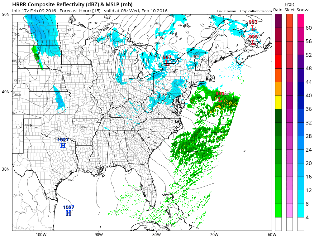
Now the NAM looks worse than it is. It develops a low and a small cluster of snow but precipitation being indicated is light. Same for the HRRR model which at 4am Wednesday morning shows very little snow and forecasts the main area to fall apart.
For now the area of snow over Southern Pennsylvania and Southern New Jersey will move north this evening and then gradually weaken as it continues northeast. We will have to see if the system somehow gets a little energy to it overnight. There is just too many little weather systems running around aloft that nothing serious can get going.
NATIONAL WEATHER SERVICE SNOW FORECASTS
LATEST JOESTRADAMUS ON THE LONG RANGE
Weather App

Winter is here! Don’t be without Meteorologist Joe Cioffi’s weather app. It is a complete weather app to suit your forecast needs. All the weather information you need is right on your phone. Android or I-phone, use it to keep track of all the latest weather information and forecasts. This weather app is also free of advertising so you don’t have to worry about security issues with your device. An accurate forecast and no worries that your device is being compromised.
Use it in conjunction with my website and my facebook and twitterand you have complete weather coverage of all the latest weather and the long range outlook. The website has been redone and upgraded. Its easy to use and everything is archived so you can see how well Joe does or doesn’t do when it comes to forecasts and outlooks.
Just click on the google play button or the apple store button on the sidebar for my app which is onMy Weather Concierge. Download the app for free. Subscribe to my forecasts on an ad free environment for just 99 cents a month.
Get my forecasts in the palm of your hand for less than the cost of a cup of Joe!
![]()
