
DOWNLOAD MY NEW FREE JOESTRADAMUS WEATHER APP FOR ANDROID
THE APP IS ABSOLUTELY FREE TO ALL BUT CONSIDERING SUBSCRIBING TO PATREON FOR A WEATHER EXPERIENCE FREE OF ADS, EXCLUSIVE VIDEOS FOR MEMBERS ONLY AND MUCH MORE…STARTS AT $2 A MONTH..MESSAGE ME AT ANY TIME
Snow Tonight Coating to 2 Inches Ice Storm Threat Grows Weekend
The first of 2 weather systems will be arriving tonight into Friday morning and there really isn’t much change to the outcome regarding this system. High clouds are already beginning to arrive and they will increase and thicken up today. We are in the 20s this morning but with the clouds and a cold high to the north temperatures are going to struggle today back to the upper 20s and lower 30s and that should be it. There will be no snow for the evening commute. Snow will begin long after the evening commute is over.
EASTERN SATELLITE

REGIONAL RADAR

Regional & local radars remain free and clear of any snow at the moment and should start to load up a bit this evening across Pennsylvania. Snow will arrive at the New Jersey/Pennsylvania state line at about 10pm and then reach NYC to Western Connecticut and Long Island around midnight. By 6am the back edge will be at the PA/NJ state line and done on the east flank by 8am or so. There could be a little mixing or some rain getting involved along the immediate coast. If there isn’t much wind tonight, most areas could hold this as snow.
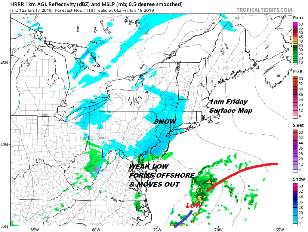
Yesterday’s final call map remains the same for today. I didn’t see any reason to change it. This is a minor event from start to finish so i’m not going to get all worked up over whether one spot gets a coating and one spot outperforms over 2″ It is snow..it’s light…clear it with a broom…and on to the next one.

Now on to the Saturday night Sunday debacle in which we continue to watch and see where and how the temperature boundary sets up. This is a situation where the cold surface high to the north in Canada will bleed cold air southward creating a real struggle with the 32 degree line and how far north it gets. It may get to NYC or just north of NYC and then come to a grinding halt. I think this sets up for a front end thumping of snow Saturday night that goes to sleet and freezing rain Sunday morning and then back to ice and snow for a short time Sunday afternoon. This is going to be one that we have to dissect into multiple parts and will have to break it down in more detail later today.
There is additional coverage on the weekend storm on my weather platform on Patreon.
MANY THANKS TO TROPICAL TIDBITS FOR THE USE OF MAPS
Please note that with regards to any tropical storms or hurricanes, should a storm be threatening, please consult your local National Weather Service office or your local government officials about what action you should be taking to protect life and property.


