Snow Threat Possible Next Weekend?

Snow Threat Possible Next Weekend?
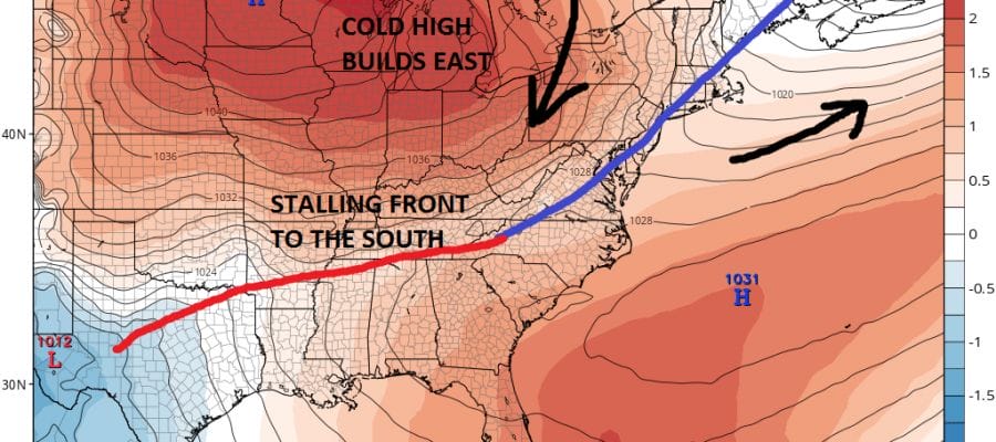
Even though we will see rather mild temperatures Wednesday and Thursday of this week, let’s jump to Friday as we begin to see a possible set up for a small overrunning event for late Saturday into Sunday morning. Weather models have been showing this for several days and have barely budged on the idea other than adjusting a little further south or a little further north. Today’s models adjusted a little further to the south.

We are using the European model on this post but all the models agree on a cold front coming through Friday morning and a big strong high building east across the Great Lakes into upstate NY and New England. To the south the front stalls out. This creates a zone of overrunning to the south and west as colder air builds into the Northeast and down the coast. Now what models are forecasting is a little wave develops on that front and moves east.
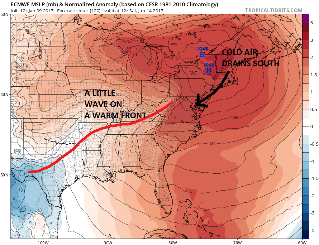
You can barely find the wave here and in fact you can’t even find it at the higher levels of the atmosphere. The overrunning set up of warm air coming east over the cold air wedged in place in the northeast will allow an area of snow and ice to develop in the Ohio Valley and move eastward. The European would suggest the potential for several inches Saturday night into Sunday morning in an area in New Jersey north of Route 195 and continuing northeastward and northward into Eastern Pennsylvania and much of Southeast NY Long Island and Connecticut. This is a small system and right now we are just in the watch and wait phase. But the threat is there. The main low back in Texas will eventually move northeast to the Great Lakes Sunday night and Monday. The one thing that could change that is that the NAO index is forecast to begin trending toward neutral early next week. This could allow a more south and east track with system number 2 however there may not be much cold air to play with at that point. Lots of variables in the equation so we will just sit back and watch to see how this evolves at this point.
MANY THANKS TO TROPICAL TIDBITS FOR THE WONDERFUL USE OF THE MAPS
SNOW REMOVAL COMPANIES FOR YOUR WINTER NEEDS
LONG ISLAND ROCKLAND COUNTY Connecticut

![]()

ROCKLAND COUNTY TRI STATE SNOW REMOVAL JOHNSTOWN PA


FiOS1 News Weather Forecast For Long Island
FiOS1 News Weather Forecast For New Jersey
FiOS1 News Weather Forecast For Hudson Valley
NATIONAL WEATHER SERVICE SNOW FORECASTS
LATEST JOESTRADAMUS ON THE LONG RANGE
Weather App

Don’t be without Meteorologist Joe Cioffi’s weather app. It is really a meteorologist app because you get my forecasts and my analysis and not some automated computer generated forecast based on the GFS model. This is why your app forecast changes every 6 hours. It is model driven with no human input at all. It gives you an icon, a temperature and no insight whatsoever.
It is a complete weather app to suit your forecast needs. All the weather information you need is right on your phone. Android or I-phone, use it to keep track of all the latest weather information and forecasts. This weather app is also free of advertising so you don’t have to worry about security issues with your device. An accurate forecast and no worries that your device is being compromised.
Use it in conjunction with my website and my facebook and twitter and you have complete weather coverage of all the latest weather and the long range outlook. The website has been redone and upgraded. Its easy to use and everything is archived so you can see how well Joe does or doesn’t do when it comes to forecasts and outlooks.
Just click on the google play button or the apple store button on the sidebar for my app which is on My Weather Concierge. Download the app for free. Subscribe to my forecasts on an ad free environment for just 99 cents a month.
Get my forecasts in the palm of your hand for less than the cost of a cup of Joe!
![]()
