Snow Threat Increases For Thursday
Snow Threat Increases For Thursday
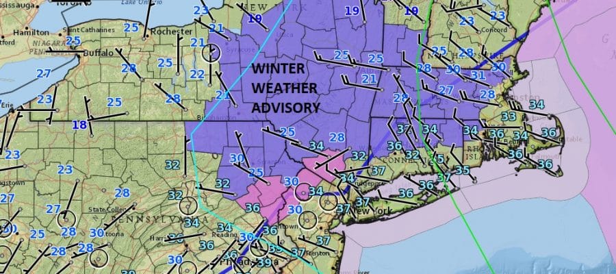
Overnight weather models continue to come on board to the idea of a snow or rain changing over to accumulating snow situation for much of the area from Southern New Jersey to Southern New England and everyone in between. Firstly we have a rain event for Tuesday which the National Weather Service has put up Freezing Rain Advisories for the NW counties of New Jersey. Winter Weather Advisories are posted for Dutchess, Ulster, and Sullivan Counties northward. Also advisories are posted for Northern Connecticut north of Route 84. Frankly I’m not sure why they are up so far south but I guess it is to cover for the possibility there is some minor icing but that’s all it will be.

This morning we see dry air and sunshine as skies are clear for now. Clouds will start to arrive late today and thicken up tonight as low pressure heads for the Eastern Great Lakes. Rain comes in for tomorrow and it should be out by late afternoon or evening. One or two more showers overnight Tuesday and then Wednesday we sit in leftover clouds and some breaks of sun.
SATELLITE LOOP

REGIONAL RADAR

LOCAL RADAR NEW YORK CITY

LOCAL RADAR PHILADELPHIA


It appears at this point that the front will stall out and a wave develops on it Wednesday night into Thursday. Colder air will be coming in at the same time so it appears to be a snow or rain changing to snow situation. We discussed yesterday what the issues are here with regards to timing. Last night’s model runs were very aggressive in terms of snow amounts especially the GFS model while the European was colder and southeast which would bring more snow for the coast than inland. The usual arguments play out here but right now I’m thinking this could be several inches or more for everyone along and north of Route 195 in New Jersey. This is going to be dependent on the timing of the arrivial of colder air and the development of the wave so there is a delicate balance here. Also the depth of the low comes into question as some models were a bit more aggressive with development than others. We have time to see this evolve and will update this later today.
SNOW REMOVAL COMPANIES FOR YOUR WINTER NEEDS
LONG ISLAND ROCKLAND COUNTY Connecticut

![]()

ROCKLAND COUNTY TRI STATE SNOW REMOVAL JOHNSTOWN PA


FiOS1 News Weather Forecast For Long Island
FiOS1 News Weather Forecast For New Jersey
FiOS1 News Weather Forecast For Hudson Valley
NATIONAL WEATHER SERVICE SNOW FORECASTS
LATEST JOESTRADAMUS ON THE LONG RANGE
Weather App

Don’t be without Meteorologist Joe Cioffi’s weather app. It is really a meteorologist app because you get my forecasts and my analysis and not some automated computer generated forecast based on the GFS model. This is why your app forecast changes every 6 hours. It is model driven with no human input at all. It gives you an icon, a temperature and no insight whatsoever.
It is a complete weather app to suit your forecast needs. All the weather information you need is right on your phone. Android or I-phone, use it to keep track of all the latest weather information and forecasts. This weather app is also free of advertising so you don’t have to worry about security issues with your device. An accurate forecast and no worries that your device is being compromised.
Use it in conjunction with my website and my facebook and twitter and you have complete weather coverage of all the latest weather and the long range outlook. The website has been redone and upgraded. Its easy to use and everything is archived so you can see how well Joe does or doesn’t do when it comes to forecasts and outlooks.
Just click on the google play button or the apple store button on the sidebar for my app which is on My Weather Concierge. Download the app for free. Subscribe to my forecasts on an ad free environment for just 99 cents a month.
Get my forecasts in the palm of your hand for less than the cost of a cup of Joe!


