DOWNLOAD MY NEW FREE JOESTRADAMUS WEATHER APP FOR ALL DEVICES
THE APP IS ABSOLUTELY FREE TO ALL BUT CONSIDERING SUBSCRIBING TO PATREON FOR A WEATHER EXPERIENCE FREE OF ADS, EXCLUSIVE VIDEOS FOR MEMBERS ONLY AND MUCH MORE…STARTS AT $2 A MONTH..MESSAGE ME AT ANY TIME
Snow Sleet Rain Tonight Saturday Morning More Snow Late Sunday
Our overnight system performed in most areas as advertised so now it is on to toniight’s challenge an it is indeed a challenge. This storm system is going to rev up late this afternoon and tonight over Virginia and then strengthen and then move to the northeast. This storm is extremely important because its developement will hold the key to Sunday night into Monday morning. The more developed this storm is, the further south the storm for Sunday tracks.
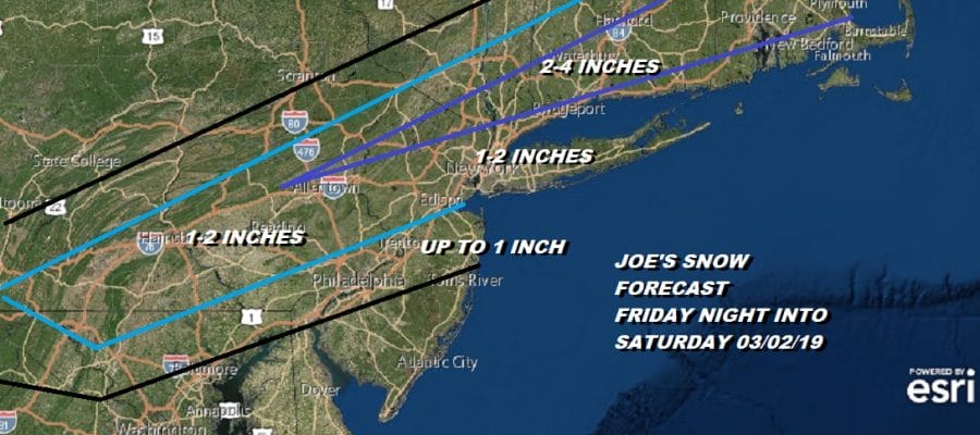
This was my early call for tonight into Saturday morning from yesterday and I am holding on to this for the time being. The temperatures in the 1 to 2 inch zone are so borderline that those amounts could easily be double. I have included a band of 2 to 4 inches that begins to expand across Northern New Jersey northeastward through Connecticut. Those numbers could go higher as well. For now this works and we wait for later today.
EASTERN SATELLITE
REGIONAL RADAR
Today’s sysntem is now pulling out to the east on the radar and continues to plod along so weather conditions are going to improve going forward but there will be lots of leftover clouds around. Then we will start to look for development of precipitation for tonight’s low. Temperatures today will be mostly in the 30s.
LOCAL RADAR NEW YORK CITY
LOCAL RADAR PHILADELPHIA

Tonight we will be cloudy and snow will develop. There will be a sharp snow/sleet/rain line with this system and the upper air conditions are about as borderline as you can get across Central NJ, NYC & Long Island. Southern New England could get a solid snow fall out of this and I expect this system to outperform across Connecticut and it might be all the way down to the coast. Snow develops late this evening from south to north and then a change to rain follows that only gets so far north. It may come to a grinding halt somewhere over NYC/Long Island Sound or near by. There also could be a period of sleet in a transition zone. It all winds down Saturday morning around daybreak.
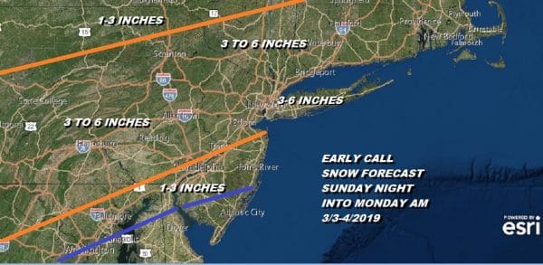
Now on to late Sunday into Monday. I discussed at length yesterday on various posts regarding the importance of this lead system to the system for Sunday night and Monday. Various models are coming around (some faster than others) to a more suppressed, further south, weaker solution and this is where I’m at this morning. Models can still move around a bit today and tonight so expect more mindless chatter and emotional ups and downs but the bottom line is we know what we are looking for with regards to our forecast ideas here. Facebook fan supporters and Patreon members got my very early speculative call for Sunday and now here it is for all to view.
The area of 3 to 6 is a broad one and I expect this to narrow somewhat. I also think this would be the max numbers so if you are hearing ridiculous numbers out there, it is exactly what they are..ridiculous. The more suppressed this is the more likely snow amounts will fall down toward the lower end of the ranges here rather than the higher end. None of this starts until later Sunday afternoon and it is done by Monday morning.
In the meantime Saturday we should see some improvement with clouds and some breaks of sunshine with highs in the 30s. Sunday it will cloud up and snow will arrive late in the day and will be gone by daybreak Monday. For now we just watch and wait. We will fill in all the details after we get done with tonight and Saturday morning.
MANY THANKS TO TROPICAL TIDBITS FOR THE USE OF MAPS
Please note that with regards to any tropical storms or hurricanes, should a storm be threatening, please consult your local National Weather Service office or your local government officials about what action you should be taking to protect life and property.


