DOWNLOAD MY APP FOR FREE & CONSIDER JOINING PATREON

THE APP IS ABSOLUTELY FREE TO ALL BUT CONSIDERING SUBSCRIBING TO PATREON FOR A WEATHER EXPERIENCE FREE OF ADS, EXCLUSIVE VIDEOS FOR MEMBERS ONLY AND MUCH MORE…STARTS AT $2 A MONTH..MESSAGE ME AT ANY TIME
Winter Weather Advisory Southwest New Jersey Southern Pennsylvania
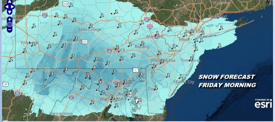
We have Winter Weather Advisories posted for tonight’s relatively weak weather system that is moving northeast out of the Ohio Valley. This system will be slowly weakening as it moves eastward and during tomorrow morning after daybreak the snow will diminish rather quickly. This is another system that is bringing more snow to the south of NYC and not much of anything to the north and northeast. A few inches of snow are possible from Philadelphia to just north and west of Baltimore and Washington DC.

No advisories are posted for the area surrounding NYC. Here the snow should be minimal at an inch or less. This map shows that it is important to check time stamps. This office has opted to combine snowfalls from all three weather systems that are going to impact the area over the next 4 days. The forecast indicated here is NOT for tonight. Again only a coating to an inch is expect for tonight into Friday morning.
SNOW FORECAST MAPS
New York City, Ne NJ, HV, LI, Coastal Ct
NEW JERSEY & PARTS OF NE PA
The Mount Holly National Weather Service has Winter Weather Advisories posted for the counties in Southwest New Jersey and Southeastern Pennsyvlania as the map above shows. A 1 to 2 inch snowfall is predicted here with higher amounts into Delaware and Northeastern Maryland where advisories are also posted.

CENTRAL & SOUTH CENTRAL PA
Advisories are posted for the southern part of this zone with amounts of 1 to as much as 3 or 4 inches possible with the highest amounts to the south. The area of precipitation will be moving into this area tonight and snow will be developing from west to east around or after midnight. It should be done before daybreak.

VIRGINIA & MARYLAND
This area is under a Winter Weather Advisory and the northern parts of Virginia into Western Maryland and northern West Virginia could see the most from this with a large area indicated to get 3 to 4 inches out of this. Snow amounts near Washington Dc and Baltimore will be less but a few inches are possible in these cities.

Please be advised that these are National Weather Service Forecast Maps and they auto update. Each office may update at different times and some offices are slower to update then others. Maps are usually updated before 5am and & 5pm however they may be updated at other times depending on forecast conditions. These are not my forecasts. My forecasts can be found on the JOE’S SNOWFORECAST PAGE. Individual forecasts for specific areas may also be found when conditions warrant on the my area forecasts. Those can be found on the website menu. Click on forecasts and then select your specific area.