
Snow Showers Moving Through On Radar Cold Night Cold Friday
SHOP THE JOESTRADAMUS STORE
Snow Showers Moving Through On Radar Cold Night Cold Friday
We are seeing snow showers moving across Eastern Pennsylvania, NW New Jersey and the Hudson Valley this evening. The radar is picking up on all this but they should play through with little consequence and skies should become partly to mostly clear overnight. The front to the south remains stalled and perilously close to us but the high clouds from this should stay away until during the day Friday. Temperatures overnight will settle in the 20s to low 30s. Friday sunshine and arriving clouds will send highs only back to the upper 30s and lower 40s.
SATELLITE LOOP

REGIONAL RADAR

Snow showers are showing up on the local radars. Upstate NY we are seeing lake effect snows going on there and they will continue on and off into next week with some places seeing substantial amounts.
LOCAL RADAR NEW YORK CITY

LOCAL RADAR PHILADELPHIA


Everything appears on course for Saturday. Snow develops around or before day break from NYC south and just after daybreak north and west of the coast. Snow continues into Saturday night before ending. My forecast amounts are a bit lower than models and the National Weather Service but I may beef them up a bit if model trends continue.
JOE’S SNOW FORECAST FOR SATURDAY

Many of you keep bringing up the warm ground which really is nonsense. First off the ground is not all that warm. Second if the snow doesn’t stick it would be due to the lack of intensity and a storm further east. If the warm ground theory really mattered then this snowstorm last winter in February never happened.
HIGHS LOWS & SNOW FALL FEBRUARY 2017
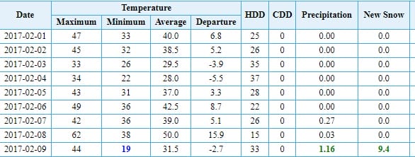
Temperatures in NYC were above freezing for 88 consecutive hours and reached record highs in the low 60s on February 8th only to be followed by 9 inches of snow in NYC on February 9th. Some places nearby got as much as 15 inches on Long Island where apparently some people would say it never snows on the coast.

Once this system is done we will be then dealing with a strong system dropping down out of Canada Tuesday of next week. The European model is especially dynamic with this and this system will bring down very cold air for Tuesday night through next Friday regardless whether it snows again. We will be watching this system very carefully.
 GET JOE A CIGAR IF YOU LIKE

FiOS1 News Weather Forecast For Long Island
FiOS1 News Weather Forecast For New Jersey
FiOS1 News Weather Forecast For Hudson Valley


