
Snow Showers Diminish Warmer Thursday Into Saturday
Showers Saturday Night Into Early Sunday

Weather in 5/Joe & Joe Weather Show Latest Podcast
Snow Showers Diminish Warmer Thursday Into Saturday
Showers Saturday Night Into Early Sunday
The snow showers that peppered (or salted) the area with a sugar coating of snow (in some areas) is diminishing and is all but over in most places. One last flake or two this evening in a couple of isolated spots and then we are done. Skies will clear out overnight as high pressure to the southwest builds in. You don’t have to go far on the satellite to see the clear skies to the southwest.
SATELLITE

REGIONAL RADAR

Leftover snow showers are on the radar as they move from west to east. The drying out process continues. Snow showers from earlier are all offshore and moving away to the east. Once they leave the radar should be quiet into the first half of Saturday at least.
LOCAL RADAR NEW YORK CITY

LOCAL RADAR PHILADELPHIA


A chilly night lies ahead but skies will be clear. Most lows will be in the upper 20s to mid 30s. High pressure builds in for Thursday. We should have a good deal of sunshine. Temperatures will moderate into the upper 40s to around 50 or so in some areas.

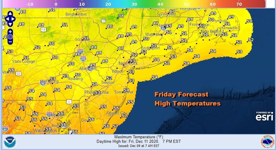
Thursday night will be nice and clear. Friday will be another day of sunshine. Highs Friday will reach up into the low and mid 50s in many areas.
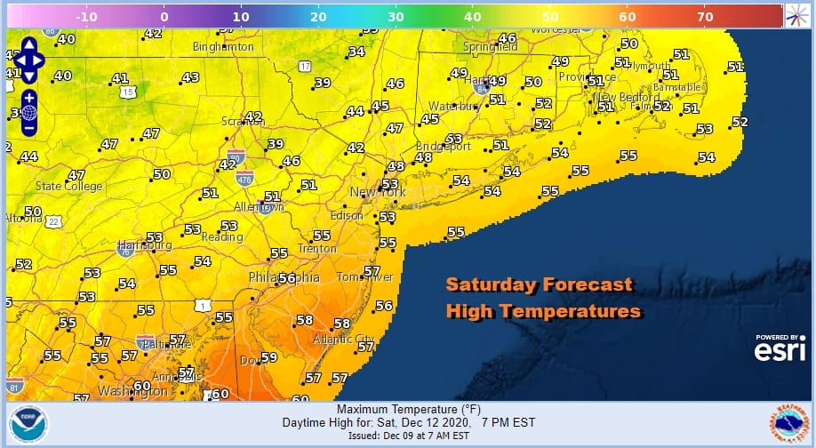
On to the weekend and we see little change in the outlook. Low pressure heads from the Plains to the lower Great Lakes. A cold front swings east with some showers. Right now I think showers hold off until late in the day and then we will have showers at night into Sunday morning. Temperatures Saturday will be in the mid to upper 50s.
There might be showers lingering Sunday morning but they should move out in time to allow for some improvement. Leftover clouds should give way to some sunshine. Temperatures will be in the 50s early and then settle in the 40s.

Next week we will be watching the evolution of the upper pattern. The split flow continues with the northern and southern jets battling for position and timing. The set up might look like the storm from this weekend. Does the north phase with the south or do they stay separate?

The race will be on and so will the changes we will see from run to run. All the models have different solutions as they all have different timing on the two jet streams. In the meantime we can enjoy a couple of nice days ahead.
BE SURE TO DOWNLOAD THE FREE METEOROLOGIST JOE CIOFFI WEATHER APP &
ANGRY BEN’S FREE WEATHER APP “THE ANGRY WEATHERMAN!
MANY THANKS TO TROPICAL TIDBITS FOR THE USE OF MAPS
Please note that with regards to any severe weather, tropical storms, or hurricanes, should a storm be threatening, please consult your local National Weather Service office or your local government officials about what action you should be taking to protect life and property.


