Snow Rain Showers Moving Through Snow Risk Super Bowl Sunday Continues

Weather in 5/Joe & Joe Weather Show Latest Podcast
Snow Rain Showers Moving Through Snow Risk Super Bowl Sunday Continues
We have a cold front moving through this morning and it is producing lots of clouds. We are seeing some rain and snow showers that will be moving through into this afternoon. Not everyone sees them. Some places could see a quick whitening of the ground to at most an inch or so.
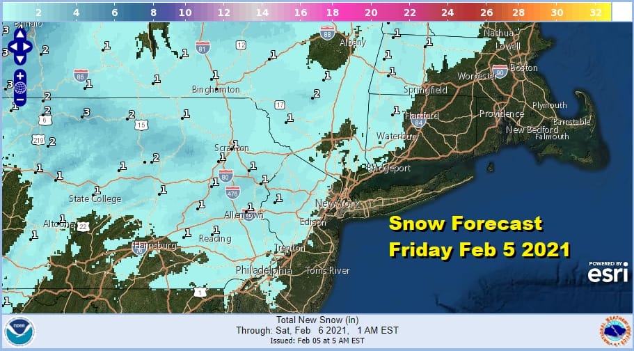
The front shows up well on the satellite picture as this narrow arm swings from west to east. Behind the front we see some breaks in the cloud cover and we should have that over us during the afternoon. Temperatures today will reach the upper 30s and lower 40s. Some places are already near the highs of the day.
SATELLITE

Radars are showing the bands of rain and snow showers moving east. Most of what is on the radar is on the light side. The western edge of the bands remain in full view as they move eastward.
F5 WEATHER RADARS


It will turn a little colder tonight as skies clear out. Lows will be in the 20s in most places. There are no issues Saturday as we will have some sunshine with a west breeze. Highs will be in the 30s to near 40 degrees.
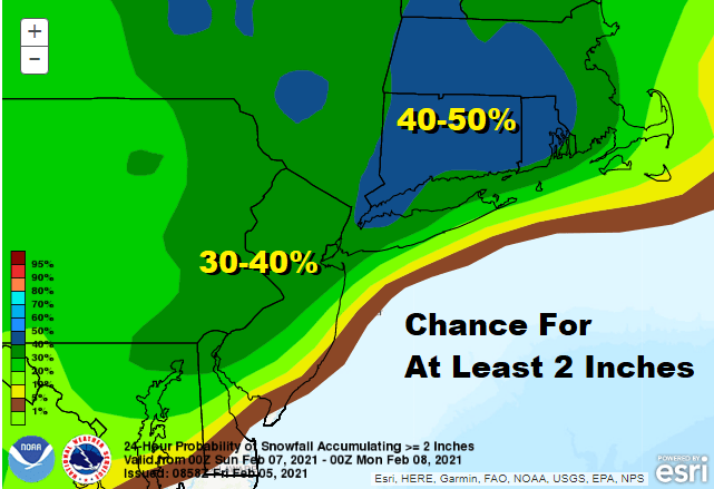
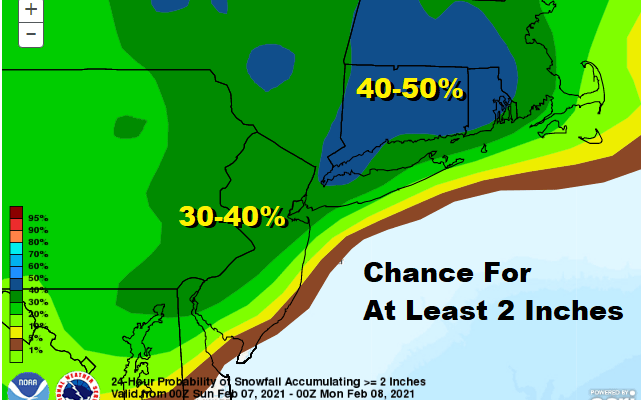
Sunday we have the risk for snow across much of the Northern Mid Atlantic to Southern New England thanks to low pressure that will be moving out of the Southeast and heading up the coast, passing just offshore. How far north the snow gets hinges on the sharpness of this upper trough. Yesterday weather models showed a rather sharp trough lifting up a robust system. Some of the in between model runs have backed off a bit.

My feeling on this yesterday was that this system would be a 3-6/4-8 inch type snowfall for those who lie in the heavier snow bands. This area is yet to be determined so for now we remain the same with our outlook. A weaker system would put us closer to the low end range of those numbers. In other words we would be closer to the 3 or 4 than the 6 or 8. A truly weak system would reduce those numbers further. This is a fast mover which means snow amounts would be limited even in a worst case scenario. There would not be time since this is basically arriving early morning and done by mid afternoon. Temperatures through all this will be in the upper 20s and lower 30s. Early next week will be very cold with some sunshine. Most highs Monday and Tuesday will be in the mid 20s to lower 30s.
BE SURE TO DOWNLOAD THE FREE METEOROLOGIST JOE CIOFFI WEATHER APP &
ANGRY BEN’S FREE WEATHER APP “THE ANGRY WEATHERMAN!
MANY THANKS TO TROPICAL TIDBITS & F5 WEATHER FOR THE USE OF MAPS
Please note that with regards to any severe weather, tropical storms, or hurricanes, should a storm be threatening, please consult your local National Weather Service office or your local government officials about what action you should be taking to protect life and property.


