Snow Rain Arrive Around Daybreak
Snow Rain Arrive Around Daybreak
While we wait for snow and rain to arrive around daybreak, we have clear skies (finally) over us this evening and we should stay clear for at least part of the night. That will allow temperatures to drop off into the 20s and lower 30s before the clouds move in. You can see the clouds out to the west as two distinct areas of short wave energy move east. It won’t look like anything impressive until tomorrow evening when a major storm intensifies in our backyard.


Nothing is on the radar at the moment. Clouds will increase and thicken up and then the precipitation moves in first thing in the morning. For coastal areas and even areas just inland it will be rain pretty much from the get go. Further inland in NJ north and west of 287 and in the Hudson Valley north of 287 it is a brief start as snow and then rain. Accumulations of a few inches will be confined to Northwest NJ like Sussex and Warren Counties and in the Hudson Valley from Putnam and Orange Counties northward. Even these areas will go to rain eventually.
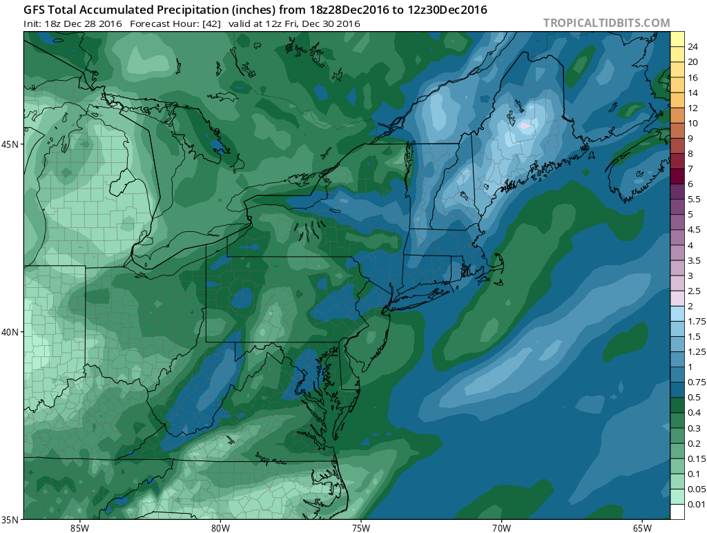
Rain fall amounts are in the 1/2 to 3/4 inch range. I think this could wind up being a little higher and push an inch or so in some areas which continues the drought easing process.

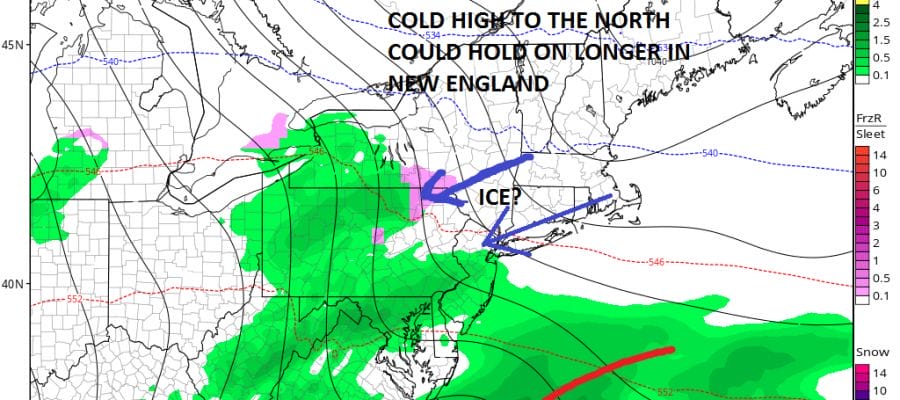
The next weather event is minor on Saturday night with a weak warm front going by. There could be some rain and snow showers with that when it goes by. The more important thing I’m going to be focusing on next is Monday into Monday night. High pressure builds in New England and this could funnel some colder air at lower levels of the atmosphere. The developing block in the atmosphere could hold that high in longer. I think there could be some freezing rain issues late Monday into Monday night especially inland.
For the latest snowfall forecast maps see my latest post on the snow forecasts page.
SNOW REMOVAL COMPANIES FOR YOUR WINTER NEEDS
LONG ISLAND ROCKLAND COUNTY Connecticut

![]()

ROCKLAND COUNTY TRI STATE SNOW REMOVAL jOHNSTOWN PA


FiOS1 News Weather Forecast For Long Island
FiOS1 News Weather Forecast For New Jersey
FiOS1 News Weather Forecast For Hudson Valley
NATIONAL WEATHER SERVICE SNOW FORECASTS
LATEST JOESTRADAMUS ON THE LONG RANGE
Weather App

Don’t be without Meteorologist Joe Cioffi’s weather app. It is really a meteorologist app because you get my forecasts and my analysis and not some automated computer generated forecast based on the GFS model. This is why your app forecast changes every 6 hours. It is model driven with no human input at all. It gives you an icon, a temperature and no insight whatsoever.
It is a complete weather app to suit your forecast needs. All the weather information you need is right on your phone. Android or I-phone, use it to keep track of all the latest weather information and forecasts. This weather app is also free of advertising so you don’t have to worry about security issues with your device. An accurate forecast and no worries that your device is being compromised.
Use it in conjunction with my website and my facebook and twitter and you have complete weather coverage of all the latest weather and the long range outlook. The website has been redone and upgraded. Its easy to use and everything is archived so you can see how well Joe does or doesn’t do when it comes to forecasts and outlooks.
Just click on the google play button or the apple store button on the sidebar for my app which is on My Weather Concierge. Download the app for free. Subscribe to my forecasts on an ad free environment for just 99 cents a month.
Get my forecasts in the palm of your hand for less than the cost of a cup of Joe!


