Winter Weather Advisory Hudson Valley NW NJ NE PA
Winter Weather Advisory Hudson Valley NW NJ NE PA
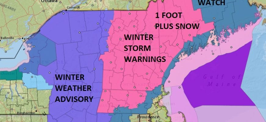
Winter Storm Warning for Much of New England
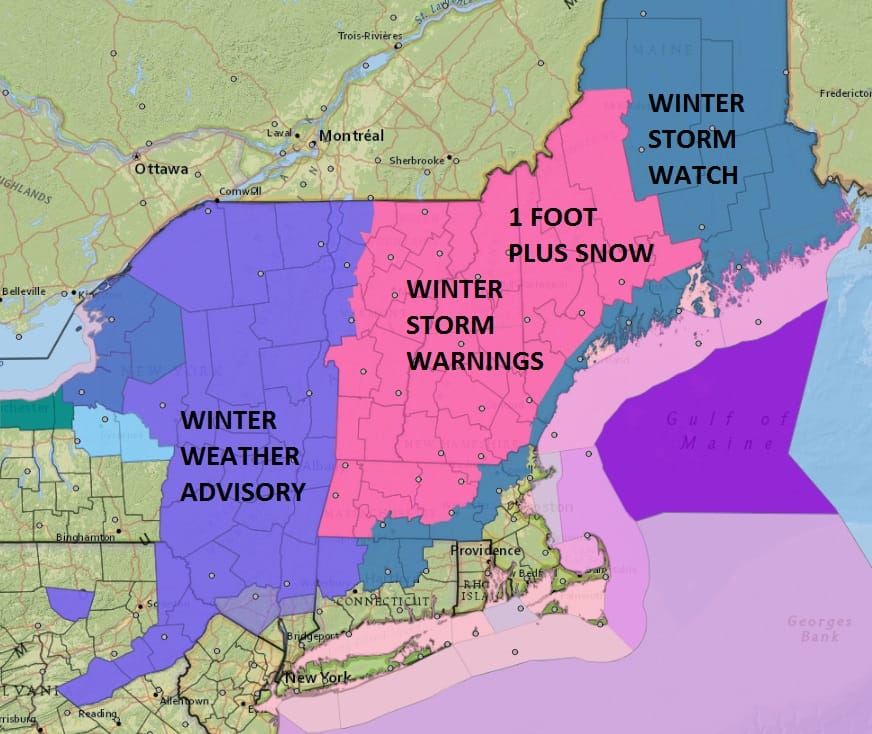
For our area I want to make clear that for the vast majority of the region from Northern New Jersey to New York City, Southern areas of the Hudson Valley and Long Island this is not going to be a problem at all. We will see a quick shot of snow at the start that lasts for an hour or 2 at most and then its rain. Some places near the coast may never see a flake out of this. For Northwest NJ NE Pennsylvania and for the Hudson Valley to about route 84, it will eventually change to rain in those areas with maybe a 1 to at most 3 inch snow fall and the three inches would occur the further north and northwest you go. Even there most of what falls gets washed away or at least slushy.
For much of New England from Western Massachusetts and Eastern Vermont to New Hampshire and Maine this will be a big snowstorm with 12-20 inch amounts in some areas. For much of Eastern New York Winter Weather Advisories are posted for 3 to 6 inch snowfalls north of Kingston and up the Hudson Valley to the Canadian border.
NEW YORK CITY AND VICINITY SNOW

The New York New Jersey Connecticut forecast reflects the warmer air that is coming up from the ocean. This is the reason why coastal areas will see rain pretty much all the way through. Even if these forecast amounts verify it will change to rain throughout the entire forecast region up to at least rt 84 in NY and in Connecticut as well.
NEW YORK CITY & VICINITY ICE

NEW JERSEY & PARTS OF NE PA

For New Jersey warm air will change snow to rain even in the northwestern counties where there could be a few inches. Amounts could be a little higher in parts of Northeastern Pennsylvania.
SOUTHERN AND SOUTHEAST NEW ENGLAND

NORTHERN NEW ENGLAND

WESTERN NEW ENGLAND

MIDDLE AND UPPER HUDSON VALLEY

CENTRAL NEW YORK & NE PA

WESTERN NEW YORK

CENTRAL & SOUTH CENTRAL PA

VIRGINIA & MARYLAND

DAILY NORTHEAST SNOWFALL

Please be advised that these are National Weather Service Forecast Maps and they auto update. Each office may update at different times and some offices are slower to update then others. Maps are usually updated before 5am and & 5pm however they may be updated at other times depending on forecast conditions. These are not my forecasts. My forecasts can be found on the JOE’S SNOWFORECAST PAGE. Individual forecasts for specific areas may also be found when conditions warrant on the my area forecasts. Those can be found on the website menu. Click on forecasts and then select your specific area.
SNOW REMOVAL COMPANIES FOR YOUR WINTER NEEDS
LONG ISLAND ROCKLAND COUNTY Connecticut

![]()


JOHNSTOWN PA
COLOSIMO LAWNCARE
