Snow Mix Monday Night Milder Next Week

Snow Mix Monday Night Milder Next Week
This remarkable stretch of cold weather which of course has now includes a blizzard and the coldest air mass of the stretch moving in this weekend, can’t last forever thankfully. We are going to see a pattern change next week as the Arctic connection breaks down in the jet stream. We will probably transition over to a milder pattern overall and they may include a nice little thaw at some point in the next two weeks. Getting there will not necessarily be a straight line up and there will be a few complications along the way.
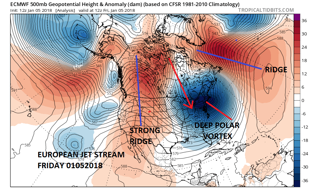
The map above shows the jet stream this morning with the core of the Arctic air right overhead. The flow is straight from the cold Arctic north. The ridges in the west and in the Atlantic are anchoring the cold air in the East for the weekend. However this is going to be breaking down in a hurry early next week.
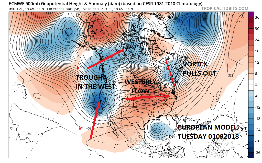
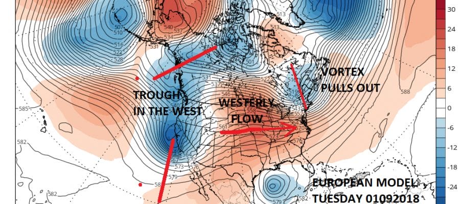
A weak front will approach on Monday with some light precipitation. We could see some light snow or a mix late Monday into Monday night. One factor will be cold surfaces which could mean some glazing that develops with light snow mixed with some sleet and freezing rain. This may wind up being more snow than anything else inland. We will have to watch and see how fast the lower layers of the atmosphere warm on Monday. Cold air is likely to be stubborn since the warmer push of air isn’t anything remarkable. Once that system goes by we will be a regime of seasonal to above average temperatures for awhile as the trough sets up in the Western US for a change.

Late next week there might be some shallow cold air that could get involved with a weather system coming out from the west. High pressure to the north might be a bit more important if the system coming out of the west is weaker and flatter which has been the general trend for the last few months. Some models like the European have been too aggressive with development in the west. The GFS has a more reasonable look. We aren’t too worked up about this at the moment and we will see how models evolve with this over the weekend.
MANY THANKS TO TROPICAL TIDBITS FOR THE WONDERFUL USE OF THE MAPS

GET JOE A CIGAR IF YOU LIKE!
FiOS1 News Weather Forecast For Long Island
FiOS1 News Weather Forecast For New Jersey
FiOS1 News Weather Forecast For Hudson Valley
NATIONAL WEATHER SERVICE SNOW FORECASTS
LATEST JOESTRADAMUS ON THE LONG RANGE
Weather App

Don’t be without Meteorologist Joe Cioffi’s weather app. It is really a meteorologist app because you get my forecasts and my analysis and not some automated computer generated forecast based on the GFS model. This is why your app forecast changes every 6 hours. It is model driven with no human input at all. It gives you an icon, a temperature and no insight whatsoever.
It is a complete weather app to suit your forecast needs. All the weather information you need is right on your phone. Android or I-phone, use it to keep track of all the latest weather information and forecasts. This weather app is also free of advertising so you don’t have to worry about security issues with your device. An accurate forecast and no worries that your device is being compromised.
Use it in conjunction with my website and my facebook and twitter and you have complete weather coverage of all the latest weather and the long range outlook. The website has been redone and upgraded. Its easy to use and everything is archived so you can see how well Joe does or doesn’t do when it comes to forecasts and outlooks.
Just click on the google play button or the apple store button on the sidebar for my app which is on My Weather Concierge. Download the app for free. Subscribe to my forecasts on an ad free environment for just 99 cents a month.
Get my forecasts in the palm of your hand for less than the cost of a cup of Joe!