
Snow Forecasts 01162018 National Weather Service
Snow Forecasts 01162018 National Weather Service
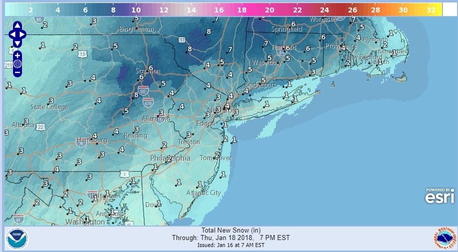
National Weather Service snow forecast maps are up and updated this morning. Amounts have been nudged a bit higher from NYC north and west while taken down somewhat over Long Island especially to the east. There may be just enough warm air at the very bottom of the atmosphere to change snow over to rain over Central and Eastern Long Island and even for a brief time back to about NYC. However just inland of the coast north, northwest, and northeast it will be mostly a wet snow event and much will fall overnight into Wednesday morning making the Wednesday morning commute a mess. Snow has already reached Northeastern Pennsylvania and Northwest New Jersey and should make its way slowly to the east today. areas inland across Northern New Jersey into the Hudson Valley will start up sooner than coastal areas which may not see snow break out until late this evening. Snow will begin to wind down midday in western areas on Wednesday and during the afternoon along the coast and to the east. Areas north of Route 84 stand to see the most snow from this especially in Connecticut.

GET JOE A CIGAR SO HE CAN RELAX!
NEW YORK CITY AND VICINITY SNOW

NEW JERSEY & PARTS OF NE PA

SOUTHERN AND SOUTHEAST NEW ENGLAND

NORTHERN NEW ENGLAND

WESTERN NEW ENGLAND

MIDDLE AND UPPER HUDSON VALLEY

CENTRAL NEW YORK & NE PA

WESTERN NEW YORK

CENTRAL & SOUTH CENTRAL PA

VIRGINIA & MARYLAND

DAILY NORTHEAST SNOWFALL

Please be advised that these are National Weather Service Forecast Maps and they auto update. Each office may update at different times and some offices are slower to update then others. Maps are usually updated before 5am and & 5pm however they may be updated at other times depending on forecast conditions. These are not my forecasts. My forecasts can be found on the JOE’S SNOWFORECAST PAGE. Individual forecasts for specific areas may also be found when conditions warrant on the my area forecasts. Those can be found on the website menu. Click on forecasts and then select your specific area.