DOWNLOAD MY NEW FREE JOESTRADAMUS WEATHER APP FOR ALL DEVICES
THE APP IS ABSOLUTELY FREE TO ALL BUT CONSIDERING SUBSCRIBING TO PATREON FOR A WEATHER EXPERIENCE FREE OF ADS, EXCLUSIVE VIDEOS FOR MEMBERS ONLY AND MUCH MORE…STARTS AT $2 A MONTH..MESSAGE ME AT ANY TIME
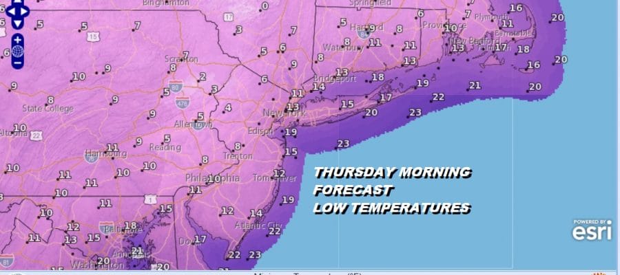
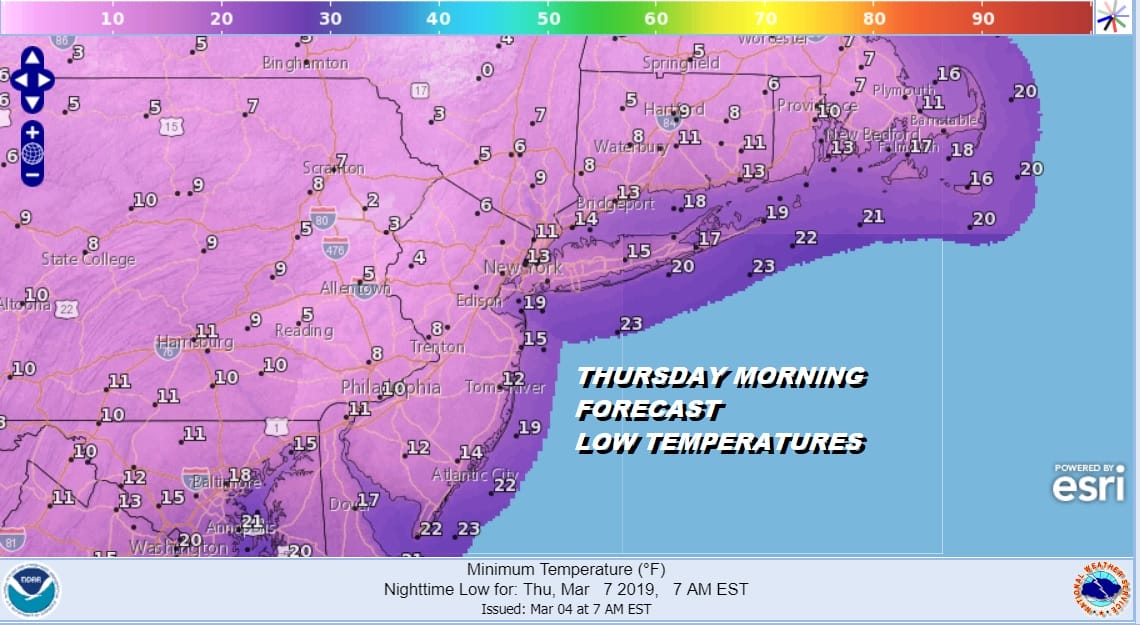
Snow Ends Very Cold Weather Ahead This Week
Last night’s storm system is now long gone to the northeast and we wait for clouds to gradually give way to some sunshine later today. The storm system outperformed for the most part NYC west and north (6 inches +) and under performed over Central and Eastern Long Island ( 3 inches or less). Also in New Jersey it over performed in North Jersey north of Route 22 and in line to under performed south of there. I’m going by my forecast which was much lower (1 to 3 inches) for Central and South Jersey & Southeast Pa. Every snow forecast has this issue and you are never going to get it exactly right for every spot. You do the best you can and move on to the next one. Hopefully this was the last one and there is a fair chance that this is indeed the case and we can look ahead to a spring pattern developing in the long range. That is not going to happen this week as temperatures will average 10 to 15 degrees below average through Thursday. Temperatures in some areas will go below freezing tonight and not see temperatures above 32 until Thursday, especially in areas with deep snow cover.
REGIONAL RADAR

Radar shows the coastal low pulling away to the northeast and local radars are nice and quiet other than the odd snow shower that pops up here and there. There are no precipitation issues over the next few days other than a snow shower chance from time to time and widely scattered at worst.
LOCAL RADAR NEW YORK CITY

LOCAL RADAR PHILADELPHIA


Temperatures today will hold in the 30s and then the cold air that has been sitting just to our northwest moves in. Skies clear out tonight and Tuesday morning lows will be in the teens to lower 20s. Sunshine Tuesday will only bring temperatures back to the upper 20s and lower 30s. Look for a repeat performance Tuesday night and Wednesday and then the coldest night will be Wednesday night into Thursday where low teens and single digits are forecast.
Late this week the coldest air pulls out and we moderate temperature wise. There is a weak system that will head this way for the end of the week with maybe a little rain or snow with that but this doesn’t appear to be anything of consequence. The longer range pattern is one where weather systems move from west to east with shots of colder air followed by warm ups with storms tracking to the west. It would seem given the pattern that the chance for one more snowfall will slowly diminish as each day passes. At least nothing appears to be on the table this week.
MANY THANKS TO TROPICAL TIDBITS FOR THE USE OF MAPS
Please note that with regards to any tropical storms or hurricanes, should a storm be threatening, please consult your local National Weather Service office or your local government officials about what action you should be taking to protect life and property.


