Snow Across Upstate NY New England While
Rain Falls South Colder Sunday Monday

Weather in 5/Joe & Joe Weather Show Latest Podcast
Snow Across Upstate NY New England While
Rain Falls South Colder Sunday Monday
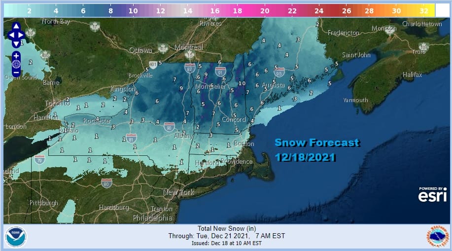
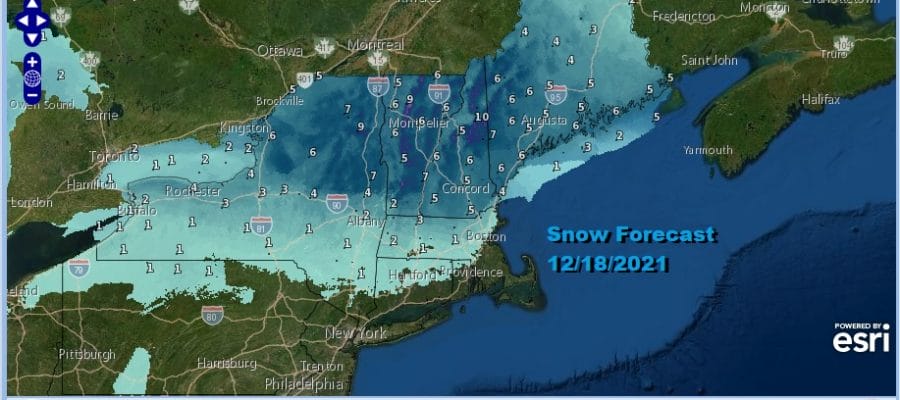
It is a day of cloudy skies. Not much is happening south of Route 78 in New Jersey and Pennsylvania while north of there we have rain and then we we go north of Route 84 we are seeing some snow. There isn’t much change in the forecast from yesterday regarding snow amounts in the I-90 corridor. The southern edge of frozen or freezing precipitation reaches down into Connecticut. Overall we are not looking at much here.
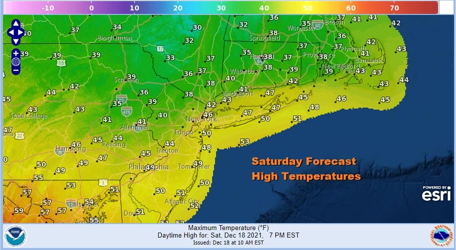
For most of you it is a ho-hum type of day, gloomy and doomy. Clouds are everywhere. The radar is especially busy across Upstate NY and through England. Temperatures this afternoon will range from the 30s north of NYC across the Catskills, Southeast NY into Southern New England while from Southern Pennsylvania to Southern New Jersey south highs will reach into the 50s.
SATELLITE

WEATHER RADAR

Once this system moves out to the east, weather conditions should start to improve tonight. The low to the east and the cold front offshore means winds go around to the northwest and skies should partially clear out late tonight. Most lows tonight will be in the 30s to near 40. Sunday is a day where temperatures likely go nowhere with some sunshine, a gusty wind, but highs only in the lower 40s. Monday’s highs will be in the 30s to around 40.

The week ahead looks very quiet and mostly storm free. The only change is the arrival of a cold front late in the week that brings some colder air for Christmas Eve and Christmas Day but here too models have backed off a little on the extent of the cold. Wednesday night into Thursday low pressure off the Southeast coast heads northeast to usher in this process.
The week will be seasonal and dry. There are no major storms on the horizon and for much of the Eastern US, travel this week will be relatively easy. Longer term still points to a colder pattern for the week going into New Year and beyond but it does not necessarily mean a stormier one. I didn’t see much in the overnight models get me enthused. On the other hand you are better off when the long range models show little or northing since there is a good change that will turn out to be wrong. More weather coming up in updates later today.
BE SURE TO DOWNLOAD THE FREE METEOROLOGIST JOE CIOFFI WEATHER APP &
ANGRY BEN’S FREE WEATHER APP “THE ANGRY WEATHERMAN!

MANY THANKS TO TROPICAL TIDBITS & F5 WEATHER FOR THE USE OF MAPS
Please note that with regards to any severe weather, tropical storms, or hurricanes, should a storm be threatening, please consult your local National Weather Service office or your local government officials about what action you should be taking to protect life and property.


