
Snow Accumulation Forecasts National Weather Service Updated 12302017
Snow Accumulation Forecasts National Weather Service
Updated 12302017
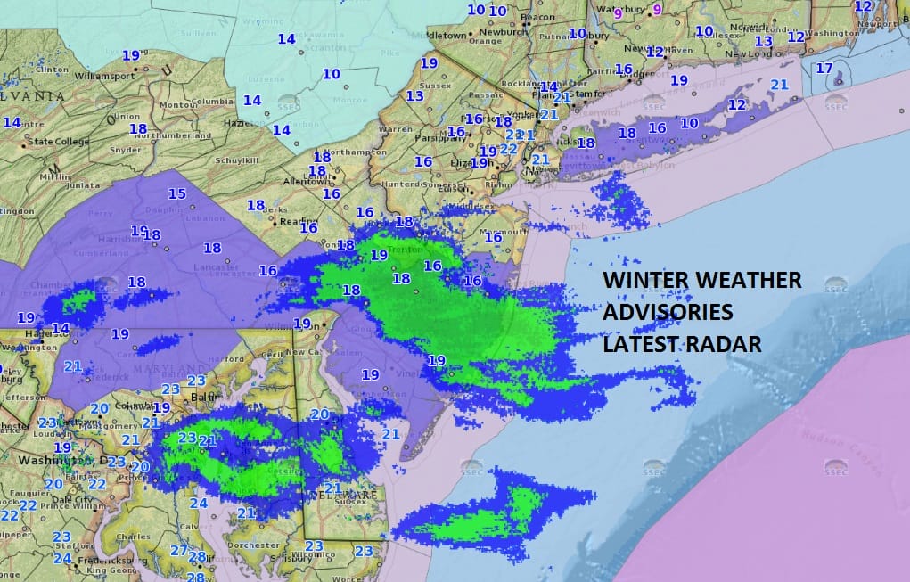
Winter Weather Advisory in effect for Long Island & New Jersey South of Route 195. Latest radars shows where the heaviest snows are falling this morning. This is a light event with a general 1 to 3 inch snowfall forecast in most places. Notice the 8am temperatures are in the teens to near 20 so this snow is powdery and will be easy to clear. Snow will continue into the afternoon and should begin to end from west to east later this afternoon and this evening in areas to the east of NYC. Once the snow is done the next shot of brutally cold air will begin to move in for Sunday and Monday with temperatures by Monday morning in the single digits with a few below zero readings possible.

GET JOE A CIGAR SO HE CAN RELAX!
NEW YORK CITY AND VICINITY SNOW

NEW YORK CITY & VICINITY ICE

NEW JERSEY & PARTS OF NE PA

SOUTHERN AND SOUTHEAST NEW ENGLAND

NORTHERN NEW ENGLAND

WESTERN NEW ENGLAND

MIDDLE AND UPPER HUDSON VALLEY

CENTRAL NEW YORK & NE PA

WESTERN NEW YORK

CENTRAL & SOUTH CENTRAL PA

VIRGINIA & MARYLAND

DAILY NORTHEAST SNOWFALL

Please be advised that these are National Weather Service Forecast Maps and they auto update. Each office may update at different times and some offices are slower to update then others. Maps are usually updated before 5am and & 5pm however they may be updated at other times depending on forecast conditions. These are not my forecasts. My forecasts can be found on the JOE’S SNOWFORECAST PAGE. Individual forecasts for specific areas may also be found when conditions warrant on the my area forecasts. Those can be found on the website menu. Click on forecasts and then select your specific area.