Very Slow Improvement Today Mardi Gras Valentines Day Ash Wednesday Dry
Very Slow Improvement Today Mardi Gras Valentines Day Ash Wednesday Dry
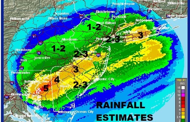
Some areas overnight added to the already impressive rainfalls from Saturday night and Sunday to make them even more impressive. This is probably the heaviest 2 day rain event in many months and goes a long way in alleviating dry conditions that have persisted since the start of winter. This is especially impressive during the month of February which is generally a cold dry month.
This morning we find ourselves still fighting the cold front from the weekend which is taking its sweet time drifting southeastward. As a result it is a cloudy morning with temperatures mostly in the 40s. To the south across Southern New Jersey we have rain continuing and it may take awhile before that rain sinks to the southeast. Everywhere else we have clouds with a northwest breeze that is picking up at times. Temperatures this morning are mainly in the 40s and we will probably see them settle in the upper 30s and lower 40s by the end of the day as colder dry air continues to push southward.
US SATELLITE

REGIONAL RADAR

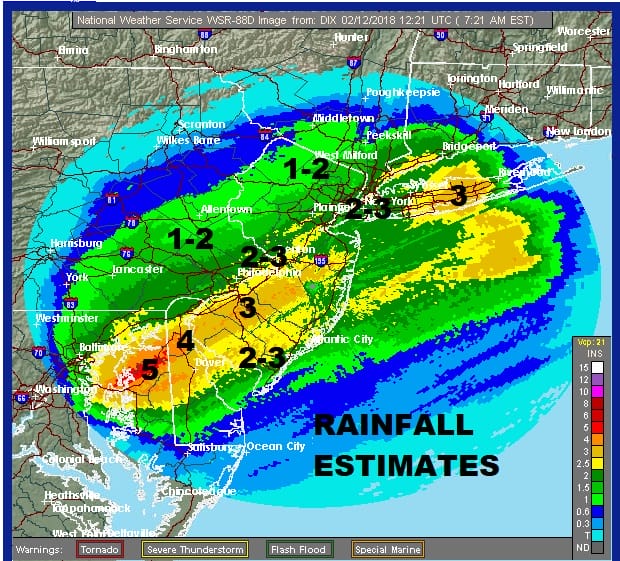
The regional and local radars continue to show the rain to the south moving northeast along the frontal boundary that is offshore. Eventually we will see the boundary shift far enough to allow for some clearing but until then Southern New Jersey will continue to see some steady rain into midday while areas to the north toward NYC & Long Island could still see another shower or two this morning.
LOCAL RADAR NEW YORK CITY

LOCAL RADAR PHILADELPHIA


We should see skies clear out tonight as high pressure begins to build in. Temperatures will drop to the mid teens to mid 20s by morning. Tuesday is Mardi Gras (Fat Tuesday) which will be nice and sunny with highs in the chilly 30s to near 40.
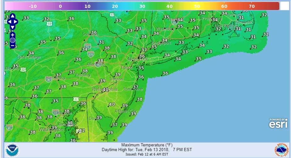
Then we move on to Wednesday which is Valentine’s Day & Ash Wednesday (there is a joke in there somewhere) which will also be nice for the most part with sunshine and some arriving clouds. It will be milder Wednesday with highs back into the 40s to near 50.
Thursday brings the arrival of the next warm front/cold front combination which is pretty much in line with what we have been seeing for the last few weeks. Showers Thursday morning followed by a break and more showers Thursday night into Friday are likely before the front passes through. This could be another 1 inch rain producer. This will be followed by a dry weekend. Long range there is absolutely no sign of any pattern change whatsoever.
 GET JOE A CIGAR IF YOU LIKE

FiOS1 News Weather Forecast For Long Island
FiOS1 News Weather Forecast For New Jersey
FiOS1 News Weather Forecast For Hudson Valley


