Flood Advisory South Jersey Rain Moving Eastward
Flood Advisory South Jersey Rain Moving Eastward
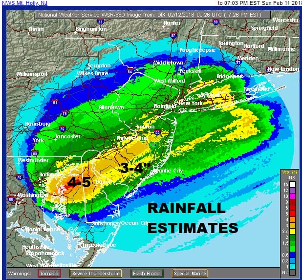
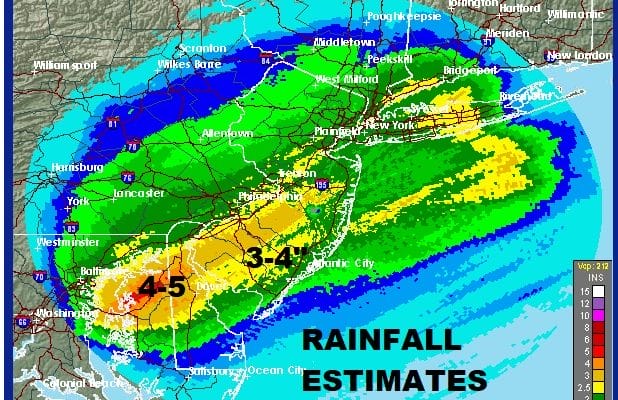
We are coming toward the end of today’s rains which have been substantial. Rainfall amounts from Northern New Jersey, Hudson Valley Connecticut & Long Island were in the inch to an inch and half range with a few locally higher amounts while rains in South Jersey were double that with some additional downpours showing up on the radars this evening. Dense fog is also developing around the area and this will be an issue until the weather front passes offshore and winds shift around and pick up from the northwest. That should happen later on tonight. Additional flooding issues are possible in the advisory area until the rains finally come to an end.
US SATELLITE

REGIONAL RADAR

LOCAL RADAR NEW YORK CITY

LOCAL RADAR PHILADELPHIA


Weather conditions should improve on Monday with clouds and some sunshine developing. It will be significantly colder in most areas with temperatures settling in the upper 30s and lower 40s. Tuesday with dry and cold with sunshine. Highs will be in the upper 30s to lower 40s. Then it turns milder on Wednesday with some sunshine and highs in the upper 40s and lower 50s. The next weather system will bring another warm front cold combination with clouds and shower developing early Thursday morning with more numerous showers Thursday night into Friday. It will be mild into Friday until a cold front passes followed by another quick shot of cold but dry air behind it.
 GET JOE A CIGAR IF YOU LIKE

FiOS1 News Weather Forecast For Long Island
FiOS1 News Weather Forecast For New Jersey
FiOS1 News Weather Forecast For Hudson Valley